A cadastral passport is the most important document for a land plot; without it, it is impossible to make any transactions. It is necessary that all data in this document be current and true.
If any actions were taken with the land plot that affected changes in its characteristics, then this must be properly recorded in the cadastral passport. And here it is worth talking about the procedure for making changes to this document.
If you want to find out how to solve your particular problem, please contact us through the online consultant form or call :
- Moscow: +7(499)350-6630.
- St. Petersburg: +7(812)309-3667.
When will changes be required?
Making changes is a procedure aimed at recording any changes in the characteristics of a land plot in cadastral documents.
Changes will be required in the following cases:
- the site has a new owner (due to sale, exchange, donation, inheritance);
- the area of the allotment has increased or decreased (for example, due to the reconstruction of the building);
- new residential or non-residential objects have appeared on the site;
- the area of the plot recorded in the title documents and in the cadastral passport itself are different;
- the address at which the site is located has changed (for example, when a street or settlement is renamed);
- the purpose of the land has changed;
- the cadastral value has changed;
- a forest, pond, or other natural object appeared or disappeared on the site.
As the practice of cadastral engineers in Russia shows, the most common situations in which changes to the passport are required are a change in the owner of the land and the characteristics of the site (for example, due to the construction of buildings).
It must be remembered that when dividing, merging or annexing neighboring plots, it is necessary not only to make changes to the cadastral passport, but to re-carry out the land surveying procedure, as a result of which the owner will be issued a new document.
The above reasons are a consequence of manipulations with the land. But it is also possible to detect errors that were made by third parties (cadastral registration workers or cadastral engineers). These errors come in two types:
- errors that arose as a result of the inattention of cadastral service employees and led to inconsistency of information (for example, typos, grammatical errors, arithmetic inaccuracies) - correction of such errors will not cause problems and occurs easily and quickly;
- errors that were made at the very beginning of the land surveying procedure and registration of cadastral documents by engineers, which resulted in distortion of the characteristics of the land plot in cadastral registration documents - these errors are quite difficult to correct, since in most cases it will be necessary to re-carry out the land surveying procedure and registration of all documents.
How to make changes to the state cadastre
Regarding the correction of errors, this is a special procedure provided for by law. Correction of errors is carried out either at the initiative of the cadastral authority, or at the request of any person, or by court decision. In any case, the authorized body makes a decision about the identified error and eliminates the error within five days, of which interested parties are notified.
We recommend reading: Is it possible to demarcate a plot of land without the consent of neighbors?
Information about a property may change over time for various reasons. It is advisable to reflect such changes in the cadastre. Otherwise, the contradictions that arise may become an obstacle to transactions and other manipulations with real estate, or greatly complicate their completion, as well as negatively affect the implementation of other rights of the owner.
What documents need to be prepared?
To carry out the procedure for making changes to the cadastral passport, the owner of the plot or his legal representative will need to collect a package of certain documents. It includes:
If you want to find out how to solve your particular problem, please contact us through the online consultant form or call :
- Moscow: +7(499)350-6630.
- St. Petersburg: +7(812)309-3667.
- a copy of a Russian citizen’s passport or international passport;
- a copy of the power of attorney (if the procedure takes place with the participation of a representative);
- documents that can confirm ownership of a land plot (sale and purchase agreement, donation, exchange, certificate of inheritance, etc.);
- a completed application for amendments to the cadastral passport;
- documents that need to be amended (cadastral passport, boundary plan, government resolution on transferring land to another category).
Making changes to the state real estate cadastre
Then, first, the owner will have to go through the entire cycle of measures to enter data about the previously registered plot into the cadastre. Confirmation may include acts of local government authorities granting the site for lifelong ownership or ownership, lease or perpetual use, etc. If the information provided is sufficient, then it will be entered into Rosreestr, and the applicant will be issued a passport with a plan. Even before personally contacting the cadastral registration authorities, the owner can independently verify on the public services portal whether Rosreestr has information about this plot or whether it is missing. This will help you immediately outline a plan for further action. The probability that there is no information about your plot in Rosreestr is 70%, since until 1999 a simplified procedure for maintaining documentation registering property rights to real estate was used.
How to correct inaccuracies in the cadastral passport?
When the characteristics of the site change
At the beginning of the procedure, the owner of the site must collect a package of documents that were described above.
If the owner submits the documents personally, then you can get by with ordinary copies of the documents, but if the operation takes place with the participation of a trusted person, then the copies must be notarized. As for the power of attorney, you must submit a copy of it to the package of documents, and show the original to an employee of the authorized government agency.
The application form can be obtained from the cadastral registration office, and here you can ask employees to help fill out the document. It is recommended to leave your contact phone number in the application so that if any problems arise, cadastral registration workers can quickly contact the applicant.
When accepting documents, employees of the cadastral registration chamber must issue a receipt indicating the date and time of acceptance of the documents, a list of all papers, as well as the date by which changes will be made.
The period for making changes to cadastral registration documents cannot be more than 18 days. If documents are submitted through the MFC, the period can reach 21 days.
On the appointed day, you should appear at the authority that carried out the procedure for making changes to the cadastral passport, present your passport and the issued receipt to receive the corrected documents, after which they should be transferred to Rosreestr. This completes the procedure.
If mistakes were made
If errors were made in the document during the land surveying process, the cadastral work will have to be done again. The algorithm of actions is as follows:
- Calling a cadastral engineer, concluding an agreement on land surveying.
- Making an advance payment by the customer;
- Carrying out preparatory work related to obtaining information from the Unified State Register - this procedure may take up to 10 days;
- Carrying out cadastral work by surveyors and preparing a boundary plan will take an average of a week;
- Coordination of the boundaries of the site with the owners of neighboring plots - up to 1 month.
- Correcting errors in cadastral registration and, directly, in the cadastral passport of a land plot - this stage occurs according to the algorithm described in the previous section.
Upon signing
housing cooperative agreements
you need to be extremely careful and check every point.
Are you planning to buy land with a house? Find out what documents you need to prepare for this transaction by reading our material.
Is the sale of land subject to tax? We talked about this here.
How to correctly submit an application for amendments to the cadastral passport
- Calling a cadastral engineer, concluding an agreement on land surveying.
- Making an advance payment by the customer;
- Carrying out preparatory work related to obtaining information from the Unified State Register - this procedure may take up to 10 days;
- Carrying out cadastral work by surveyors and preparing a boundary plan will take an average of a week;
- Coordination of the boundaries of the site with the owners of neighboring plots - up to 1 month.
- Correcting errors in cadastral registration and, directly, in the cadastral passport of a land plot - this stage occurs according to the algorithm described in the previous section.
- the site has a new owner (due to sale, exchange, donation, inheritance);
- the area of the allotment has increased or decreased (for example, due to the reconstruction of the building);
- new residential or non-residential objects have appeared on the site;
- the area of the plot recorded in the title documents and in the cadastral passport itself are different;
- the address at which the site is located has changed (for example, when a street or settlement is renamed);
- the purpose of the land has changed;
- the cadastral value has changed;
- a forest, pond, or other natural object appeared or disappeared on the site.
We recommend reading: Apartment rental agreement free of charge
When is it possible to refuse to make changes?
The owner of a land plot must understand that in some cases, changes to the cadastral passport may be refused. The reasons are due to incorrect documentation:
- the package of documents has not been collected completely, some important documents are missing;
- when submitting an application by the principal, copies of documents are drawn up incorrectly, the power of attorney has expired or it is drawn up with errors;
- incorrect completion of the application for amendments to the cadastral passport;
- making adjustments violates the current legislation of the Russian Federation.
To avoid refusal and additional hassle with documents, we advise you to submit your application in person.
This method of handling has several advantages:
- significant savings in money (if you submit an application through a representative, you will have to notarize copies of documents, as well as draw up a power of attorney; if you send documents by mail, you will also have to attach notarized copies and pay for postage);
- the opportunity to consult with government agency employees; any errors that may arise can be corrected immediately on the spot.
But if you are still denied, before filing a claim in court, we advise you to double-check the prepared documents and resubmit your request. If you are denied a second time, then you should go to court by filing a lawsuit demanding adjustments to the current cadastral passport.
There is nothing complicated in submitting an application to make adjustments to the cadastral passport - you just need to correctly prepare all the necessary documents.
Dear readers, the information in this article may be out of date. If you want to know how to solve your specific problem,
call the phones
:
- Moscow: +7(499)350-6630.
- St. Petersburg: +7(812)309-3667.
Or on the website. It's fast and free!
In recent months, one could see how many cadastral engineers almost unanimously argued that if the land plot is not surveyed before January 1, 2020, then the owner of the property right will lose the right to use his own land plot. Rosreestr had to urgently reassure citizens and give some explanations why this excitement arose.
Everything remains the same, but you need to be vigilant
First of all, Rosreestr explained that land surveying from January 1, 2020 will be carried out on a voluntary basis, as before, and no one will take away a land plot, even if you did not have time to go through this procedure before December 31, 2020. The second sign of excitement was most likely caused by the fact that cadastral engineers decided to interpret the law on land plots and the new law on cadastral real estate in their own way. The third sign is banal greed; cadastral engineers still wanted to make money from the legal illiteracy of the population.
Land surveying from January 1, 2020
Further, Rosreestr says that the new Federal Law-18 does not indicate anywhere about the timing of land surveying, which means that everything remains as before, but still, there is a certain recommendation on what needs to be done with the land plot after this period. An official representative of Rosreestr even pointed out the fact that Rosreestr does not speak anywhere on the website or in public statements about mandatory land surveying.
If your extract contains no information about actual land surveying, then you can easily go through this procedure after January 1, 2020, and the state will not apply sanctions to land owners.
What to do after land surveying and what the survey document looks like
Therefore, before the appointed time, all landowners need to carry out this procedure, although previously the law was not obligatory to do this. However, the Russian authorities are thinking about expanding the tax base through land properties and reducing the number of unregistered plots of land.
We recommend reading: How sick leave is paid to Chernobyl victims
After the survey has been carried out, as well as on the basis of the cadastral plan and extract, the cadastral engineer who was involved in this procedure on a specific land plot issues the applicant a special document - a survey plan, which is in paper form and certified by the personal signature of the cadastral engineer and the seal of the geodetic company. If necessary, an electronic version of the plan on virtual media is also issued.
Where did the rumors about urgent land survey come from?
Meanwhile, there remain a number of factors under which land surveying will still need to be carried out without fail from 2020, regardless of the actual status of the land:
- You have a dispute with your neighbors or the state is making claims on a plot of land.
- During the sale without land survey, one of the parties made a claim to the land plot.
Figuratively speaking, land surveying is necessary if there is some kind of dispute with one of the parties. In addition, you can sell your plot of land next year without surveying, but the lack of surveying can play a cruel joke on the new owner due to the fact that someone will make a claim
.
Therefore, Rosreestr gives only RECOMMENDATIONS for carrying out land surveying on a voluntary basis
. Thus, you will fix the coordinate points of the object of law for all occasions.
Land surveying in 2020
Is it possible to change the boundaries of a land plot after land surveying?
An error of this kind is corrected by sending an application to the cadastral registration authority, which is the FBU Land Cadastral Chamber. The main reason for the overlap of plot boundaries is, of course, cadastral error. An error of this kind is understood as the incorrect establishment of the boundaries of an allotment when carrying out land surveying work. According to experts, the cadastral error is caused by incorrect binding of boundaries, namely, the incorrect choice of a point that is the starting point for further measurements. Sometimes land surveying work is carried out along a fence delimiting areas that was installed incorrectly many years ago. Such situations may arise when the documents do not reflect information about the coordinates of the boundaries of the site.
We recommend reading: Average Living Minimum in 2020 in Moscow
It should be noted that in practice, a neighbor’s voluntary decision to change the boundaries of his property is extremely rare, because everyone is confident in the correctness of such boundaries. The main way to solve this problem is, of course, litigation. Send an application asking for the boundaries of the plot to be established in the court of your area.
Who does land surveying
The land surveying procedure is within the competence of cadastral managers. You can find the “Cadastral Register Engineer” section on the Rosreestr website, where you can select a suitable specialist from the list. In the register you can study the specialist’s data, as well as read reviews about him.
Stages of land surveying
The surveying procedure itself includes the following:
- Establishment and precise determination of coordinate points of the land plot.
- Attaching boundary markers to the site.
- Accurate determination of the area of land.
- Formation of a refined boundary plan, as well as completion of a topographic drawing, including based on aerial photography data.
- Entering data into the Roskadastre database.
This is the basic procedure for carrying out boundary work.
Stages of land surveying in 2020
How can an owner go through the stages of land surveying correctly?
The survey period may take up to 2 months; this is the maximum period determined by the cadastre law in the Russian Federation. In any case, during the land surveying process various changes in configuration and changes may occur. Coordinate points, by rotation angles
. Ultimately, you will officially secure your data in the Rosreestr database, and no one will be able to encroach on your land plot.
The land surveying stages themselves take place according to a specially approved scheme:
- We prepare the required package of documents in 2 copies for the geodetic service.
- An act is being developed to determine the coordinate points of the land plot, the signatures of the land owner, neighbors, government representatives, as well as the specialist who is conducting the work are signed.
- We receive one of the copies from the official master plan form.
- We present a document confirming the absence of arrest (in some cases this is not required, you need to check with a specialist).
- Carrying out geodetic survey of the area.
- Installation of boundary signs (special symbols in the form of flags or other identification marks).
- Drawing up a boundary plan that is submitted to Rosreestr.
- Receiving a new extract from the Unified State Register of Real Estate, indicating the new coordinate points of the land allotment.
Thus, you legally secure the right to the boundaries of a plot of land, and in the future you can dispose of your property at your discretion.
Remember that land surveying is voluntary, but if you don’t want problems in the future, we recommend that you do not put the matter off, but order land surveying from a specialist who will carry out the work in accordance with the requirements of Russian cadastral legislation.
https://www.youtube.com/watch?v=OkINZBOIZWc
Any land plot must be numbered and registered in the cadastral register. Information about the real estate is entered by the regulatory authority into Rosreestr. Based on these data, a cadastral plan of the land plot is drawn up, confirming the legality of its formation.
What documents will be needed
Before contacting any of the listed institutions, you will have to collect a package of documents required for such cases. Their list includes:
- a certificate confirming ownership (decree on the provision of a land plot, will, purchase and sale agreement, court decision, etc.);
- the applicant’s passport or document confirming his identity;
- passport of the authorized person + power of attorney certified by a notary (if the alternation is executed without the participation of the owner himself).
Despite the simplicity of the land surveying procedure, there are a number of difficulties. Almost all of them can be solved without problems if you get acquainted with them in a timely manner.
But changing the boundaries of a site after a previously carried out survey is quite difficult. Therefore, it is important to study in advance all the intricacies of the process and the conditions under which the landowner has every chance of achieving successful interleaving. In this matter, it is better to resort to the services of a lawyer experienced in land matters, who knows all the nuances of the process.
Basic Concepts
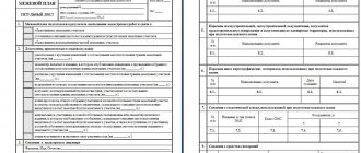
A cadastral plan is a document consisting of text and cartographic information. It displays the actual area, shape of the plot of land and the location of its boundaries. By order of the Ministry of Economic Development of Russia dated June 20, 2016
. No. 378 approved the form of the Cadastral Territory Plan.
The plan is drawn up not only in relation to the land plot. Houses, garages, and country houses are also subject to topographic registration.
. These structures are directly connected to the ground, and therefore are not taken into account in the plan separately from the site.
The cadastral plan confirms the legality of all transactions made with a land plot (sale, exchange, donation, etc. ), as it acts as a direct confirmation of the entry of data on a specific plot into the State Real Estate Cadastre
. In addition, the document certifies ownership of the land, since it contains information on the basis on which the cadastral number was assigned to the plot.
On the basis of the cadastral plan, the rules for the use of plots between neighbors are regulated, because it establishes the exact lines of demarcation between the territories of the plots.
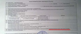
The structure of the document includes 5 sections. It looks like this:
- General information about the plot of land:
- information about the owner or tenants;
- location address;
- area and coordinates of boundaries;
- the purpose of cadastral registration;
- name of the body that entered the data into Rosreestr;
- allotment number;
- plan registration number.
- A drawing showing the boundaries of a real estate property.
- Text description of boundaries indicating adjacent land users on the territory.
- Data on parts of the land plot.
- Graphic information about the boundaries of the parts that make up the total area of the site.
Obtaining a cadastral plan
The legal owner can enter the land plot into the State Property Committee in one of the following ways:
- personally contact the cadastral chamber or MFC;
- seek the assistance of a qualified lawyer;
- fill out an application online on the official website of Rosreestr;
- use the Unified State Services Portal;
- send documents to the federal executive agency by mail.
It is most convenient to use the help of an intermediary company, but the price of the service varies from 500 to 2000 rubles.
An owner who wishes to obtain a cadastral plan must act in accordance with the following algorithm:
Collection of necessary documentation
Before visiting the cadastral chamber, the owner of the land plot needs to prepare the following package of papers:
- passport;
- a copy and original certificate of ownership of the plot;
- a plan drawn up based on the results of land surveying;
- act of coordination of boundaries with the owners of neighboring territories;
- a certificate confirming that the site belongs to a certain land use category;
- receipt for payment of state duty.
The control body affixes a stamp on all papers with the date of receipt of documents and registration number. An employee of the cadastral chamber signs the papers and issues a receipt to the copyright holder regarding the accepted documentation.
Application Form
Having collected the required documentation, the owner of the real estate submits an application to enter the provided information into Rosreestr. The application is written on a standard form and certified by the personal signature of the land owner
. The application can also be submitted electronically.
Issuance of the document by the registration authority
To obtain a cadastral plan, the applicant presents to the federal executive agency a passport and a receipt that was previously issued by the registrar.
An extract from the State Tax Committee is prepared within 5 days. The processing time for the document depends on the authority to which the application was submitted.
. If the copyright holder visited the cadastral chamber, then the production period is counted from the moment the application is filled out. When contacting the MFC, the production time is calculated from the moment the documents are transferred by the center to Rosreestr.
For individuals, the cost of state duty for a document is 200 rubles, and organizations will have to pay a fee of 600 rubles.
The grounds for refusal to issue a cadastral plan are:
- discrepancy between the content of the documents provided by the applicant and the legal requirements;
- appeal to government authorities by an inappropriate person.
Sometimes, when issuing a cadastral plan, the rights of the owner of the land plot are violated. In this case, the applicant can go to court
. Complaints against the actions of the competent authority are filed if:
- The document was provided later than the specified deadline.
- The federal executive agency refused to accept the documentation, although the papers were prepared in accordance with current laws.
- Rosreestr officially demanded that the copyright holder present additional documents.
The extract is valid for 5 years. After this period, the owner must draw up a new plan in order to carry out any legal actions with his land plot.
If the legal owner changes, new buildings appear on the territory, the boundaries of the site change, or landscaping works are carried out, re-registration is carried out before the expiration of 5 years from the date the cadastral chamber provided the previous extract from the State Property Committee.
How can I get a cadastral plan of a land plot?
When submitted to the Cadastral Chamber, all documents must be registered in a special journal. Using this record, you can clarify the time of receipt of documents, as well as prove the presence of documents at the time of delivery. The applicant receives a receipt from the KP employee, indicating the acceptance of each document.
Obtaining a cadastral plan of a land plot has been regulated since February 20, 2008, in accordance with the order of the Ministry of Justice of the Russian Federation. At the moment (since 2010), we can say that cadastral registration in Russia is in a transition period, but a new type cadastral passport can already be obtained from the Cadastral Chamber or the MFC. However, some stages of the procedure for obtaining a document may change in the future, so it is better to clarify the list of documents required for issuing a cadastral passport and plan in Rosreestr or in consultation with Star-Service specialists.
Checking the cadastral plan
Owners with access to the Internet can view the cadastral plan of their land plot on the Public Map. To find the desired area yourself, you should follow these steps:
- Go from the official site to the Public Cadastral Map.
- Enter the address or cadastral number of the plot of land in the column located on the left side of the screen.
- The area where the site is located will open on the map, which you can view by changing the scale.
- To obtain a cadastral plan, in the information section, select the column “Landing plan”.
The information provided to copyright holders is regularly updated, but the map does not yet include capital construction sites and existing security zones.
This check is carried out free of charge. Access to the map is open to all users of the global network. However, this method has not only advantages, but also disadvantages:
- In the absence of special technical extensions, the owner will not be able to find the desired scheme.
- The specified resource has small font, so the text data is difficult to read.
- The personal data of the copyright holder can later be found out and used for their own purposes by fraudsters.
Comments on the topic
The copyright holder can order a cadastral plan on the State Services portal. To receive an extract from the State Tax Committee you do not need to register on the website
.
Simply fill out the online form and pay the state fee
. The system verifies the data, and then the document is sent to the user by email or via Russian Post.
Virtual execution of a document is very convenient, because there is a lot of additional information on the State Services website, and you can pay the fee using an electronic wallet.
To register ownership of a plot of land, it is necessary to prepare a certain package of documents. The simplest option for collecting is to prepare them in a timely manner.
Among other documents, there is a mandatory cadastral plot plan, which is an integral part of
passports
. They are issued upon
registering an object
. The register stores basic information about the allotment, which is also recorded in the owner’s documents.
Since 2008, the form of papers has changed. Therefore, those owners who prepared them before this date must repeat the procedure for obtaining
. Also, a new passport and plan will be required if there are changes in the characteristics of the objects or the personal data of the owner.
It is necessary to know whether it is possible to change the cadastral plan of a land plot and in what situations this is provided for. The procedure is prescribed at the legislative level and has some features in 2020 that need to be remembered.
Who has the right to apply
Some persons who are related to the plot can initiate changes to the cadastral plan of a land plot.
These include:
- land owner;
- a person who has the right of ownership in accordance with the order of inheritance;
- a citizen who legally uses the allotment indefinitely;
- a person in whose favor encumbrances and restrictions on the allotment are established;
- authorized representatives of the above citizens who have notarized confirmation of these rights to conduct the procedure.
Download the encumbrance statement
Federal Law No. 210 has provided for information cooperation between organizations since 2011. In accordance with this, authorities can request information from each other without the request of the owner of the land plot.
For example, new information can be entered into the register when a neighboring plot changes. Also, employees can independently correct their technical and cadastral errors.
What to do if they demand
You need to apply to add new information to the cadastral plan in several cases.
You will definitely need to receive a modified document if a change has occurred:
- main technical parameters of the property (area, boundaries, etc.);
- allotment addresses;
- purpose of the land;
- cadastral value;
- ownership data;
- type of permitted use;
- some objects on the territory or in the neighborhood (forest, pond, natural objects).
If the owner is required to make changes to the cadastral plan, he must contact the Rosreestr office or the MFC. Not only a personal visit is available, but also sending an application by e-mail or regular mail.
Making changes to the cadastral registration of a land plot
- Boundary plan (for those situations when changes are made to the parts describing the location of boundaries and area of the site).
- The original and a copy (notarized) of a document that confirms the resolution of a land dispute about boundaries (if the boundary plan does not contain information about the approval of the boundary in the required manner).
- The applicant's passport (as well as a notarized power of attorney if the documents are submitted by a representative).
- A document certifying the applicant’s authority to speak on this issue (if the State Tax Code does not indicate information about the registered right).
- The original document that establishes or certifies the applicant’s right to the land plot. When a document is accepted by the caducerate authority, a copy will be made of the document with the stamp “original presented.”
- A document that confirms the type of purpose (for those cases when changes are made to this part of the land information).
- Location (that is, the address, and in its absence, a description of the location).
- Data on rights to the site and their owners to the extent contained in the Unified Register of Rights.
- Information about restrictions and/or encumbrances, as well as in whose favor they are established.
- If restrictions are not valid for the entire site, then data about the part for which they are valid.
- Data on the cadastral value of land, as well as the date on which such value was established.
- Data about natural objects (reservoirs, forests, etc.) that are located on the site.
- Category of land.
- Type of permitted use (purpose) of the site.
- Contact information for communicating with the owner or person who has the right of lifelong ownership of the land;
We recommend reading: Sample application to establish family relations
General formalities
New data can be entered when preparing the application. To do this, the owner submits a complete package of documents to the registration authorities
. The law provides for certain grounds for issuing an updated cadastral plan.
Content Features
Each land property must have a cadastral plan. It reflects basic information regarding the allotment. The same information is entered into the state register when the property is registered in the cadastral register.
. Therefore, data can be found in the cadastre by plot number.
Among the information that must be included in the plan are:
- general characteristics of the object (area, address, type of land);
- name of the body that carried out the registration of the territory;
- unique identification number;
- data on the existence of ownership rights to the plot;
- location of the site;
- information about neighboring objects bordering the owner’s land;
- purpose of state registration.
The document contains not only text information, but also a graphic block. A diagram of the land plot must be reflected
. It contains a description of the boundaries of the plot, as well as the objects adjacent to it.
The text block contains information about parts of the plot indicating their territorial contours. This data is not mandatory, as it may be completely absent.
The plan is prepared in two copies. This requirement is imposed by registration authorities.
Sample cadastral plan for a land plot:
Preparing an application
To make changes to the cadastral plan, you must submit a corresponding application. It is sent to the cadastral registration authorities.
The application must include:
- personal data of the applicant (full name, contacts, residential address);
- information about the allotment;
- data that needs to be changed in the cadastral plan.
applications for a land plot plan
In addition, certain documents are attached to it:
- A plan is being prepared that reflects the new boundaries of the allotment. It is first necessary to carry out land surveying to determine the size and area.
- If the boundary plan does not contain information about the approval of boundaries, then you must attach the original and a certified copy of the resolution of the land dispute.
- The applicant provides a passport for identification.
- If the application is carried out by an authorized person, his identification and a notarized power of attorney to carry out the procedure are required.
- A title document for a plot of land is required. The registration authority specialist will make a copy, compare it with the original and put a certification stamp.
- It is necessary to provide paper confirming the new type and purpose of the allotment. This is provided when entering information into this block.
Other documents by law cannot be requested by cadastral registration authorities. At the same time, no one except the judicial authority has the right to force the owner to reflect new information.
Documents can be submitted in person or by mail. Also common is access through electronic resources.
Main points
There are several main points regarding the procedure for making changes:
- New data must be entered only in accordance with government regulations.
- If unique or additional characteristics change, then two methods of treatment are distinguished. The first of them requires the owner to submit an application
. The second option is related to information interaction. - The application can only be submitted by the person who has the right of ownership of the plot. If a citizen resorts to the help of third parties, an official notarized power of attorney is issued.
- The application is considered by the registration authorities within 10 days. After this, a decision is made to enter new information, suspend consideration of the application, or refuse.
Grounds and principles of extradition
Cartographic information about the territory of the earth is transferred to paper and electronic media. They are mined using special precision instruments, which still allow some error.
The data is reflected in the cadastral plan of the plot, which is part of the passport. They are written in a concise manner. If discrepancies are identified, a cadastral or technical error must be identified.
In this case, it is imperative to contact the state cadastral registration authorities to reflect the new data in the documents.
There are other situations that require obtaining a new plan.
These include:
- loss of a cadastral passport;
- replacing the old document with an updated one;
- registration of a land plot;
- the presence of a court decision on the boundaries determined during the resolution of a dispute with neighbors;
- purchase of land from municipal authorities.
Instructions on how to apply and receive
A cadastral plan can be issued by the Cadastral Chamber after the boundaries of the plot have been established. Information on land surveying is reflected in the unified state real estate register. You can obtain a cadastral plan if you have a certain package of documents.
Among them are:
- land survey paper;
- a receipt confirming the fact of payment of the state fee;
- an application drawn up on a special form;
- title documents;
- applicant's passport.
Documents undergo mandatory registration in a journal. The entry reflects the date and time of receipt of papers, as well as a complete list of information provided
. The applicant is given a receipt of receipt.
Changes in the plan are reflected no later than one month after the application. Timing may vary if additional checks and examinations are required.
After completing the procedure, the person is given a passport extract with new data. It can be delivered to your home.
Conditions for changing the cadastral plan of a land plot
Some land plots change their status. For example, agricultural areas can be used for construction work. Also, there is often a change of ownership and boundaries of the allotment.
Any new data must be entered into the plan. The application is submitted to the Cadastral Chamber by the owner of the plot.
According to statistics, citizens apply for a new plan when the owner or characteristics of the plot change.
If there has been a division or unification of territories, then not only is it necessary to obtain a new document. A land surveying procedure is required to determine boundaries.
Sometimes the plan needs to be updated if mistakes are made. They are carried out by registration workers or cadastral engineers. All inaccuracies are divided into two types.
The first group includes errors resulting from the carelessness of cadastral specialists who enter information into the register. These include typos, grammatical and arithmetic inaccuracies. The fix happens pretty quickly.
If the inaccuracy is of a technical nature, then the change procedure is difficult. Such mistakes are made by engineers who incorrectly reflected the characteristics of the object.
. In this case, repeated surveying and issuance of papers will be required.
Procedure for registering a cadastral plan of a land plot
- The electronic procedure is cheaper for the applicant than a personal application to the government service.
- The registration period takes no more than 1 hour from the moment of application, whereas for personal application the period is 5 days.
- Convenience comes first, because from any available computer - at home or at work, you can send an application to the government services portal.
- An electronic document has equal legal force as a traditional paper document.
- By contacting the government service through the portal, you receive a lot of additional information that is difficult to obtain in any other way.
- Payment of the state fee can be made immediately when submitting the application online, using an electronic means of payment.
The main basis for drawing up a cadastral plan is the separation of this site from some other site. In this case, you have to draw up a new cadastral plan. If there is a change of owner, the cadastral plan requires its re-registration.