All articles
22680
2009-03-13
When selling real estate, a subject may encounter a technical or registry error. The presented material will tell you how to correct the error in the location of the boundaries of a land plot on the cadastral map, in which cases your participation is required and in which it is not.
Manipulations carried out with square meters and land require the preparation of an accompanying package of documents. The owner must present an extract from the Unified State Register of Real Estate . The certificate displays information about real estate, land, owner, and procedures carried out with real estate.
You can find a plot on a cadastral map, but the plot is not always displayed, which leads to a number of problems. The reason lies in a cadastral error.
Consequences
As a result of the presence of cadastral errors (CR), the property owner may encounter the following troubles :
- Will not be able to sell his property;
- Will not be able to rent it out;
- Will not be able to register an inheritance;
- The real estate tax or land tax will be calculated incorrectly.
Any legal actions related to this site or property will possible until the error is corrected .
Classification
According to their main classification, cadastral errors are divided into two types:
- Technical.
- Registered.
More details about them below.
Technical
This error means a discrepancy between the data entered into the electronic register database and the information contained in paper cadastral documents . As a rule, this is the result of an oversight and a shortcoming of the cadastral authority employees.
These include:
- Typos;
- Incorrectly indicated numbers, arithmetic errors in calculations;
- Incomplete information;
- The address of the object is incorrect;
- Inaccurate information entered into the register based on existing documentary errors in previous documents.
The procedure for correcting such errors, as a rule, does not cause problems. It can be fixed quite simply, and in a relatively short time , which cannot be said about registry errors.
Registered
Here the error lies directly in the paper documentation .
Such errors are typical for cadastral engineers, municipal employees, and land surveyors.
They are expressed as follows:
- Incorrectly established boundaries of plots;
- Incorrectly indicated area of the property;
- Incorrect land surveying;
- Erroneous data in the boundary plan.
This type of cadastral errors (often a registry error is called a cadastral error, without generalizing this term with a technical error) is more serious than a technical error, and it is much more difficult to correct. However, they are also fixable.
How is a defect detected?
The unreliability of cadastral data can be detected by:
- The owners of the property themselves;
- Concerned neighbors;
- Administrative bodies.
Most often, such errors are detected under the following circumstances :
- When making any cadastral changes;
- Obtaining a cadastral passport;
- Obtaining an extract from the Unified State Register of Real Estate;
- Registration of a plot (real estate) with Rosreestr;
- Removal of a property from cadastral registration;
- Upon receipt of tax notices where the tax is calculated based on the incorrect value of the object;
- In controversial situations with neighbors or other interested persons;
- Employees of the state cadastral authorities themselves discovered the error and sent a notification about it.
What to do to fix it
What to do if a cadastral error did occur in your case? Let us consider in detail several of the most common inconsistencies and the procedure for correcting them.
Boundary Overlay
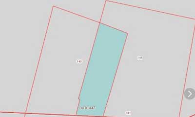
A fairly common cadastral error is the overlapping of two or more adjacent land plots on top of each other.
The reason for this may be inconsistency of legislation .
Before the introduction of Law No. 1453, which prescribed the land surveying procedure according to a unified system of state coordinates, an angular system was used.
Because of this, overlapping land boundaries arise.
Also, the reason for this may be the professional incompetence of the engineers who carried out the land surveying and drew up the cadastral plan.
If a violation is detected by the registry service employees, all work in this area must be stopped until all inconsistencies are completely corrected. If a cadastral error is discovered directly by the owner of the land plot, the cadastral authority should be notified about it and a request for correction should be made.
The correction procedure, depending on the current situation, can be resolved amicably, with the consent of all interested parties, or it can drag on for a long time.
In any case, you will have to do the following steps:
- Write an application to the local cadastral office with a request to correct the cadastral error.
- Notify your neighbors and coordinate with them all the nuances related to border issues.
If both neighbors and cadastral service employees agree with your claims , then there is a high chance that the issue will be resolved quickly and without unnecessary noise. But this happens quite rarely, so in such situations it often comes to litigation. What to do in such cases will be described below.
If, when overlaying sections, a technical error is detected, and not a registry error, then correcting it will not take much time.
Incorrect border location
In general, the boundary location error is similar to the previous one, only here the boundaries of the site do not overlap each other, but are displayed distortedly and have incorrect outlines and coordinates .
Such errors can also lead to a violation of the interests of the owner of the site or his neighbors. Any interested parties can submit a request for its correction.

After submitting an application to the cadastral authority, its employees are obliged to :
- Make a decision about the need for correction;
- Notify the owners and all interested parties of this decision;
- Appoint an engineer to re-survey;
- After carrying out land surveying and all cadastral work, enter updated data into the Unified State Register and notify the applicant about this.
Errors regarding previously registered land plots
Previously registered land plots are those whose information was entered before March 1, 2008 , when the change in land legislation was applied.
All cadastral errors in previously registered areas are corrected using the following algorithm:
- Pre-coordinate all actions with your neighbors. He must agree to change the boundaries;
- If all actions are agreed upon with the neighbors, an application to correct the error is written. Be sure to indicate what exactly the inaccuracy is and enter all the information about the site and its owner;
- The cadastral authority must send engineers to carry out repeated surveying, or a land management examination, and clarify the boundaries;
- In case of disagreement with neighbors or cadastral authorities, go to court.
Correction of an error by court decision
Disputes of this nature are considered only in arbitration, since the defendant is a legal entity. As soon as the court makes a decision, it is immediately sent to the Unified State Register for execution. EGRN employees comply with court orders.
When for any reason the court decision has not been received by the Unified State Register of Real Estate, the owner himself can submit a copy certified in court along with an application to correct the technical error. It should be clear from the court decision and the attached application what exactly must be corrected, as well as the deadline. If the deadline is not specified, then according to the standard, 5 working days are allotted for the execution of the court decision.
When, after receiving the application and a copy of the court decision, the necessary actions have not been taken by the USRN employees, then you can proceed in one of two ways:
- Send an application to the court indicating a request to issue a writ of execution based on the decision made. The received document can be transferred to the Bailiff Service to initiate enforcement proceedings. Further, the execution of the decision is supervised by bailiffs.
- You can submit an application to the court in which you demand to impose a fine for failure to comply with a court decision. At a separate meeting, the application will be considered and a fine of up to 100 thousand rubles will be imposed. When, after paying the fine, the decision is not implemented, then, on the basis of Art. 315 of the Criminal Code of the Russian Federation, you can submit a new statement about malicious evasion of the execution of a court decision to the investigator of the Federal Bailiff Service.
Also on the topic: What should I do if a neighbor put a fence on my property?
The costs of the owner of the site will result in payment for the services of a lawyer who will conduct the case, as well as state fees. Of course, nothing prevents the plaintiff from independently representing his interests in court, but as practice shows, the complexity of cadastral issues requires the involvement of a specialist to support his position in court.
How to fix it without going to court
So, let’s highlight the main aspects in solving problems related to cadastral errors, for which going to court is not required. As already written above, the main condition for correcting cadastral errors out of court is complete agreement with neighbors and cadastral services .

- An engineer should be invited to carry out cadastral work and draw up a new boundary plan.
- Notify local municipal authorities about the establishment of new boundaries of the land plot.
- Draw up an act agreeing on new boundaries with neighbors. It is compiled with the participation of a cadastral engineer and all interested parties.
Indicate in the act:
- Address of the land plot;
- Information about the owner of the plot and his neighbors;
- Data on neighbors' memory;
- Confirmation of neighbors' consent to the new boundaries of land plots;
- Date and signatures of all parties to the agreement.
Correction of an error at the request of the owner
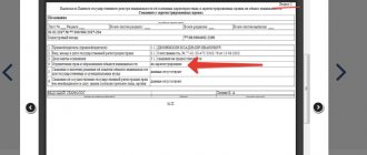
The applicant submits a special application to the territorial body of the Unified State Register or to the MFC, the uniform form of which was approved by Order of the Ministry of Economic Development No. 125 of April 13, 2009. It can be submitted in person or through the government services website. In this case, no state duty is charged. Additionally, you will need to attach all documents that confirm the fact of the error: boundary plan, site inspection report, etc.
A positive or negative decision based on the application must be made within no more than 5 days. The next day after the official decision is made, a copy of this document is sent by email or registered mail to the applicant. The owner of the plot must receive a copy of the decision and a cadastral passport if the decision is positive. The owner of the site is not notified of a negative decision.
If the applicant or owner is against the negative decision, they can go to court. In this case, both can appeal a negative decision, but only the owner of the site can appeal a positive decision (unless he filed the application).
Also on the topic: Nuances of a land lease agreement between individuals
Arbitrage practice
If agreement has not been reached with the neighbors on all fundamental points, or if the cadastral authority refuses to correct your mistakes for one reason or another, then you will have to solve the problem using judicial practice.
The defendants in this case may be neighbors, Rosreestr employees and other interested individuals.
The statement of claim must indicate :
- Information about the plaintiff;
- Information about the defendants;
- Information about the error due to which the litigation occurs;
- How and under what circumstances the non-conformity was identified;
- Actions taken to try to resolve the problem out of court;
- The desired result you are trying to achieve in court (for example, new boundaries, indicating preferred coordinates);
- The name of the judicial institution to which the claim is being filed.
List of required documents:

- All available initial documents related to cadastral work and registration in the Unified State Register of Real Estate;
- An extract from Rosreestr containing the alleged error;
- If the Unified State Register of Real Estate agrees with your claims, then there must be a special notification from them describing the discrepancy;
- Written objections from neighbors when trying to settle a dispute out of court.
If the court renders a verdict in your favor and obliges the relevant services to correct all inaccuracies, then the following events should follow:
- The applicant or the bailiffs present the judicial act to the defendant in the claim and to the employees of Rosreestr;
- The cadastral authorities dispatch an engineer to carry out land surveying work and eliminate errors;
- The updated data is entered into the electronic database of the Unified State Register of Real Estate within 5 days;
- All parties to the legal dispute must be notified of the changes made;
- Rosreestr employees notify the court of the execution of the court order and the elimination of all inaccuracies.
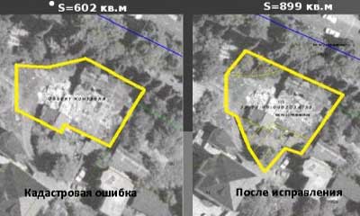
Cadastral error in the location of the site boundaries
A registration error in relation to a land plot is the transfer of inaccurate information to the Unified State Register of Real Estate from the contents of the boundary plan. Since the key role in the content of the boundary plan is to determine the characteristic points of the boundaries and location of the site, the correction of this cadastral error will be carried out according to special rules.
Detection of cadastral (registry) errors is within the competence of Rosreestr officials. In this case, the basis for identifying an error may be a statement from the copyright holder or other interested party.
The algorithm of actions of the state registrar who has discovered a cadastral error in the location of a plot consists of the following stages:
- making a decision to eliminate the identified error;
- no later than one working day, the specified decision is sent to interested parties whose rights may be violated by the identified error, as well as to the cadastral engineer to correct the error;
- after repeated cadastral work, the Rosreestr service enters corrected information into the Unified State Register of Real Estate, and notifies the copyright holder within five days.
Note! By virtue of Part 6 of Federal Law No. 218-FZ, at the request of any interested persons and authorities, the court has the right to make a decision to eliminate a cadastral error in the description of the location of a site.
Although the decision of the Rosreestr official to correct the error is of a notification nature, the copyright holder has six months to agree on all controversial issues. If within the specified period of time the violation has not been eliminated, and the corrected boundary plan has not been sent to the Rosreestr body, the following actions are carried out:
- an official of the Rosreestr service has the right to independently make appropriate changes to the location and area of the disputed site;
- the specified error correction will be carried out on the basis of information from title documents and the cartographic basis;
- when correcting a cadastral error in this way, the area of the land plot cannot be changed by more than 5% of the original value.
Also on the topic: How and at whose expense can a cadastral engineer’s mistake be corrected during land surveying?
In this case, the owner of the site and other interested parties retain the right to go to court to challenge the actions of the Rosreestr service.