Previously, this could be done with a note in the cadastral passport stating that “the boundaries have not been established.”
The document also lacked a graphic part, that is, there was no boundary plan.
The cadastral number is indicated in all documents along with the address .
With its help, a site can be quickly identified even in the absence of an address.
Land surveying has now become a mandatory procedure if you want to sell, donate or bequeath a plot. The cadastral number will remain the same after this.
When should it be done?
The dacha amnesty made it possible for many gardeners to register their plots of land under a simplified system. Everyone who participated in it registered their right without land surveying.
This was a timely step, since many land owners in SNT did not have the required amount to implement it.
Often, plots located far from the city in an abandoned state cost the same as required for full pre-sale preparation.
Now the situation has changed for the better for gardeners. But the question still stands: is it necessary to carry out land surveying of a site in SNT if there is a cadastral number?
There are several reasons why you need to hurry up with land surveying:
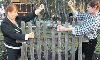
- Disputes with neighbors regarding boundaries . The situation is aggravated in the case when a cadastral engineer has already visited adjacent areas. In reality, the owner may not have the size of the plot that was stated upon receipt. Not everyone measured their plots, but were guided by the boundary, which could not accurately reflect the area of the allotment.
- Sale of land . It is unlikely that the buyer will want to receive a plot on which the coordinates of the boundaries are not clearly marked. Everyone knows how quickly neighbors' fences appear and the property can become much smaller than what you bought.
- Donation and bequest . It is preferable to first do the surveying and then complete the paperwork.
- The need to erect buildings or fences . By calling a surveyor who will accurately determine the boundaries, you will be calm that you will not violate the law or someone else’s border.
In other cases, no one forbids doing without this procedure, but, knowing the boundaries of your territory, you can be sure that no one will encroach on it.
From the beginning of 2020, complete disposal of your plot is possible only after the procedure for clarifying the boundaries of the land plot.
They must be indicated not only on the ground, but also on the public cadastral map. That is, information about each site must be included in the state cadastre database.
Why do land surveying if you have a cadastral passport for the plot?
Owners of cadastral passports obtained in a simplified mode (without land surveying) can use the land plot for their needs; this is not prohibited by law. But if your plans include the sale, donation or inheritance of a land plot, then you will have to establish the boundaries of your plot.
Land surveying.
Read about the timing and cost of land surveying here.
Land surveying is carried out by government agencies on a planned basis and by commercial organizations working on request.
If there is no need for urgent land surveying, wait for your turn to establish the boundaries of the site within the framework of the state program, free of charge (information about the planned survey can be found on the website of the local administration).
If you need an urgent sale of a plot, contact private geodetic companies. The cost of surveying services is calculated based on the size of the site, terrain features, and complexity of the landscape. On average, the price for establishing the boundaries of a land plot is from 10 thousand rubles.
Based on the current situation (the need to sell the site, pass it on by inheritance, fence it off from neighbors, financial capabilities of the owner), make a decision on urgent or planned land surveying.
Order of conduct
The procedure for carrying out land surveying on a garden plot is no different from how it takes place on land plots that are intended for individual housing construction or private household plots.
A competent approach guarantees reliable results. Let's take a closer look at how to carry out land surveying in SNT.
What organizations do they do?
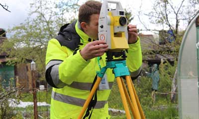
Land surveying is carried out by commercial organizations that employ cadastral engineers.
to demarcate the site yourself or with the help of neighbors ; accuracy is required here (up to 1 cm).
Cadastral engineers pass a special qualification exam and receive a license.
The accuracy of measurements is also achieved with the help of modern instruments.
It is advisable to make sure in advance that the specialists you call have accurate geodetic satellite equipment. Each cadastral engineer is responsible for the quality of his work.
Despite the fact that each cadastral engineer has a license for his activities, it would be useful to check his reputation.
What documents are needed?
In order to invite a cadastral engineer to your site, you need to take care of collecting documents in advance .
For full-fledged work, specialists will need:
- Passport . You will need identification of the owner in whose name the plot is registered. He can be replaced by a representative for whom a power of attorney certified by a notary has been issued.
- Certificate of ownership of a plot in SNT or an extract from the Unified State Register of Real Estate. If the land is not owned, but any document is needed on the allocation of the plot to a person for indefinite use.
- Any technical documentation for the site.
- Statement . Filled out on the letterhead of the organization or written randomly by hand.
The documents are examined by a specialist. If there are not enough of them to carry out land surveying, then the applicant collects the missing papers.
A cadastral engineer examines all cadastral and technical documentation for the land. Its composition may be different, depending on the status of the site.
Coordination of boundaries
Before surveying, the cadastral engineer notifies neighbors on the site about the need to be present .
But before the surveyor accurately determines the coordinates of the boundaries, you need to verbally agree with your neighbors on common boundaries.
If this does not happen, incidents with challenging the survey results are likely.
In addition to the informal part of the agreement, there is a mandatory procedure for signing the agreement by all interested parties.
They are the owners of all adjacent plots. If the neighbors are unknown, then you need to find out their place of residence from the SNT board. Notifications are sent to everyone about the need to participate in land surveying.
Neighbors are notified twice . If the neighbors were not present and did not explain their absence in any way, then the act is considered signed and the boundaries are established.
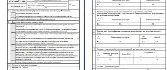
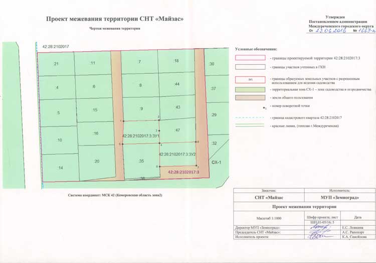
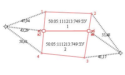
Draft land survey plan
The draft land survey plan consists of the main part and documents that confirm it. All papers are prepared and executed by a cadastral engineer; each sheet bears his signature.
The main part includes 2 components :
- text;
- graphic.
The text part contains several mandatory items :
- cadastral number;
- owner of the site;
- VRI (type of permitted use);
- information about the cadastral engineer (full name, signature, seal)
The draft boundary plan serves as a source of information for the customer himself and for the cadastral authorities. Land surveying is based on the materials of the survey plan.
A sample of the draft land survey plan for the SNT territory can be found below.
Approval of the draft plan
All coordination with the cadastral chamber is undertaken by a specialist who performs geodetic work on the site and prepares all documents.
Before contacting such a specialist, you need to agree on the boundaries with your neighbors.
If you do not know the address of the owners of neighboring plots, then you need to contact the SNT Board .
They must have information about the members of the partnership, including telephone numbers.
In addition to land surveying, the work of a cadastral engineer includes the coordination of boundaries with interested parties, that is, the owners of adjacent plots. They are sent notices by mail to which they must respond. Either name the reasons why they cannot appear, or sign an agreement.
If the neighbors did not come after the second notice and did not explain the reason for their absence, then the act is considered agreed upon.
If the SNT administration does not have the addresses of the neighbors you need, you need to contact the cadastral chamber .
Registration and receipt of results
After the surveyors have done all the work to determine the coordinates of the boundaries, the cadastral engineer, the customer and his neighbors must sign an agreement. This document is then filed in the survey file and becomes one of the materials on which the survey plan is based.
All land surveying documents are submitted by the cadastral engineer to Rosreestr . The owner can also receive these documents in paper or electronic form. In the cadastral chamber, the information is processed and entered into the database.
Features of plans in the cadastral sector
If we turn to the cadastral sphere, we can see that there are several options for schematic images, including a cadastral passport and a cadastral plan. Previously, until 2020, these were two independent documents, which were canceled with the introduction of Federal Law-218. Now all information is combined into an extract from the Unified State Register.
Now let's look at the main categories of the plan:
- Technical. A schematic part is being developed for a capital construction project, garages, apartment buildings and other structures. That is, a document is being developed for everything that is built on the land plot.
- Boundary plan. A document defining the boundaries of a land plot. It is being developed both for a plot of land and for an apartment building that has land and adjacent territory. A separate technical plan is being developed for the apartment building itself.
- Cadastral plan. A simplified or detailed diagram for one cadastral object. For example, a plot diagram or floor plan of an apartment building.
Each type of plan has legal significance, but only the cadastral plan is recognized as official confirmation. Previously, this document was a separate regulation, and sometimes was part of the cadastral passport. Starting from 2020, all old models of cadastral certificates have been cancelled. Now the cadastral plan is part of sections No. 3, 4 and 5 of the extract from the Unified State Register of Real Estate. All results of the boundary plan are transferred to the cadastral plan in the appropriate sections. That is, all information on the cadastral plan in the extract from the Unified State Register is official and has legal force.
The procedure for resolving disputes about the boundaries of garden plots
Resolving disputes with neighbors regarding acreage requires patience and knowledge. There are several subtleties that every gardener needs to know.
Especially if the boundaries of his allotment are the subject of disputes with other owners:
- If your neighbors have already demarcated their plot and the data is entered into the state cadastre, this does not mean that their boundaries are correct. It often happens that adjacent neighbors receive 6-7 acres as a result of land surveying, and the remaining plot is about 5 acres. The human factor plays a role here , when a cadastral engineer or cadastre employee can make a mistake. Plus - subtleties of legislation that neighbors could take into account. You need to submit all the documents you have to the court in order to defend the previous borders.
- The boundary, which has long been considered the boundary of plots in a gardening partnership, may not exactly follow the boundaries specified in the SNT documents. The same applies to fences, planted shrubs and outbuildings (sheds, bathhouses, etc.).
- First of all, you need to try to come to an agreement with your neighbors. Their consent must be documented . It is necessary to ensure that all notices are delivered on time and to the address. Copies of the shipment and all documents must be kept.
What is the difference between a cadastral passport and land surveying?
For this reason, citizens of the Russian Federation have many questions regarding land surveying.
Among other things, many are interested in: if there is a cadastral passport, is land surveying necessary?
Let's try to understand this issue in this article.
What do the laws say? The Land Code is responsible for regulating land issues in the Russian Federation.
Its first chapter contains information on how KZs are formed.
Chapter 114 tells about the section of KZ, and 115 - about their separation. Grave 116 describes in detail how different areas can be combined. And to get acquainted with information about the rules for handling new and changed CDs, you should open chapter 119. The last article of the code 11-10 discusses the requirements for drawing up storage diagrams.
In general, the abolition of mandatory land surveying occurred on 03/01/2008 after the release of the new law “On the State Real Estate Cadastre”.
Subsequently, changes and amendments were made to it.
Since the beginning of 2020, any transactions with memory without defining boundaries have been banned.
Is it worth doing the same thing twice and is land surveying necessary if there is a cadastral number?
The presence of a boundary and cadastral plan will not allow architects to locate construction projects within the framework of the master plan on your land plot.
- during expensive construction, so as not to touch “foreign” lands and clearly know the boundaries of “our own”.
First of all, you need to understand that an easement is a legal permission to use someone else’s property within strictly defined limits.
It is established either by mutual agreement of the parties or through the court. In this case, registration of rights to real estate is necessary.
There are two types of easements: private and public. A public easement requires land surveying, since it must be reflected in the cadastral plan, that is, establish the boundaries of the public easement on the land plot. If there is no land surveying, then more work will need to be done: both regular land surveying and taking into account the easement.
very important work in many ways
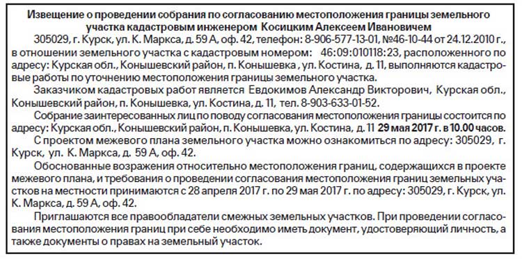
Text of the letter to a member of the SNT about correcting or agreeing on boundaries
The letter to the SNT member contains information regarding the time of the event and the area whose boundaries must be approved or corrected. There you also need to write the full name of the cadastral engineer and the customer of the work with addresses and telephone numbers.
At the end there is always information regarding disagreement with boundaries.
An example can be found below.