Accurate information about the boundaries of your land can be determined only after the surveying procedure .
Surveyors, using special instruments, will accurately determine the coordinates of the plot boundaries.
The procedure is preceded by the collection of documents, the conclusion of an agreement with a company or cadastral engineer and agreement with neighbors.
In this article we will look at how you can find out the boundaries of a land plot by address.
In what cases is it necessary
There are several reasons why it is necessary to know the exact boundaries of a property. Sometimes the owner or owner of the land is not satisfied with the information about the actual boundaries . That is, those that were installed “along the boundary”. They may not be precise, unlike legal boundaries.
With the help of precision instruments, a cadastral engineer can establish boundaries with an accuracy of up to a centimeter . The reason for a specialist’s visit may be the cancellation of the results of a previous survey or the merging of areas. Let's consider several cases.
Lack of understanding of real boundaries

One of the reasons for land surveying is the owner’s desire to know exactly where the boundaries of his property lie .
This mainly applies to plots located on the lands of SNT (horticultural non-profit partnerships).
Most of them were allocated for use back in Soviet times.
The measurements were inaccurate and, often, the owners themselves did not really know where the property line was.
Despite the fact that land surveying is an expensive procedure, many have tried to clarify the boundaries by calling a cadastral engineer.
Another example is installing a fence around the entire perimeter of the site . Since the fence is installed for several decades, sometimes for a lifetime, it is advisable not to doubt where it will go.
Making a deal
A change in land ownership is also a sufficient reason to determine the coordinates of the boundaries of your plot.
From a legal point of view, an undemarcated area can be :
- sell;
- give;
- bequeath
In general, dispose of your property in full (if you have taken ownership). The hype that is fueled in the media about the impossibility of making land transactions is artificial.
As a result of the execution of transactions, problems may arise that will prevent the transaction from being completed without land surveying .
For example, if the sale is formalized with the help of a notary who requests cadastral documents for the land. Or an error was discovered in the cadastral documents - the boundaries are crossed.
Areas where land surveying has been carried out are in greater demand than those where boundaries have not been established. The buyer wants to know exactly the area of the property he is buying.
Lack of agreement with neighbors
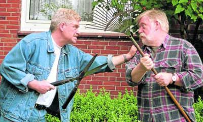
Disputes with neighbors over land boundaries are one of the most common reasons for starting land surveying. The procedure itself will not dot all the i’s. First of all, there must be a competent approach here. Therefore, it is important to find an experienced cadastral engineer.
Interaction with neighbors regarding boundaries can have 2 stages: negotiations and litigation . It is best to stop at the first one and resolve conflicts peacefully through mutual concessions. To coordinate and sign the relevant act, you will need to call your neighbors.
When relations with neighbors are cool, it is better to inform about the arrival of the cadastral engineer in writing, using a notice.
The notification is sent twice. If they do not come on the appointed day and do not inform about the reasons for their absence, then the boundaries are considered agreed upon.
In controversial issues, the problem of the boundary between plots is decided by the court.
Often, an independent examination is appointed .
The act of coordination with neighbors is part of the boundary plan.
Clarification of the amount of land tax
The tax base for land tax is the cadastral value of the plot. It depends on many factors, including area. Errors may occur when calculating taxes.
This happens especially often with areas that are registered in the cadastral register “without defining boundaries.” When they are clarified, the area may change upward.
In this case, it is necessary to conclude an agreement with one of the companies that are engaged in land surveying and invite a cadastral engineer. He will accurately calculate the area of the plot, and, taking into account all factors, the cadastral value. The updated data is submitted not only to the state cadastre, but also to the tax service.
What is a land title document?
The owner of a land plot, in addition to the cadastral passport and land survey plan, which reflect the main characteristics of the property, is required to prepare title and title documentation. These documents provide property guarantees for the owner and have different legal powers (they are not interchangeable).
This is important to know: Title document for residential premises owned
Title documents confirm the owner's privilege to use the property at his own discretion. Title documentation is the basis for establishing ownership of a property. Such documents are required to correct or confirm information about the owner of a plot as a result of a gift, sale or inheritance of land.
Title documents are also necessary to prove in court proceedings the legitimacy of claims to a specific property.
ATTENTION! Documentation issued by Rosreestr or BTI (for example, a certificate of registration of a transaction) does not apply to title. She cannot confirm the fact of transfer of ownership of the object from one person to another.
Documentation requirements
Legal documentation that gives the right to use or dispose of an allotment has a standard form, determined by legal acts on land. It reflects the following information:
- complete information about the owner (passport details, full name);
- type of right to real estate (gratuitous, lifelong, inheritable ownership, etc.);
- detailed description of the plot of land (size, location, features of the territory);
- allotment number in the cadastral register.
ATTENTION! The document receives legal force after registration with a state or municipal body. Corrections and deletions may result in refusal or suspension of the registration procedure.
List of title documents for a land plot
The list of title documentation was formed on the basis of Federal Law No. 122:
- agreements and acts on transactions with real estate (purchase and sale agreements, donations, etc.);
- a court decision that has entered into legal force;
- a will reflecting the inheritance of land by the person named in the document;
- resolution or order of local authorities on the ownership of a site by a citizen.
When leasing a plot of land, a corresponding agreement is drawn up, which also applies to title documentation. For the lease agreement to have legal force, it must be signed by the parties to the transaction and a representative of the locality administration.
Sample documents for downloading
Ways to define boundaries
There are several ways to define boundaries:
- On one's own . If the boundaries have not changed and the neighbors from adjacent areas are happy with everything, then it is possible to leave the boundaries that were before. This most often applies to SNT sections.
- Coordination with neighbors . It is one of the elements of land surveying. But if you agree with your neighbors on the boundaries and jointly sign the deed, then no additional documents will be required. This will save a lot of time.
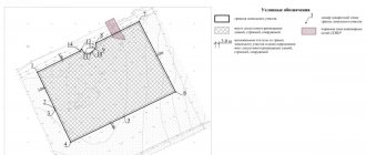
- Land surveying . A cadastral engineer or land surveyor will mark the boundaries of your site with pegs.
- Online . Using Rosreestr data, it is possible to obtain a site plan.
Everyone chooses the most acceptable method for themselves.
How to view data by address online
There are three known ways to view data on the boundaries of a land plot:
- On the official website of Rosreestr. In the “Electronic services” section there is a “Online reference information” item. After filling out the application and indicating your email address, the required document will be sent to you.
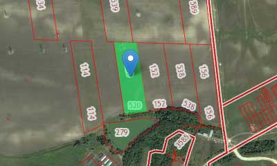
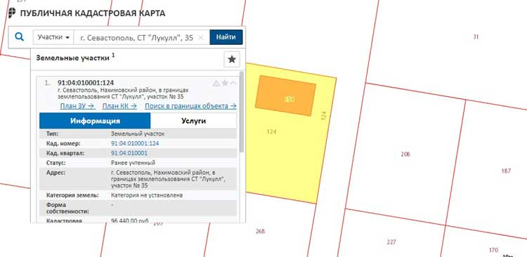
- On the Public Cadastral Map. In the search window, you need to enter the address of your land plot or information about which you want to receive. After the necessary data is displayed on the screen, click the “Information” section, where you can download a free plot plan with the specified data on the boundaries.
- Through intermediaries. This option is not so reliable; it is better to use trusted sources.
Typically, the time limit for sending these documents is indicated: from 5 minutes to 24 hours . But in reality they arrive by email quite quickly, within half an hour.
How and why to register ownership of the local area
The land plot on which the apartment building is located, as well as the adjacent territory, belongs to the owners of apartments (and other premises) in this building on the right of common shared ownership. This is stated in Art. 36 of the Housing Code of Russia. However, there are many houses, plots and local areas in the country that were not formed at the time and did not become the property of the residents.
Who owns the areas under and around houses?
Previously, the Land Code provided for a declarative procedure for registering property rights. Then this norm disappeared from the law, so now the ownership of land belongs to the owners of the premises by default (from the moment the land plot is formed, that is, it is registered in the cadastral register) and separate registration is not required.
If the site was not formed before the adoption of the Housing Code (before March 1, 2005), residents have the right to apply to state authorities or local government with an application to register the land in the cadastral register and register ownership of it.
As for new houses, even during their construction, shareholders receive the right to the land directly below it. However, it is necessary to clarify whether the adjacent area with elements of landscaping and infrastructure has been formed. If not, then the apartment owners also have the right to draw up documents and become its owners.
Is it necessary to register the land as a property?
No, this is voluntary. The decision on whether to become the owners of the plot or to leave it in municipal ownership is made by the residents themselves at a general meeting.
What benefits does this provide?
Residents of the house who have registered ownership of the plot under the house and the adjacent territory have the right to dispose of the land: make decisions about landscaping, landscaping, installation of a children's or sports ground, fences, barriers, etc. Part of the common property can also be rented out, and Use the proceeds, for example, to renovate a house.
When organizing local parking, residents can determine the number of parking spaces themselves, which is especially important for old areas; if a decision is made to demolish the building (as is happening, in particular, as part of the renovation program), then compensation to residents will be provided not only taking into account apartments , but also taking into account the land plot.”
This is important to know: Land tax benefits for pensioners and labor veterans
In addition, residents of houses with registered plots of land can protect themselves from the installation of unnecessary objects on their territory, for example, a paid parking lot or a kiosk. Without the knowledge of the owners, no construction can begin on their territory.
How to register a plot?
First of all, you need to check with the cadastral chamber or the MFC whether the plot is registered with the cadastral register. If it was not formed before March 1, 2020, any owner of premises in an apartment building has the right to apply to state authorities or local governments with an application for the formation of the land plot on which the apartment building is located. In Moscow, the application must be submitted to the city property department. Then you need to invite a cadastral engineer who will prepare a boundary plan.
It would also be a good idea to obtain a plan of the land plot allocated during the construction of the house from the local administration to make sure that the original boundaries of the adjacent land plot have not changed; if the boundaries change and the local authorities refuse to issue a plan, the owners need to go to court to restore the plan of the land plot within the original limits.
Then you need to contact the cadastral chamber or MFC to register the site for cadastral registration. The registration procedure takes about ten working days, after which the owners are issued a cadastral passport of the land plot. Then you should register the right of common shared ownership in Rosreestr.
What documents will be required?
The package of documents includes an appeal to the municipal authorities about the formation of a site and its cadastral registration, a technical passport of the house, a receipt for payment of state duty, minutes of the general meeting of residents, a boundary plan of the site, a technical registration document for an apartment building with information about the composition of the common property of the apartment building , as well as documents confirming that the owners have rights to the premises.
Will registration of the site entail additional costs and responsibilities?
Apartment owners will face financial costs for the maintenance of objects located in the local area, notes Maria Litinetskaya. The costs of organizing a parking lot or an area with exercise equipment, arranging flower beds and installing benches will fall entirely on the shoulders of the residents of the house. But the tax base will not grow, the expert added.
The owners are also responsible for ensuring the safety of life and health of people, fire and sanitary and epidemiological safety in the house and on the site.
What to do with repair work on the site?
Sometimes problems arise if apartment owners, who have registered the adjacent territory as their property and fenced it off, interfere with procedures such as laying utilities or power lines. To avoid conflicts, an easement may be imposed on the site.