The need for land surveying
Land surveying is one of the main conditions for fully exercising one’s rights in relation to a land plot. Without a specific establishment of the demarcation lines of the corresponding plot, it is impossible to carry out any actions with the land.
Generally, surveying is required in the following situations:
- For sale of land.
- To coordinate boundaries with neighbors.
- If there are any disputes.
- To increase the area of the site.
- When dividing the plot.
- To update documents.
As practice shows, buyers of land plots rarely decide to purchase undemarcated plots, as there is a risk of problems with re-registration and the risk of disputes with neighbors and government agencies.
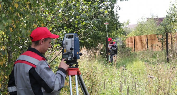
To carry out land surveying, it is necessary to conclude a civil agreement with specialists. They, in turn, take measurements, determine the boundaries and provide a ready-made plan to the customer, as well as to authorized government bodies.
Legal status of cadastral engineer
Private cadastral engineers act as specialists carrying out boundary work. Such specialists must have appropriate education, as well as an official certificate, which is issued by an authorized public organization - the professional association of cadastral engineers.
Only individuals can act as a certified specialist.
But they can carry out their professional activities in various forms:
- individual entrepreneur;
- private specialist;
- legal entity.
It is worth noting that, as a private specialist, a cadastral engineer certifies land survey plans only with his signature, as well as a special electronic signature with enhanced protection against hacking. Only individual entrepreneurs and legal entities have a seal.
To obtain a certificate, private specialists must pass a qualifying exam. The exam is taken by a specially authorized commission, which includes specialists with extensive work experience.
To do this, persons with appropriate education must contact the Self-Regulatory Organization of Cadastral Engineers in their area.
An internship is required. The internship takes place as an assistant to an existing engineer for two years. Changes made to legislation in recent years have made engineers responsible for the results of their work, which has significantly affected the quality of their services.
Stages of work
How long does land surveying take? If for a specialist the timing of land surveying is limited by the time of carrying out measuring work and drawing up site plans, then for the owner of the allotment this period is much longer.
From the owner’s perspective, the entire procedure consists of the following stages:
- Collecting the necessary documents takes from one to two months.
- Finding a specialist and drawing up an agreement with him will take no more than one day.
- As a general rule, a specialist, no later than two weeks from the date of drawing up the agreement, goes to the location of the site and carries out measuring work.
- Drawing up a land surveying plan until it is handed over to the customer also takes about two weeks.
- If necessary, you need to coordinate land surveying with your neighbors, which also takes some time.
Thus, for those who do land surveying, it is not always possible to predict how long it will take to survey a particular area. But the completion of the task by a specialist can be accelerated by including the appropriate condition in the agreement. Of course, you will need to pay extra for the speed of work.
How does land surveying work?
The process takes place in several stages. The first is the collection of documents that will be required to conclude an agreement with the organization conducting the survey. If the interests of the owner are represented by another person by proxy, a document certified by a notary is required.
If there are several owners, everyone will have to collect a package of documents. The work is carried out with the participation of all owners of shared property, so it is worth entrusting this to one of them, so that the rest do not need to go to the site.
After preparing the documents you must:
- choose a contractor;
- enter into a contract;
- carry out geodetic work, obtain a boundary plan;
- register the site with Rosreestr;
- register the right to property.
The last two stages can be combined. To do this, you need to take the documents to the MFC.
Coordination with neighbors
In turn, collecting documents and agreeing on the procedure with neighbors may drag on indefinitely. It all depends on the actions of the owner himself and the compliance of his neighbors. For this reason, it is worth preparing for the land surveying procedure in advance, and it is best to carry out all procedures at the time of purchasing the site.
Resolving certain issues with neighbors can avoid many lengthy disputes in the future, including litigation. If the neighbors do not make contact, then the owner must follow the procedure for notifying them established by law.
For this it is enough:
- post an ad;
- send written notices via mail.
In any case, the owner must retain confirmation of the notice in case of future disputes.
Actions of a cadastral engineer
In order for the cadastral engineer to begin boundary work, it is necessary to conclude an agreement with him.
We recommend that you read:
Why is land surveying or clarification of the boundaries of a land plot necessary and how to carry it out
After this, he performs the following actions:
- arrives at the site location and carries out measuring work;
- requests from the State Property Committee (state real estate cadastre) all information about the relevant plot;
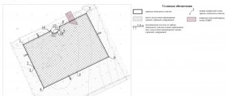
- draws up a text plan for land surveying;
- forms a graphic image of the boundaries of the site in relation to the geodetic map of the area;
- sends the documentation compiled for this site to the State Committee for Control;
- provides the customer with copies of the plan, certified by the seal and signature of the specialist.
The cadastral engineer bears administrative as well as property responsibility for the correctness of the work.
Carrying out project development work
An employee travels to the site to carry out field work:
- Topographic survey;
- Measuring the total area;
- Establishment of site boundaries;
- Coordination of boundary work with the owners of neighboring plots;
- Drawing a boundary.
The employee is obliged to complete this work and complete all necessary documents within 10-14 days. If questions arise, an employee can contact the customer during this time.
Cost of surveying
As already mentioned, land surveying is necessary for land management, but is by no means a free procedure. The services of private cadastral specialists are quite expensive.
In general, the cost of such a service is determined by several factors:
- the amount of work that needs to be performed by a specialist;
- region;
- number of required topographic nodes;
- the need to create a technical plan;
- the policy of the organization in which the specialist works.
For this reason, depending on the specific characteristics of the site, the availability of a complete list of documents for the site, and the price list of the specialist himself, the cost may vary from location to location. As practice shows, currently the services of cadastral specialists in different regions of the country vary from 3 to 15 thousand rubles.
Today, the cost of surveying one topographic node is one thousand rubles. As a rule, when surveying an allotment with previously undefined boundaries, at least four nodes are required. But depending on the availability of geodetic points established by government specialists, the number of required topographic nodes may be less.
Currently, the legislation has provisions according to which land owners can count on receiving a free land survey procedure from the state.
For example, such an opportunity has already been presented for summer residents, but in light of recent changes in legislation, the validity period of free land surveying has been extended until 2020.
This opportunity is provided in the following cases:
- when surveying a site with previously undefined boundaries;
- if the owner’s family has many children;
- when the family is registered for improvement of housing conditions in accordance with the procedure established by law.
The absence or presence of land surveying does not affect the owner’s ability to sell or buy a plot. However, the lack of clearly marked boundaries of the plot scares off many buyers. So, when selling, it is best to carry out the entire procedure immediately
How to register land
It is possible to submit documents through the MFC in order to immediately register the plot and register your ownership. You shouldn’t put it off until later, the form of the document may change, and you’ll have to do it all over again. The MFC has special application forms that must be filled out to provide the service.
The law stipulates that land surveying through the MFC must take place within 10 days, the period begins from the time when the Cadastral Chamber received the collected documents. If registration occurs through the MFC, then the period increases, which is due to the peculiarities of interdepartmental document flow. The employee receiving the documents issues a receipt and sets a date for the visit.
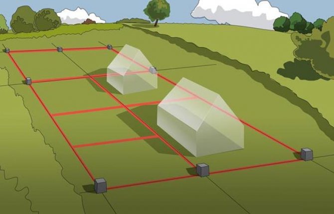
Demarcation of the boundaries of a plot of land is necessary to mark its boundaries, enter information into cadastral registration, and determine the market price. It is mandatory when connecting the site to utilities. A plot of land that has cadastral boundaries can be donated, sold or bequeathed.
Sample agreement for renting an apartment with the right to buy
All the details of renting an apartment, necessary documents, drawing up an agreement
Peculiarities of drawing up a contract for the sale and purchase of a land plot with a house
Details about calculating land tax
How to correctly draw up an agreement to terminate a lease agreement
How to write a complaint to the developer
Land survey deadline
When carrying out land surveying, deadlines must be observed. Some of them are mandatory for the owner, others for the engineer. But in any case, you need to fit within the time frame.
So:
- Neighbors and other interested parties must be notified of future land surveying at least a month before the date of the engineer’s arrival. Since it is impossible to accurately predict the date of the engineer’s arrival, it is best to do this a month before concluding an agreement with the engineer.
- The cadastral engineer, in turn, must carry out measuring work two weeks after the agreement is signed and the customer pays the agreed advance.
- The issuance of completed documents is also carried out within two weeks.
It must be borne in mind that depending on the location of the relevant site, the deadline for completing land surveying work may be extended, but not more than by one month. Thus, the total period for completing work to demarcate the site cannot be more than two months.
However, if errors are identified in the work performed, which is most often discovered when submitting documents to the State Committee for Taxation, the entire work will have to be done again. In this case, you need to contact the appropriate engineer to correct your mistake. Usually the engineer does this for free. All possible disputes are resolved through civil proceedings.
How to survey a plot of land for free
For ordinary citizens, free land surveying is possible only with complex cadastral work on the initiative of the state. Information about the upcoming and ongoing comprehensive land surveying is published on the municipality’s website.
Also on the topic: Types of liability for violations of land legislation
In this case, the owner can contact the cadastral organization indicated on the website (usually municipal) with an application to carry out land surveying of his plot free of charge. The application is written in free form, it indicates the address, cadastral number, as well as information about the owner (full name, passport details, etc.).
The reasons for applying for a free survey may be the following:
- Information about the land is not listed in the Unified State Register of Real Estate, but ownership was already registered before 1998;
- There is a documented cadastral error;
- Data about the site is available in RosReestr, but the object is not registered in the cadastral register.
In addition, free surveying is possible:
- As part of the dacha amnesty. But it would be more correct to say “free” rather than “mandatory”. Mandatory land surveying of dacha land plots was abolished back in 2007 and is not required for registration of ownership. But this will not last long - until December 31, 2020;
- Also, from June 1, 2020, amendments were made to the Land Code of the Russian Federation (Article 39.19 “Features of providing land plots in state or municipal ownership to certain categories of citizens free of charge”), according to which the procedure for free land surveying is applicable when allocating a newly formed land plot to citizens with three or more children and in need of housing (on special registration).
Duration of legal validity of the boundary plan
It is impossible to say exactly at what period the need to update the boundary plan occurs. Not a single legislative act contains any indication of this. Therefore, we can conclude that the boundary plan has no validity period, and it has legal force indefinitely.
But at the same time, when certain circumstances occur, owners and interested parties face the need to update the boundary plan.
These factors include:
- changing the boundaries of the land plot;
- clarification of demarcation lines;
- change of geodetic points according to the decision of the State Committee for Land Control;
- division, connection of plots, allocation of shares;
- detection of errors in land surveying;
- overlapping areas.
In all such cases, the land surveying procedure is carried out again at the request of the owners and other interested parties or by decision of authorized government bodies.
Another reason for updating the land survey is a change in measurement systems in the geodetic network. Any change in geodetic points or units of measurement entails the need for repeated surveying.
If legal requirements change, the land survey plan available to citizens may also lose its relevance.
We recommend that you read:
The procedure for land surveying in horticulture and the documents required for the procedure
For this reason, it is necessary to monitor all changes that are made to the legal acts (regulatory acts) of the country, as well as to local legislation.
Statute of limitations for challenging violation of rights during land surveying
In fact, despite the results of the survey, persons whose rights were violated during the survey can fully exercise their rights for an indefinitely long period of time. However, incorrect land surveying, as a result of which the boundaries of other owners or the owner who ordered the land survey were violated, is considered a violation of property rights, the protection of which is carried out in court.
Such disputes are resolved through claims proceedings. As a general rule, the statute of limitations is three years. This means that persons whose rights were violated during the land surveying procedure are entitled to challenge the land survey within the specified period.
But a characteristic feature of land ownership is that each specific unit of land is subject to tax. In this sense, the violation of the right is recognized as permanent. That is, if the property right to own land is violated, then it is not considered a one-time violation, since such a violation entails other consequences, for example, violations of tax laws.
That is, within the meaning of the law, such a claim is qualified as negatory, in which the violation of the right is recognized as permanent. This means that the statute of limitations rule does not apply to such violations.
Restriction of the rights of owners from 2020
Recent changes to legislation have made it impossible to buy and sell land without land surveying. That is, areas whose boundaries are not defined cannot be the object of civil circulation.
However, owners are given the opportunity to carry out land surveying or sell the plot without land surveying, which lasts until January 1, 2020. For this reason, it is worth carrying out land surveying of your plot if the boundaries of the allotment have not yet been marked.
Starting January 1, 2020, no plot that does not have a boundary plan will be able to be sold or donated. In addition, it is no longer possible to carry out construction work on such a site, and houses built on such sites cannot be connected to power supply lines.
In addition, it is already impossible to register newly created land plots without a demarcation plan. The responsibility for demarcating state-owned lands rests with local authorities. Thus, private individuals receiving land from the state have the right to demand land surveying from the local administration.
Carrying out land surveying serves the interests of the owners in the sense of determining the boundaries of their possessions in real form. That is, if an individual or organization bought land by carrying out land surveying, they will be able to pay taxes only on those units of land area that they actually own.
How it works?
To save time, survey results can indeed be carried out through the MFC, but this does not mean that all work is carried out remotely and does not require real measurements on the ground. Before preparing the necessary package of documents, you need to complete a number of preliminary procedures:
- Check whether this land ownership has been assigned a cadastral number. It can be found in the extract from Rosreestr, which is ordered through the State Services website or the same MFC. After checking the number, you need to find it on the Rosreestr map. If everything is in order, you can proceed to the next stage. If there is no cadastral number for the plot, you need to prepare an application in the prescribed form. Remember that after changes to the Federal Cadastre Law come into force (from January 1, 2020), assigning a number is only possible with an existing boundary plan.
- Select a contractor who will perform the required amount of work to establish the area and boundaries of land ownership. The process can be entrusted to either a large company specializing in geodetic work or a cadastral engineer licensed to provide this type of service.
- After preparing the boundary plan, you can submit it to the MFC in electronic form on disk. At the same time, the applicant writes an application for registration of the site with cadastral registration. The service is free, but if ownership of the plot has not yet been registered, you will have to pay a state fee. Completion of the process is the receipt of an extract from the Unified State Register of Real Estate, which will indicate the numerical characteristics of land ownership, describe the boundaries and provide other important information. It is on the basis of these data that the cadastral value of the land is determined and the land tax is calculated.