What is a situation plan for the location of an object?
The designation on a map of the area of a land plot with highlighted boundaries, buildings located on it, communications, and adjacent neighboring territory is called a “situational plan.” According to the rules, all construction projects on it are accompanied by information about the date of construction, number of storeys, street names, and house numbering are indicated.
Wikipedia states that a situational plan is a contour plan that does not contain information about the terrain of the territory. In other words, it uses horizontal surveying to create it, as opposed to a topographic geobase, which includes displaying elevations. In addition, the application of various objects is carried out using conventional signs that are understandable to users without an engineering education.
Ready turnkey situation plan
Order
When is it necessary?
To conduct a transaction of purchase/sale or lease of a property from the legal side, the situation plan is not a mandatory document.
Its presence is necessary to provide complete information about the boundaries of the site, the adjacent territory, nearby favorable and unfavorable areas, security zones, etc.
You will also need to order a situation plan in the following cases:
- obtaining permission to design and build a new facility;
- carrying out reconstruction of historical buildings, monuments;
- gasification, electrification of the site.
Situation plan by cadastral number online
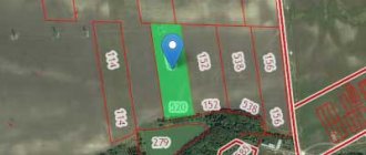
After cadastral numbers began to be assigned to all real estate objects in 2007, transactions with them are only possible if this identifier is available. The number is issued once and is assigned to the site, regardless of the change of owner.
All information is stored in the Rosreestr database and is freely available to users, which, in turn, makes it possible to obtain a situational plan of a land plot using the cadastral number.
The package of documents for issuing a site situation plan at the MFC branch includes:
- application on a standard form;
- real estate documents confirming ownership, or an extract from the Unified State Register of Real Estate;
- identification documents.
How to obtain gasification by cadastral number
Most often, they request a situational plan of a land plot for gasification. Laying gas pipes is not an easy task with its own characteristics. People’s lives and the safety of property: private and public may depend on this. Before starting work, it is necessary to request a joint venture. The urban plan will not be suitable; it may not take into account the latest changes in the territory.
You may be interested in: How to make your own estimate for apartment renovations
You cannot download it from the Internet. The network contains a sketch of the site, without fully accounting for all data and changes. Gasification requires studying risk factors:
- it is necessary to know the grounding points;
- see communication and electrical circuit diagrams;
- pipes are laid away from gas stations and other objects of increased fire danger;
- The terrain and the location of neighboring buildings are important;
- look at the distance to the object, calculate how many buildings will have to be connected: a bathhouse, a private house, a summer kitchen.
This information is stored in the situational plan. You can get it by filling out an application. It is addressed to the authorized bodies. The plot must be registered with the cadastral chamber and its number will be required.
Required documents
An application for the issuance of a joint venture is drawn up according to the standards. Local authorities will provide a form. In addition to this, you will be asked to present a number of documents.
- Passport.
- Right to property.
- Power of attorney, if a person acts on behalf of the customer.
The form specifies the reason why the SP is being requested. In most regions there is no state duty.
Plan for gasification
When agreeing with the operational services for connecting the site to the gas network, a mandatory package of documents is drawn up, which includes a situation plan with reference to local coordinates, drawn up on an A4 sheet. Information on the possibility of preparing a situational plan for gasification is provided by the local municipality.
To obtain a situational plan of a land plot by address, it is enough to indicate the exact coordinates of the location of the object.
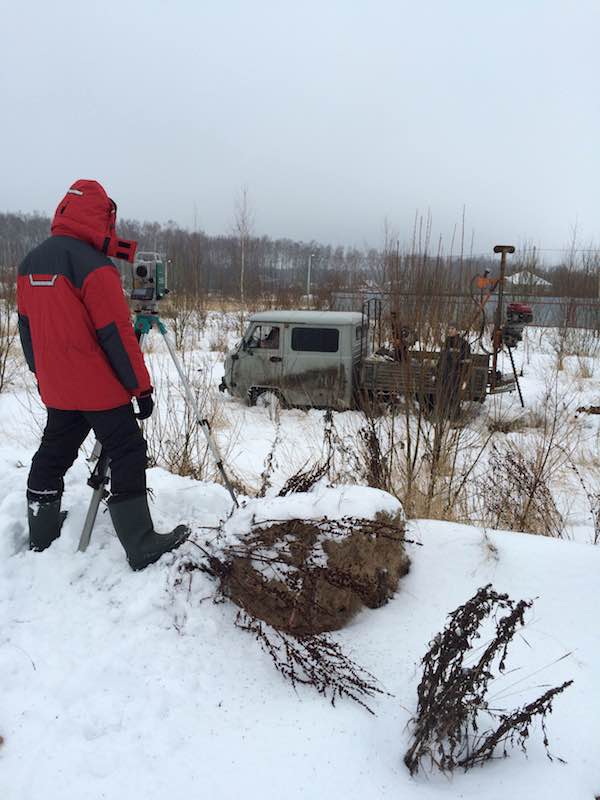
In the absence of such information, it is necessary to contact a specialized organization that will produce a situational plan of the land plot on a scale of 1:2000 after performing a topographic survey for gas.
It is also possible to prepare the document yourself. The basis is taken from high-resolution maps from open sources. Before this, it is necessary to notify the operational services in advance about independently drawing up a situational plan for the land plot for gasification.
What is a situational plan?
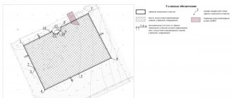
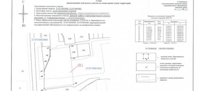
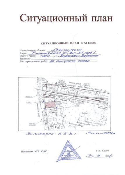
A situational plan of a land plot is a special diagram with a graphic representation of the plot and the surrounding territory, indicating the boundaries of the plot in the exact form of their location, created on the basis of topographic and geodetic work.
A detailed diagram is required for:
- assessment and analysis of the possibilities of supplying a gas pipeline to the facility;
- designing the supply of gas communications;
- carrying out repair work on the gasified area;
- as a demonstration material of the possibility of equipping a house with “blue” fuel when selling a building or plot.
The drawing contains graphic and analytical data about the object.
A situational plan of a land plot can be prepared for the purpose of personal information, for the installation of electrical networks, water supply and other communications. The objects depicted on the document give an accurate idea of the place and method of their implementation
The documentation consists of 3 parts. Each page is certified by a seal.
Includes:
- Project.
- Analytical data.
- Insolation information.
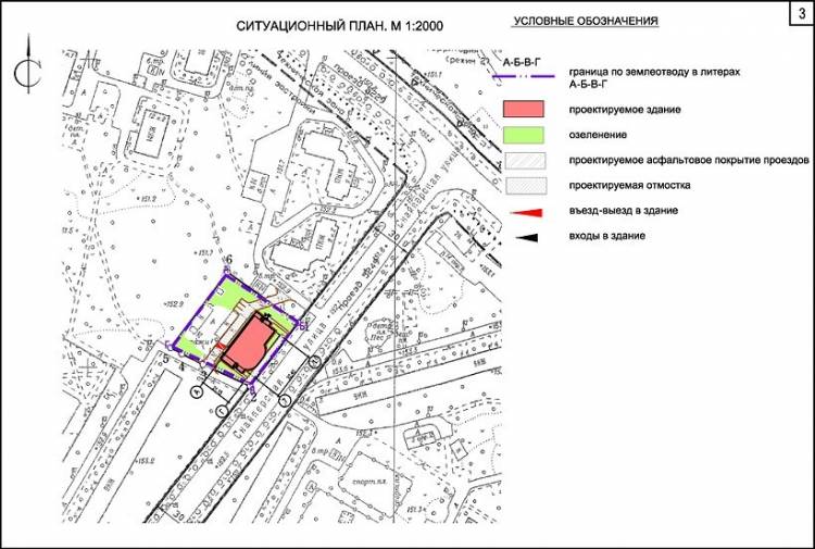
The project is most often executed on A4 paper in a scale of 1:2000. In this case, the cardinal directions, the schematic location of borders, road surfaces, engineering communications, and buildings are indicated. The location of gas pipes and their junctions is outlined as accurately as possible.
The analytical component is necessary to decipher the symbols, as well as the characteristics and affiliation of the object, in particular:
- exact location address;
- cadastral number is required (it must be assigned);
- all boundary data;
- location of communications on the site;
- information about existing buildings on the site itself and near it;
- roads, pavements, tunnels and so on;
- if there are security zones and unfavorable infrastructure facilities in the area;
- gas junction coordinates.
In addition, the document contains the timing of gas supply and a possible point of insertion into the gas pipeline.
The situational plan looks like a schematic map with a decoding, and the procedure for its preparation is fully regulated by the town planning code.
At first glance, it is difficult to deal with the huge amount of documentation.
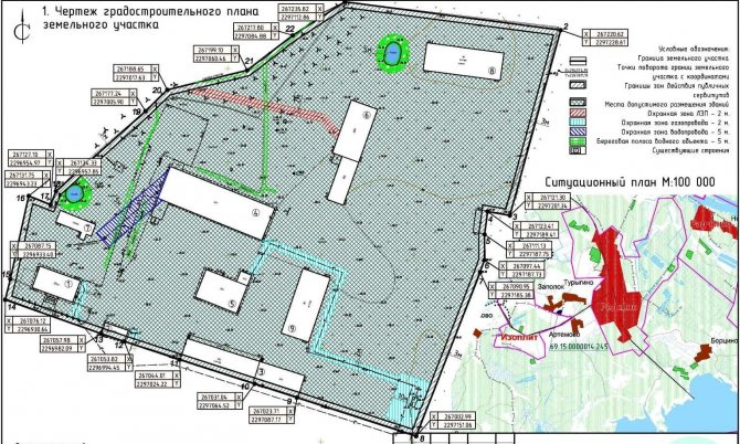
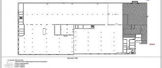
An urban planning plan displays planning data and analysis for development within a land plot with reference to the area. Compiled on the basis of geodetic and geological data
The urban planning drawing and cadastral plan are very similar to the situational one. Often people confuse them and try to provide one of these documents to the gas service. Meanwhile, the urban planning drawing can also be made in one of the following scales - 1:1000, 1:2000, 1:5000.
It indicates the information necessary for development, in particular, the possibility of building a house, its dimensions, number of floors, and so on. The GPZU has been in effect for a long time, but the situational plan is only 2 years from the date of approval.
The cadastral plan is based on land surveying; in its preparation, the procedure for topographic study of the area is not used.
Ground plan for electrical grid
An application to connect a site to the electrical network must be accompanied by a plan for the location of power receiving devices. The document contains two parts: text and graphic. The latter is a map-scheme M1:500 on an A4 sheet.
When drawing up a situational plan for electrical networks, you must indicate:
- clear boundaries of the site;
- main and secondary buildings;
- ground and hidden utility lines;
- power lines with external power supply;
- cable markings, protective equipment, grounding points.
You can obtain a plan for the location of energy receiving devices by cadastral number from the Rosreestr database.
Turnkey electrical plan
Order
Step by step guide:
- To do this, you need to register on the site and send the appropriate request.
- Next, the resulting situational diagram must be scaled to 1:500 and saved electronically or printed.
- Then find a sample situational plan for connecting electricity and, using a graphic editor, identify nodes and power lines on the site.
But it is worth noting that municipal energy service workers may not accept such an EPU plan for connecting power grids.
You can order the production of a document from organizations providing geodetic services. Specialists will take measurements, draw a diagram of the location of the control unit and compile a descriptive section.
Where to get a situational plan of a land plot
To order a situation plan, contact:
- in the MFC;
- to local government;
- online, through the “State Services” service;
- to a geodetic organization.
They do not have the right to refuse to issue a joint venture if they have a complete package of documents and a correctly drawn up application. In case of a negative decision without grounds, they turn to higher authorities with a complaint about the infringement of civil rights.
At the MFC
Multifunctional centers accept clients by appointment or on a first-come, first-served basis. A standard package of documents is required. The advantage of contacting here is that you can monitor the execution: just like when tracking a postal parcel. If the paper is prepared earlier, the client of the MFC center will see this.
Through government services
The situation plan can be obtained through State Services. To do this, you need to perform a number of actions.
- Register on the service, log in with your account.
- Fill out the form, send a scanned copy of your passport and title papers.
- Indicate the method of obtaining the result: at the address, via e-mail, in person.
- Wait for a notification that the paper is ready.
If the office is registered in the name of one person, and applications are submitted by another, you will need a power of attorney certified by a notary.
Terms of receiving the service
The document must be prepared within 10 calendar days from the date of submission of the application. Delaying the process is a violation of human civil rights.
Where can I download it for free?
Sometimes the legislation of local municipalities allows for the independent preparation of a situational plan according to the cadastral number. download the document from the Rosreestr database or compile it using maps from Yandex and Google services . Certain requirements are put forward for such a situational plan:
- presence of all necessary symbols;
- compliance with a given scale;
- supporting the data shown in the diagram with an explanatory note.
The difference between a situational plan and a general plan is that it contains relevant information at the time of preparation. In addition, the diagram is drawn up on a scale of 1:500, 1:2000, 1:5000. The master plan is prepared on a scale of 1:200, 1:500.
Where can I order a situation plan by address?
The architectural department is preparing a situational plan for a site in the Moscow region. In Moscow, issuance is carried out by Mosgorgeotrest.
You are required to print out a land plot plan by cadastral number free of charge within 3 days after applying.
It is worth considering that information in government databases may be outdated, and you will have to independently enter current information into the document.
In particular, this applies to real estate in the Moscow region. The situational plan of the site in Moscow may contain more up-to-date information due to frequent database updates.
How to compose it yourself
Since it is impossible to download a situation plan from the Internet, many people ask whether they can draw it up themselves. In some cases, this is acceptable: if it is used for general information, and not for work. A person who is familiar with the rules of drawing and has knowledge in this area can do it independently. Professional architect, designer.
You may be interested in: Everything about obtaining a town planning plan for a land plot
They download and print a map via the Internet and check the location of the land plot relative to other objects. All required information is applied, and the territory of neighboring areas is linked for accuracy.
A homemade situation plan is not suitable for submitting an application for restoration or construction, or for carrying out work on the site. And, moreover, it is not suitable for gasification. The paper may be useful only for personal purposes.
You can draw a map yourself. The difference between a situational plan and any other is that it can only be drawn up by government agencies. Professional designers are working on it, constantly making changes based on the latest data. Its value is exactly that. In other words, a document created independently will not be a situational plan. Even if it was made by the designer himself working on the site. It is better to apply for paper from the authorized bodies. The issuance period is short, it is free.