What is a land plot layout
A land plot location diagram (LPL) is a document that represents a plan of the boundaries of the created plot or redistributed territories. It is approved by authorized officials and is a graphic appendix to the order of the body responsible for the distribution of land resources. The diagram contains a description of the location of the site. It determines the specific location of the plot on the ground (coordinates), as well as the area and configuration of the boundaries of the allocated territory.
Layout of a land plot on the cadastral plan of the territory: what is it?
The layout of a land plot on the cadastral plan of the territory is a cadastral document prepared by a cadastral engineer during the process of land surveying. It is an integral part of land surveying, indicating information about the essential characteristics of the site. Regulated by the norms of the Order of the Ministry of Economic Development No. 762, adopted on November 27, 2014.
Order on the layout of a land plot on the cadastral plan
Why do you need a land plot layout diagram?
You will need a land plot layout diagram in the following cases:
- when creating a plot for the purpose of transferring a land plot to a citizen for rent without holding an auction, or for setting up auctions for land owned by the state or municipality;
- when registering territory for the purpose of subsequent seizure for municipal needs;
- when allocating an allotment that is owned by the municipality or the state, by dividing and transferring this land to citizens or organizations on the right of lease or free use;
- when creating a land plot by redistributing territories that are owned by citizens, as well as by the state or municipality. This procedure is popularly called - registration of an extension to an existing site;
- In addition, the diagram may be required when obtaining a building permit. In other cases, land is allocated by authorized state or local bodies in accordance with the land surveying and planning project.
Subsequently, a boundary plan is drawn up for the creation, division or redistribution of land. Two years are allotted for its preparation - it is during this period that the approved site layout scheme is valid.
Land plot layout and approval procedure
When a legal entity has managed to produce a diagram in one of three possible ways, approval awaits it. The local administration reviews a document that reflects all the main characteristics of the object.
→If she discovers that:
→The person submitting the scheme will face a refusal. When such a decision is justified by the document’s non-compliance with the standards, a competent specialist will be able to correct this and resubmit the site layout diagram for approval. |
Layout of a land plot in Moscow and the Moscow region for legal entities with a reliable contractor

The professionals of the First Cadastral Company are ready to produce a diagram within the agreed time frame and, in case of refusal of the municipal authority, to redo it in accordance with the stated requirements. Our cadastral engineers will thoroughly study the client’s situation, all documents, and order the necessary extracts.
After this, together with the customer, a decision will be made on the form of service provision:
- With departure;
- Remotely.
Drawing up a diagram when an engineer visits the site will allow you to get a more accurate picture. A specialist from our company will take measurements and, if necessary, make a topographic survey. This method will significantly reduce the likelihood of refusal when approving the layout. In addition, the results of such a detailed analysis of the site will help with further actions: land surveying and cadastral registration.
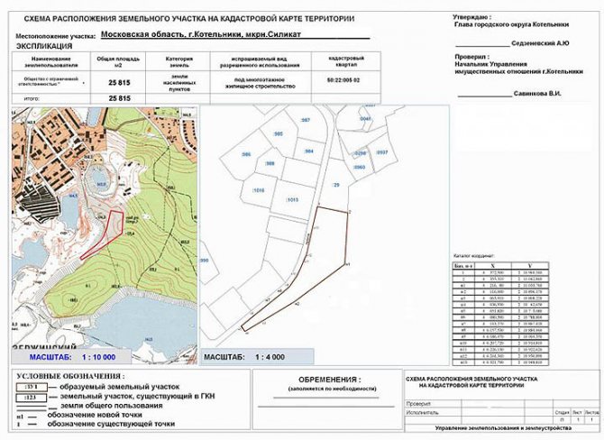
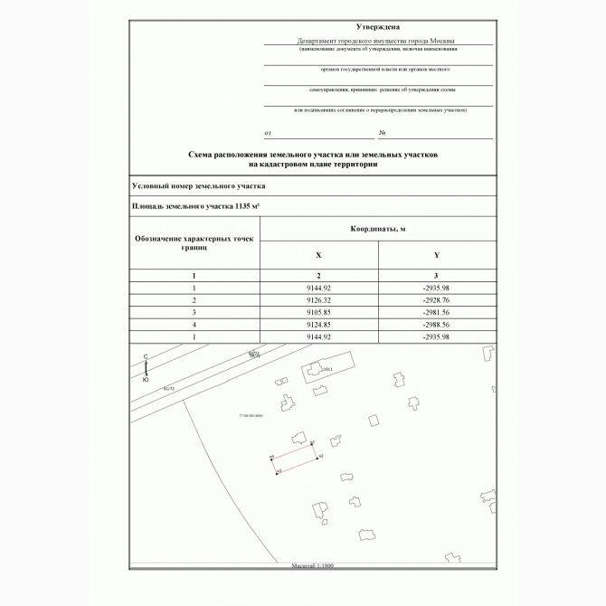
What does the land plot location diagram contain?
Requirements for the content of the layout of a land plot on the cadastral plan were approved by Order of the Ministry of Economic Development No. 762. Schemes have their own characteristics, which depend on the reason for their design. The document is usually drawn up:
- for land redistribution;
- to form a site.
There are also schemes created to divide territories that are owned by the state. In practice they are quite rare. When redistributing, the plan indicates both the site that is being acquired as a property or lease, and the site to which annexation is taking place. As a result, a single plot of land is formed, including an “addition”. If the allotment is created separately, then only it is indicated on the diagram.
The document should display:
- location of land plots;
- red lines;
- position of permanent structures on the ground;
- land planning projects;
- boundaries of territorial zones with special conditions of use;
- storage area;
- boundaries of the nearest plots that are registered in the cadastral register;
- conventional numbers of territories;
- boundaries of the land plot being registered;
- symbols that were used when drawing up the plan;
- a list of coordinates of characteristic points and their display on the diagram;
- information about the approval of the document by authorized bodies.
It is advisable to conduct a topographic survey of the site and surrounding area. There is no direct reference in the current legislation to its mandatory nature, but officials of many local administrations believe that topographic surveys should be carried out. This procedure entails additional costs, but also has positive features. For example, a topographic survey reveals all underground communications passing through the site. This will help to avoid in the future a number of problems associated with the use of land, as well as the construction of buildings and structures on it.
What is SRZU?
A land plot location diagram (LPL) is a documented plan of the boundaries of the created plot or redistributed territories. It is approved by local authorities and is a graphic appendix to documents on the distribution of land resources.
Thanks to this scheme, with the help of a graphic drawing and an explanatory text description, a detailed, clear description of the allocated area is given. It shows the area where the storage facility is located, its clear boundaries, shape, area.
How to prepare a layout diagram of a land plot
The document is approved by the administration on whose territory the requested land plot is located. And who draws up the diagram? The current rules give this right to a number of subjects. The scheme can be drawn up by a cadastral engineer or a body authorized to manage land resources. You can also prepare a diagram of the location of the land plot on the cadastral plan of the territory yourself. Let's look at all the options in more detail.
Method No. 1 - preparation by a cadastral engineer (I recommend)
The cadastral engineer draws up a diagram of the location of the plot on the cadastral plan without visiting the site, if he has sufficient information regarding the object. Otherwise, a specialist will need to visit and inspect the site. An engineer goes to the site and coordinates the boundaries of the territory if the location of the site cannot be determined office-wise. The results of its measurements can then be used in preparing the boundary plan if the SRZU is approved.
If the position of an object on the ground can be determined office-wise and a topographic survey of the area is not required, then a visit from a cadastral engineer is not necessary. The cost of a specialist’s services and the time it takes to complete a plan in this case will be several times less.
You can order a plot layout diagram without leaving your home. To do this, I recommend the ONLINE CADASTRE service, which sends the finished document within 2 days. Cost - 2400 rubles, official data and compiled by a cadastral engineer in accordance with Resolution No. 762 of the Russian Ministry of Economic Development.
Layout of a plot of land that I recently ordered through the ONLINE CADASTRE
Method No. 2 - registration by the administration (long)
The district administration is entrusted with the responsibility of drawing up a territory plan only in case of sale of land through an auction. In all other situations, the document can be submitted by the interested organization or citizen. This means that all costs are borne by the applicant.
A digital document is prepared for interdepartmental interaction. The body that allocates the land prepares an electronic diagram and sends it to Rosreestr. This is done so that before the registration of the right or within two years after the registration of the scheme, another plot does not form on the site of the described plot. The administration cannot require the applicant to submit an electronic circuit diagram. Otherwise it will be a violation of the law.
Method number 3 - self-preparation (free)
The legislation gives any citizen and legal entity the right to draw up a map of the location of a land plot independently. The main condition is compliance with the approved design standards, as well as the accuracy of determining the coordinates of boundaries and corners. If the applicant has skills in using a graphic editor and geoinformation programs, then he can independently draw up a plan for the location of the site. There is no need to put any signatures or seals on the document. Although some particularly “responsible” administration officials demand this too.
First, you need to order an electronic version of the cadastral territory plan (CTP) on the Rosreestr website. It is loaded into a graphic editor and the boundaries of the plot are marked using software. In order not to be refused, it is important to strictly adhere to the form of the document being processed. There should be no inaccuracies in symbols, etc. You should also understand that even perfect registration will not completely protect against refusal.
It would seem that it is profitable for municipal authorities to sell land, but they are reluctant to accept homemade documents. Most likely, they will offer to use the services of a cadastral engineer who will quickly and competently draw up a map of the territory. But do you want to pay for a document when everything can be done for free?
Problems with self-preparation of SRZU:
- When drawing up a plan yourself, you must use special software products, because only they will provide the required accuracy of area and coordinates. Under no circumstances do anything “by eye” using compasses, rulers and other similar devices.
- A big problem arises when there are no boundaries on the cadastral plan near the plot of land. In this case, determining the location of the land plot and “tying” it to landmarks will be extremely problematic.
However, you should not rejoice in advance if the plot layout plan has been accepted. The authorized body may refuse to approve it not only because of inaccuracies in registration. The law also contains a number of other reasons for refusal.
How to draw up a layout diagram of a land plot (on your own, without a cadastral engineer)
March 07, 2020 68143
The first and most important document in the process of obtaining land is the Land Plot Layout Plan (Land Plot Layout Plan) .
You will need this document in order to pre-reserve a land plot and begin the procedure for providing it to you as ownership or lease.
Along with the scheme, an application for preliminary approval of the land plot is submitted to the administration.
Many people believe that only a specially trained cadastral engineer can make a diagram.
This is a misconception that can serve as an obstacle to actively searching for and obtaining a plot of land.
In fact, you can draw up a layout diagram of a land plot yourself.
To draw up a land plot plan, you will need a little time, the Rosreestr portal and a trial (free) version of the AGRO 7 program (maybe the version that is current at the time of reading this article).
And your expenses for drawing up a site plan will be 300 rubles.
So, let's transgress.
Let's walk a few steps. At the end of the journey, you will have a ready-made scheme in your hands, thanks to which you will become much closer to getting your own plot of land :
Step one: Get a cadastral plan of the territory.
A cadastral plan of the territory will be needed to draw up a map of the land plot.
You can get it without leaving your home. Go to the Rosreestr website in the section obtaining information from the Unified State Register of Real Estate and submit a request to receive a cadastral plan of the territory.
To submit a request through the Rosreestr website, you will need the number of the cadastral quarter in whose territory you have chosen a free plot, and the amount of 300 Russian rubles.
You can learn in detail how to find vacant land plots from the first part of our guide to obtaining land from the state.
You will most likely receive a cadastral plan of the territory on the next business day after submitting and paying for the request. Rosreestr should send you a notification and you will be able to download the cadastral plan of the territory.
Step two: Download the trial version of Argo 7.
You must open files with a cadastral plan of the territory received from Rosreestr using the trial version of the Argo 7 program (download the version that was current at the time of reading this article).
To draw up a Land Plot Layout Scheme, the trial version will be enough for you, since it contains all the tools necessary for this.
You can download the program on the developer’s website: https://new.argogeo.ru/
Step three: Upload the cadastral plan of the territory into the Agro 7 program and draw up a diagram of the land plot.
Perform the following manipulations:
1) Open the program and click on the “Create a new drawing” button.
2) Load the cadastral plan of the territory into the Argo 7 program and click on the “Add to drawing” button.
3) Find on the cadastral plan of the territory the cadastral quarter on which the land plot we need is located.
The cadastral quarter is highlighted with a colored line so you can easily find it.
4) On the land plan, load the topographic base to display a satellite map with all the infrastructure.
To do this, directly from the program we select a raster background for our cadastral quarter, and it will automatically be displayed on our drawing.
5) Circle the contours of the site on the map using points.
After you mark the contours of the area with dots, the program will automatically calculate its area and display the coordinates of all points.
You need to indicate these coordinates in the application template for preliminary approval of the provision of a land plot, which you will submit to the administration.
6) Draw up the final layout of the land plot.
To do this, highlight the selected plot of land, copy the picture and paste it into the diagram template.
Fill out the table with the values of the coordinates of the points, indicate on the diagram the number of the cadastral quarter, cadastral numbers of adjacent plots, and the area of the plot.
Step four: Fill out the Application for preliminary approval of the provision of a land plot.
Using a ready-made template, draw up an application for preliminary approval of the provision of a land plot.
In order for the process of granting a land plot to be launched, attach the prepared diagram (plan) of the land plot to the completed application for preliminary approval of the provision of the land plot and submit all documents to the administration. After 30 days you will receive a response.
Conclusion.
As noted earlier, it is believed that the preparation of a land plot plan should be carried out by cadastral engineers.
In this Question, you should take into account the fact that it is not a fact that the administration will approve the land plot that you have chosen.
If you hire a cadastral engineer to draw up a diagram of a land plot, then, in the event of a legal refusal to provide a land plot, you will have to look for another plot of land and draw up a diagram again, I pay the cadastral engineer for the work. Do you need such expenses?
It is advisable to invite a cadastral engineer only if the site you have chosen has been approved by the administration and it is necessary to survey the site. Until this moment, it is more profitable to draw up the scheme yourself, without unnecessary expenses.
The step-by-step scheme for preparing a land plot layout outlined in this article is compiled on the basis of the video instruction “Drawing up a land plot layout diagram”, which describes in more detail the algorithm for drawing up a land plot layout diagram.
| We recommend using the video instructions and mastering the entire process of preparing a land plot layout diagram yourself! | Take advantage of our SPECIAL OFFER! |
|
|
| If you already have a scheme, you can purchase templates for all the necessary documents to receive land from the state. | If you don’t want to draw up a layout plan for the land plot yourself, we will draw it up for you! |
|
|


We wish you successful acquisition of land and a happy, healthy life on earth!!!
Reasons for refusal to approve the layout of the land plot
Often, the administration on whose territory the requested land plot is located does not accept the land plot schemes the first time. The document may need to be revised. There is no need to worry about this and argue with responsible employees. It should be clarified what exactly the officials are not happy with. You may just need to make minor adjustments to the legend.
They also refuse for far-fetched reasons. Of course, the administration may have its own plans regarding the requested territory. Then the applicant will be bullied for years until he himself renounces his claims to the land. There are few reasons to refuse approval of the plan, but enough to get on the nerves of interested parties.
Refusal is allowed if:
- the document does not comply with the approved requirements of Order No. 762 of the Ministry of Economic Development;
- the boundaries of the plot being formed cross the boundaries of another plot that is already registered in the cadastral register;
- the boundaries of the created plot intersect with the boundaries of another plot, the layout of which has been approved and its validity has not expired;
- the allotment being created does not comply with the requirements of current legislation;
- the boundaries of the site contradict the area planning project or land management documentation;
- The land plot is located in the area where the land surveying project has been approved. The reason for such a decision is usually the discrepancy between the site described in the attached diagram and the approved land surveying and planning project. In this case, obtaining ownership or lease of land in the specified location will be very problematic. The only solution is to include the site in the project.
What to do if the Administration refuses to approve a land plot plan
Coordination and approval of the layout of the land plot
The finished scheme is subject to mandatory approval by authorized bodies. In particular, the finished document, executed in electronic or paper form, must be agreed upon:
- executive authority of a separate subject of the state;
- local government body.
This rule, by agreement, applies in all cases, with the exception of some established at the legislative level.
Based on the results of reviewing the scheme, the authorized body makes a decision that can either approve it or imply a refusal to approve it.