Why is land surveying necessary?
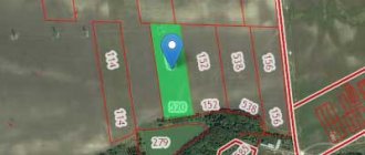
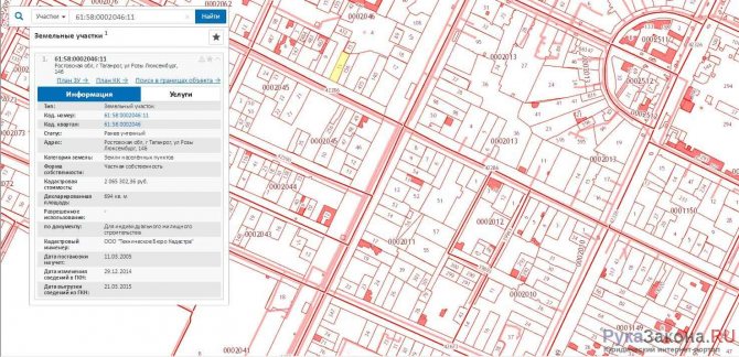
First of all, you and I need to understand what land surveying is and why is it needed? In simple terms, this is a geodetic method of determining the boundaries of a plot of land in a horizontal plane; it is also called land surveying or arpantage. The result of marking the boundaries will be a boundary plan. You can see the typical form of this plan in the picture below.
standard form of boundary plan
Important: To register a land plot in the state real estate cadastre, you will definitely need a boundary plan.
It is worth noting that this is not the only document that you will need when registering ownership of your land.
Documents for the application
Before submitting an application, it is important to prepare in advance all the necessary documents for land surveying, which are needed in order to check compliance with legislative acts.
| For individuals | For legal entities |
|
|
Application for land surveying: .
What does the law say about land surveying?
Land surveying in the Russian Federation is regulated by the Land Code of the Russian Federation and the relevant acts prescribed therein.
Here is a list of these federal laws:
- “On land management”;
- “On the state land cadastre”;
- “On the state real estate cadastre”;
- And in some cases others.
Our legislation treats issues of division and marking of land plots very strictly. Without land surveying, any manipulations with the land may subsequently be canceled by a court of the Russian Federation and considered illegal. It is very important for the owner to go through this procedure, otherwise using the site for personal purposes will be considered illegal.
For all subjects of the Russian Federation, the basic land surveying rules will be identical, but the procedure itself may vary. For example, in Moscow and the region this procedure is complicated and has its own nuances. In order to clarify exactly what actions need to be performed, we recommend that you contact the territorial office of Rosreestr for more accurate information.
The distribution of the boundaries and area of your site cannot be done independently. Such operations can be carried out by legal entities or individuals who have a valid license to perform cartographic, geodetic and engineering work, not excluding specialized government agencies. The cost of surveying services will vary and depend on the territorial location of the site.
What does the law say about land surveying?
The following have the right to free land surveying:
- owner;
- user of land with the right of lifelong inheritable possession or perpetual use;
- a tenant who has entered into an agreement for a long term.
When the landowner learns about the complex work being carried out, he can contact the cadastral organization (the work contractor) with an application to have his plot surveyed. The application is written in free form, it indicates the address, technical characteristics of the land, information about the owner (his full name, passport details, registration, telephone, email, etc.).
This is important to know: How to file a claim in the magistrate’s court: procedure and necessary documents
What documents will individuals and legal entities need to carry out land surveying?
The application package differs slightly between individuals and legal entities.
List for registration by an individual:
- passport of the owner of the plot and its copies, if the owner is not involved in the registration himself, then the passport of his representative and a general power of attorney issued for him, as well as their copies, will be required;
- documents confirming ownership of the plot: Contract of purchase and sale of land; Donation agreement; Certificate of inheritance; Resolution of the administration on the provision of a plot of land to the customer; Certificate of state registration of rights.
- documents from the BTI (Bureau of Technical Inventory): usually this is a certificate about the absence of buildings on the site or a cadastral passport of the building if there is one;
- cadastral extract from the register;
- cadastral plan;
- application for boundary work.
To order land surveying by a legal entity, you will additionally need documents from the organization itself.:
- Power of attorney confirming the powers of the legal entity;
- Certificate from the tax office confirming the registration of the legal entity;
- OGRN (Certificate of state registration of a legal entity);
- Extract from the Unified State Register of Legal Entities (Unified State Register of Legal Entities) or from the ERIP (Unified Register of Individual Entrepreneurs).
If among the documents for your plot you only have a purchase and sale agreement, then you should separately order additional documents from the following government agencies: Federal Service for State Registration, Cadastre and Cartography or BTI. We recommend that you prepare the necessary paperwork in advance and check the list with Rosreestr by calling toll-free. Also make photocopies of the entire list of documents, and when ordering certificates from the Cadastre and Cartography Service, if possible, order 2-3 copies - this is free for citizens of the Russian Federation and will significantly speed up the land surveying process.
what documents are needed for land surveying
List of documents for land surveying
The following documents are required for land surveying on the basis of the law:
- Identity card of the applicant - an individual or a representative in case of applying to the authorized bodies of the organization, attaching a power of attorney. Organizations are also required to have a package of documents: a constituent agreement on the formation of the company, a charter with prescribed types of activities, a decision or protocol on the appointment of a person authorized to act on behalf of the company - the head of the enterprise. Certificates of organization registration and tax registration.
- A document of title on the basis of which the owner has powers in relation to a land plot - a certificate of acceptance of inheritance, a contract of sale, exchange, donation, privatization, an act on the allocation of a plot of land to a citizen or legal entity.
- Confirmation of land ownership - a certificate from the Rosreestr, if the transfer of rights was formalized before 2020, or an extract from the Unified State Register of Real Estate when receiving documents on ownership after January 1, 2017.
- Application form for carrying out boundary work.
- Confirmation of the boundaries of the land plot: cadastral plan or extract from the Unified State Register of Real Estate with the characteristics of the land plot, a certificate from the BTI about the absence or construction of a structure on the plot with a description.
All documents should be obtained in advance, before contacting an organization that has permission for boundary work. This will significantly speed up the process of performing the service.
Quite a lot of people write to us with many of the same questions: how to choose an organization for land surveying? Is it necessary to do land surveying at all and why? Is it possible to buy land if there are no clear boundaries? - for your specific case, it is better to seek advice from an experienced specialist - ask your question.
Papers are provided in originals and copies; it is better to immediately order a certificate from the Cadastre and Cartography Service in 2 or 3 copies for submission to various authorities; duplicates are issued without charging a fee.
How does the land surveying procedure work?
As mentioned earlier, land surveying is carried out by a special organization or person licensed for this type of activity. The customer has the right to choose a specialist at his own discretion. You can contact the Rostekhinventarization bureau or ask for advice from friends who have already surveyed their site.
The work is carried out in accordance with the laws of Russia and includes:
- Collection and verification of all required data about the site, including studying the documentation provided by the customer;
- Preparation of a land surveying project;
- Notifying interested parties (owners of neighboring plots) in connection with the procedures being carried out;
- Scheduled visit of a specialist to measure and determine the boundaries of the site, taking into account the actual area of use;
- Determining the coordinates of a land plot by conducting geodetic surveys using special equipment;
- Accurate calculation of land area;
- Drawing up a site plan (indicating boundaries and coordinates) from previously obtained data;
- Making boundary work.
After completing all stages, the customer will receive two copies of the survey document. One will be transferred to the Cadastral Chamber, and the second will remain in the hands of the land owner.
The procedure for surveying a plot with and without a cadastral number
The process of establishing the boundaries of a land plot on the ground is represented by several stages:
- Collecting documents, obtaining consultation from authorized bodies if necessary.
- Registration of the land surveying project.
- Obtaining information about the owners of neighboring land plots, including by ordering extracts from the Unified State Register of Real Estate. Sending them notifications or providing them with a written message in person about the need to distribute joint boundaries in the area.
- Departure of a specialist to carry out cartographic and geodetic work - surveying an object on the ground, establishing its boundaries, determining the area.
- Determining the boundaries of a land plot, establishing the occupied territory on the ground by installing special boundary signs. It is prohibited to demolish them; administrative liability in the form of a fine is imposed for this.
- Drawing up a land survey document based on a drawn up deed establishing boundaries, signed by neighbors, and the results of a topographic survey.
There are some differences depending on whether the land is assigned a cadastral number. It is reported when submitting documents, including applications for land surveying.
If it is not assigned, then the procedure for drawing up a land survey file is preceded by the procedure for cadastral registration. To do this, you need to contact Rosreestr with an application and title documents for the land. The site will be registered within 20 days.
Documents for surveying a land plot with a cadastral number are processed faster, since no additional procedure is required. In this case, the period for drawing up a land survey with the consent of all neighbors will be approximately 1.5 months.
Is it possible to carry out land surveying without documents?
Many people face difficulties in collecting the necessary papers. Some people's documents may be lost or simply damaged. Of course, without a passport and title documents, a boundary application will simply not be accepted. And in case of their absence, you need to hurry up and restore all the missing papers in advance.
But with regards to certificates and extracts that need to be obtained from the State Registration, Cadastre and Cartography Services, and BTI, everything can be simplified. Here the same specialists who will be engaged in land surveying can help us. The only thing is that they won’t do this for you for free and you will have to pay them the appropriate amount according to the price list; you cannot name the exact price; it all depends on the contractor. Therefore, to save money, it is better to prepare everything and get it yourself.
Why is a land surveying act needed?
An important point in the land surveying process is to notify all interested parties about the establishment of new boundaries. After which everyone's consent is required. In most cases, this affects the interests of your neighbors, who own their plots on the basis of a certificate of ownership, perpetual use, lease or by inheritance. Coordination can be carried out separately with each owner or through a meeting. After delivery of the notice, each interested person must express his consent or other point of view and sign the act. In case of refusal, a reasoned explanation must be attached.
In practice, there are two options for the development of the situation:
- The neighbors are not against the declared borders and coordinates. If the act contains signatures of all owners of adjacent plots or their legal representatives, it is agreed upon. In the absence of a signature from one of the neighbors after a certain period after notification, the act will also be considered agreed upon, unless the neighbor has provided written disagreement;
- The neighbor does not agree with this act. In legal practice, such cases are very rare, but they create many problems. In this situation, the objection, drawn up in writing, is attached to the boundary file and is considered an integral part of it. Such a plot will most likely be successfully registered, but subsequently the neighbors may go to court with an application for a land dispute. Therefore, it is better to peacefully settle all disputes with neighbors and put all signatures on the act.;
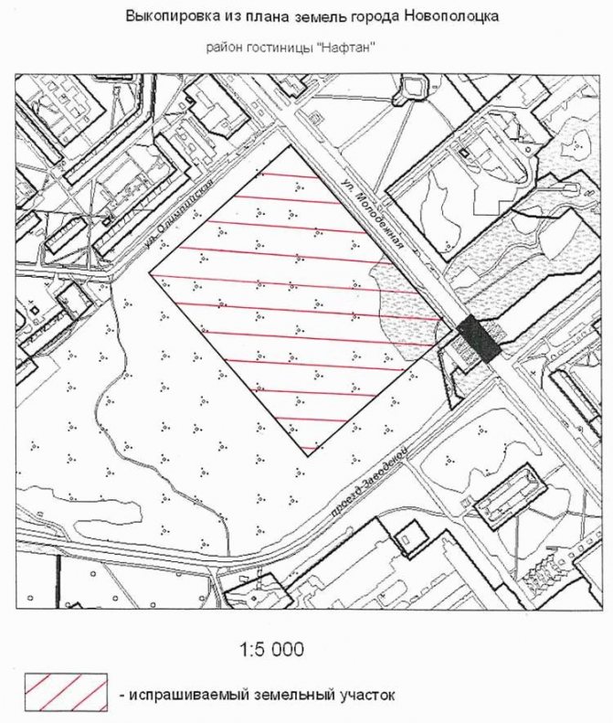
Copying
A copy is a part of the master plan of a settlement, which schematically shows the site and surrounding areas. It must contain:
- decoding of symbols;
- indication of scale;
- Full name and position of the executor;
- Date of preparation.
Expert opinion
Kurtov Mikhail Sergeevich
Practitioner lawyer with 15 years of experience. Specializes in civil and family law. Author of dozens of articles on legal topics.
To obtain a copy, the owner must contact the architectural department of the administration or the multifunctional center. The document production period is 3 working days.
This is important to know: Job quotas for people with disabilities