Why is this being done?
All Russian land and all structures erected on it must be registered, because in this way a citizen confirms the presence or absence of land ownership. In this regard, its taxes are formed. In order to collect taxes fairly and promptly, the government needs to know about a citizen's land ownership.
If a citizen owned property before the introduction of cadastre laws, the right to it remains, but any transactions or transactions with it are impossible until it is registered with the state cadastral register.
There are different types of cadastres, but in this article only one will be considered - land cadastres. This type of cadastre also includes all structures erected on land property. There are several reasons for entering possessions into the state real estate cadastre:
- separation of one area from another;
- the emergence of a new site;
- division of one property into several;
- construction of a building, premises;
- redevelopment, allocation of rooms indoors;
- division of the structure (if it passed to several owners through shared donation);
- any changes made to the land or structures on it;
- transfer of premises from non-residential to residential and vice versa.
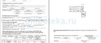
Cadastral passport
After the plot is entered into the state real estate cadastre, its owner will receive a special document called a cadastral passport. The definition of this term is as follows: an extract from the state real estate cadastre with information about the property. However, only certain categories of citizens can receive such a document.

If a person is the owner of land or a structure on it, leases it for a period exceeding five years, has the right to lifelong ownership through inheritance or perpetual use of the site/structure, he can submit documents and receive a passport. Representatives of the above categories of citizens can also receive this document from their legal representatives who have a notarized power of attorney.
There are cases that are considered individually:
- transfer of an unregistered land plot or structure on it by inheritance;
- the property acquired by the citizen belongs to the state/municipality.
What is a public cadastral map
The concept of a public cadastral map
After cadastral registration, all information enters the Unified State Register of Real Estate, which was previously called the Unified State Register of Real Estate. It must be said that such information is publicly available, any person who is interested in it can request and receive it. You can obtain an extract from the Unified State Register of Real Estate, or information can also be obtained from the official Public Card of Rosreestr.
A public cadastral map, or Rosreestr map, is an electronic database with information that contains information from the Unified State Register of Real Estate, namely:
- real estate cadastral number;
- address of the location of the property;
- main parameters of an apartment or house, total and living area, etc.;
- the main geodetic boundaries of the property must be indicated;
- when the real estate was registered in the cadastral register;
- what is the form of ownership of the property?
Such information can be found in the Public Cadastral Map, the information is in graphical and text form, and the geographic location on the map of our country is indicated.
Rosreestr is responsible for the completeness and accuracy of the electronic resource data, and the use of data from the public map should be based on the principles:
- openness and accessibility. The information of the Public Cadastral Map is freely available, it can be used by those who are interested in it, and there is no need to carry out any complex identification for this;
- reliability, this means that the information presented in the electronic database coincides with the data of the Unified State Register of Real Estate. If there were any changes to the parameters in the property, then the data must be changed in the map;
- relevance, this means that if there are any changes in the characteristics of the property, they must be entered into the Public Cadastral Map on a daily basis.
The main purpose of the public cadastral map is information awareness of citizens; there is also practical significance.
What is the practical significance of a public cadastral map?
The process of use and disposal of real estate, as well as their ownership, are the main criteria for economic legal relations in the state. When citizens buy, sell or exchange their apartments or other real estate, that is, perform various actions with them, they need reliable and up-to-date information about the property.
Using information from the Public Cadastral Map, you can obtain information, without even requesting an extract from the Unified State Register of Real Estate, in the following form:
- obtain information about the cadastral value of a property that is registered in the Unified State Register of Real Estate;
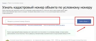
- find out the correct information about the location address and other parameters of the property by cadastral number;
- if you need to find out the cadastral number of an apartment, get other information by selecting an object on the map of our country;
- obtain information about whether the property has encumbrances;
- check if there are any errors in the data about the property and make a request to have them corrected by Rosreestr.
Usually, to check the legal purity of a transaction, the information contained in the public cadastral map is sufficient; this is important when you are going to conclude a transaction to purchase real estate. The buyer can check whether there are encumbrances on the apartment and whether it is pledged. This will save your time and help when drawing up documents for purchasing an apartment.
Tax calculation
Tax obligations and payments for a specific property are calculated based on information about the cadastral value. The cadastral value can also be found from the Rosreestr map. The owner of the apartment can challenge the information received through a lawsuit or with the help of a special commission.
Process
If, when checking the information obtained from the public cadastral map, you find errors in the data, then, as apartment owners, you can do the following:
- if there is a technical error, you need to contact the Rosreestr office so that clarifications can be made;
- If the error occurs after the cadastral work has been carried out, then you should contact a cadastral engineer so that additional clarifying work can be carried out, and to eliminate the violations, you may need to go through the cadastral registration again.
Using the public cadastral map, you can obtain up-to-date information and also request an extract from the Unified State Register of Real Estate. You need to mark the property on the map or enter the search data in the appropriate form. The response will be generated as a written document or as an electronic file.
If you need information about a plot of land
A plot that is still in municipal ownership, or while a new property is being formed, there will be no information about them in the public cadastral map. In such a situation, you can only look at the location of this object, and information about it will appear in the general database only after registration of ownership rights and after the cadastral registration procedure.
You can obtain the information that is on the cadastral resource portal in any locality in our country. The database is constantly updated, this happens after the rights to real estate are registered and cadastral registration is carried out. This is reflected in the public cadastral map.
Posuslug website of Rosreestr
You can find the path to the public cadastral map through the public services portal of the Rosreestr website.
This means that if you use a public cadastral map, you can find out about the districts and cadastre areas, blocks and cadastre sections. Cadastre plots are the smallest components of the cadastre; they are the border of land plots of shareholders in the SNT. This service is most often used by lawyers, realtors, surveyors, and receives the information they need for their work.
Where and how to apply?
In order to enter your land property into the state real estate cadastre, you must contact the cadastral chamber or the Multifunctional Center (MFC) in the same locality as the registered object. To submit an application, you must have certain documents with you:
- passport of a citizen of the Russian Federation (if the registering person is an individual);
- constituent documents (if the registering party is a legal entity);
- application (provided along with a sample form at the cadastral chamber/MFC);
- receipt of payment of the state duty (the amount can be clarified in the bank where it is paid);
- documents confirming the right to the property in question;
- boundary, geodetic plan (for land plots);
- technical passport (for registration of houses);
- consent of the ministry/committee for property management (when registering a municipal/state facility);
- consent of the guardianship authorities (if necessary).

Important! When registering a privately owned property, you should consider the following:
- if the owner registers, but the property has tenants, then their written consent is required;
- If tenants register, then the written consent of the owner is required.
You should contact the cadastral office for samples.
Cadastre - what is it?
Let us immediately make a reservation that cadastre is a polysemantic term. Let us note, however, that most often this word refers to a system of information about certain objects of taxation.
A cadastre can also be called a systematized collection in general, containing ordered data about something. The cadastre is also understood as a specialized, systematized database, which is compiled periodically or through regular observations of a particular object. Accordingly, they distinguish land, water, forest cadastre, cadastre of mineral deposits, etc.
The state cadastre is understood as a single, officially compiled register, which is a systematic collection of data on the economic resources that the country and the state have. The information contained in the cadastre is the basis for calculating the amount of taxes associated with certain objects (buildings, land, industries, etc.).
The compilation of such codes is carried out by the federal cadastre service, which carries out periodic or regular monitoring of objects. The information contained in the cadastre makes it possible to estimate the cost and average profitability of objects for making transactions with them (rent, purchase and sale, pledge, etc.).
The cadastre displays information about the location of sources of resources and objects. Their size, quality characteristics, including cost and profitability are indicated.
The most famous is the land cadastre. At the same time, there are also less popular cadastres: groundwater, individual fisheries, wind cadastre, etc. It must be admitted that without a cadastre, effective public administration is hardly possible: you cannot correctly manage what you do not know. Therefore, governments of different countries do not spare money on maintaining cadastres. This is an integral part of politics.
One cannot fail to mention the state real estate cadastre, which contains a detailed list of real estate objects. The cadastre displays dividing lines between the boundaries of states, neighboring regions, municipalities and other zones. Data entry into the cadastre is carried out by a cadastral engineer, whose powers are supported by the corresponding cadastral certificate.
One of the responsibilities of an engineer is to prepare the necessary documents to keep records of the object and record it in the cadastre.
Cadastral registration is the prerogative of the Federal Cadastral Registration Service, which also deals with cartography. Maintaining a unified cadastre requires a high degree of coordination of the actions of individual services in different regions. In order for the cadastre to always correspond to reality, it must be updated periodically. The information that is entered into the cadastre is carefully double-checked: it must exactly correspond to the data contained in other documents. Cadastral documents must be carefully stored. Their destruction is excluded.
The presence of a cadastre allows you to quickly identify any property and establish its characteristics.
Receipt procedure
Important! When submitting documents, you must bring originals (a copy will be made of them and they will be returned immediately) or notarized copies.
An employee of the cadastral chamber or MFC will accept the documents, issue a receipt with a list of those accepted and set a date for receiving the finished document.
It takes 18 days to issue a cadastral passport if the documents are submitted to the cadastral chamber, or 20 - 25 days if to the MFC.

After this period, a passport or extract is issued confirming the inclusion of the property in the state real estate cadastre.
If a division or allotment of an object is made, all parts must be registered at the same time, because at the same time the process of cessation of the existence of the divisible property also occurs. If the registered land (structure) is not registered, then temporary registration is issued for a period of two years. During this period, rights to the object must be registered. If the rights are not formalized within the specified period, the plot is canceled.
Results
Also, using a public cadastral map, you can find out the legal status of a plot of land, its address, the area of the property, how much is the cadastral price of the property, what is the form of ownership of the property of its owner. Such data is necessary in order to make a cadastral passport and other documents for the land.
To obtain an extract from the real estate register, you need to enter several search parameters into the system, namely: address, cadastre number. After this, a table with a Unified State Register link will be generated for you. The data can be printed or left electronically.
Issuance of a certificate
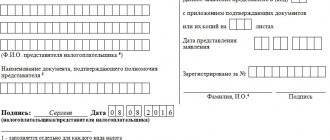
After registration in the real estate cadastre has been confirmed through receipt of a passport, you should submit an application to Rosreestr and receive a certificate of registered property. The following list of documents is required to be provided:
- application (a sample can be found on the Rosreestr website);
- cadastral passport;
- boundary (land plot) or technical (construction) plans;
- document confirming the right to own real estate;
- confirmation of government payment duties (receipt);
- passport (if an individual applies) / constituent documents (if a legal entity applies).
As in the case of a passport, you can take the documents to both the registration service and the MFC.
The nuances of each of the cadastral registration procedures, the necessary documents
In order to enter a site into the cadastral register, it is necessary to draw up its plan. You won't be able to do this yourself. The specialist who carries out this work is a cadastral engineer. His tasks include determining the exact area of the site, land surveying, determining the condition and purpose of the land.
Features of registration
As we have already mentioned, the staging process begins with calling cadastral services. The next step is the preparation of all the necessary documents, which you will submit to Rosreestr or the multifunctional public services center (MFC).
Most of the papers will be collected by the cadastral specialist by contacting the relevant services. However, you will have to prepare a number of documents.
These include:
- documents confirming land ownership;
- a copy of the power of attorney in case the documents for registration of the property will be submitted not by the owner of the property, but by his authorized representative;
- court decisions (if any);
- application of the appropriate sample.
The cadastral engineer will prepare for you a boundary plan of the land plot, as well as documents confirming that the plot belongs to a certain category of land, and permission to use it.
Next, you submit documents to Rosreestr directly or through the MFC. When you make a successful decision on your land, you will receive an extract from the Unified State Register of Real Estate (USRN) for your property.
Alteration
The main reason for making changes to the cadastral register is a change in the owner of the plot. This happens when selling, donating, or inheriting.
In this case, the participants in the transaction during which the transfer of ownership took place must contact Rosreestr and provide the relevant transaction agreement, as well as documents recording the rights of the new owner of the land.
Do not forget that in this case you will have to pay a fee. As a result, you will receive an extract from the Unified State Register of Real Estate with updated information about the land allotment.
Removal from the register
It is possible to remove land from cadastral registration if it is divided into two or more plots, as well as in the process of land redistribution.
The main document required for this procedure is the survey report. A cadastral specialist will be able to prepare this paper for you during an inspection of your plot.
Next, you need to contact Rosreestr or the MFC with a package of papers, which will also include a document confirming ownership and an application to exclude your land from the state register. Don't forget to take your passport - or power of attorney if you are not the owner of the land.
Refusal and its consequences
Here are a few reasons why registration may be denied:
- incorrectly formalized powers of the applicant;
- legal impossibility of registering real estate;
- the object subject to registration is not real estate;
- real estate is formed through the connection of lands that cannot be combined (for example, due to different purposes);
- there is no approach to the registered object;
- the land plot extends beyond the boundaries of the populated area;
- incorrectly executed documents;
- incomplete list of documents provided.
As stated above, it takes 18 - 25 days to determine the possibility of registration. After this, in case of refusal, the applicant will be given a written decision indicating the reason for the refusal. You should eliminate the problem and re-apply or, in case of disagreement, appeal the refusal in court.
It is also possible not to refuse, but to suspend registration. The reason for this is usually inconsistency of documents or errors in them. You are given three months to correct it, otherwise you will have to submit everything again.