Home / Real estate / Land / Land survey / Boundaries of the land / Changing the boundaries of the land
Back
Published: March 18, 2017
Reading time: 15 min
0
1314
The imposition of boundaries for owners of adjacent plots is a serious problem that complicates the use of the plot and complicates operations with it.
Elimination of this problem can be achieved either by a peaceful agreement with neighbors or by going to court - depending on the reasons for which the overlap arose.
- When boundary overlap occurs
- Pre-trial settlement
- Error in the cadastral chamber
- Cadastral engineer's error
- Unauthorized border transfer
- Landscape changes
- Going to court
- Drawing up an application
When boundary overlap occurs
By overlapping boundaries we mean the mutual intersection of the boundary lines of adjacent plots of land, when the same small plot is located within the boundaries of two or more neighboring plots.
There are two main types of border imposition:
- Imposing natural boundaries;
- Overlay in boundary (cadastral) documents.
In the first case, the imposition manifests itself in the form of the seizure of part of the land of a neighbor (a private individual or a municipality) through the unauthorized transfer of the boundary, allocated in kind, without fixing it in the boundary plans of the plots.
The second type of overlap occurs during land surveying, when the cadastral engineer’s calculations require moving the customer’s boundaries towards the neighbor, whose site is indicated on the cadastral plan of the territory. The reasons for the occurrence of overlapping boundaries on the cadastral map may be the following:

- Error in the cadastral worker's measurements;
- An error in the calculations of the geodetic company that carried out the survey;
- Entering erroneous data into the state real estate cadastre;
- Changing the landscape of the area.
When the generated boundary plan is sent for approval to the cadastral authority, its employees check the submitted calculations for the plan and in some cases make adjustments that may be incorrect (this is the most difficult type of error to detect).
If the boundary points are tied to terrain elements, then changing it can also lead to overlap!
What to do if the overlap of plot boundaries occurred due to an error in the Unified State Register of Real Estate
If there is a discrepancy between the data contained in the Unified State Register and the data that was obtained by the cadastral specialist during the last land surveying work, be sure to contact the Unified State Register by submitting an application and a number of the following documents:
- A photocopy of your passport;
- Documents establishing your rights to land;
- Documents confirming your authority;
- Extract;
- A copy of the part of the land surveying project where your site is located;
- Conclusion of the cadastral engineer on the condition of the boundaries of the plots.
Be sure to attach to the conclusion information about the specialist who carried out the land surveying work, and a copy of his license giving the right to carry out such work.
The period established for consideration of the application by the cadastral authority is 30 days. After this period, you will receive either a refusal to correct or a decision to correct. Do not forget that the refusal must be in writing and justified. After that, go to court.
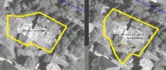
Overlay of plots on the cadastral map.
Read about determining the boundaries of a site on the ground here.
Read about disputes regarding the establishment of land boundaries at the following link:
Pre-trial settlement
If during boundary work it is discovered that borders overlap, it is first necessary to establish the reason for such overlap.
To do this, you need to take the following steps:

- Contact the cadastral chamber to obtain a cadastral extract on the boundaries of the plot;
- Request a certificate of boundaries from the territory surveying project;
- Order a recalculation of the data measured by the cadastral engineer;
- Ask your neighbor to present a boundary plan or (if there is no plan) a cadastral passport.
When applying to the cadastral authority for an extract, you must present a passport and a certificate of right to use the plot. The extract must be provided within 10 days.
What to do if land boundaries overlap during land surveying
If overlapping boundaries are detected, be sure to establish the reason for this overlap.
Carry out a number of the following actions:
- Contact the cadastral chamber to obtain an extract containing information about the boundaries of the site;
- Request a certificate from the survey project containing information about the boundaries of the site;
- Order a recalculation of the data that was measured by a specialist;
- Obtain a site plan from the person who owns the neighboring plot.
When applying for an extract, be sure to present your passport and the corresponding certificate for the site. The deadline for providing an extract is ten days.
Error in the cadastral chamber
If it turns out that the information contained in the state real estate cadastre (GKN) differs from the data received by the cadastral worker during the last survey, then you must contact the State Real Estate Cadastre with an application to correct the error, attaching the following documents to the application:

- A copy of the applicant's passport;
- Title documents for the plot of land;
- Legal documents;
- Previously received extract;
- A copy of part of the land surveying project with the applicant’s site;
- Conclusion of the cadastral specialist on the state of the borders.
The conclusion must be accompanied by information about the cadastral engineer who carried out the measurements and calculations, as well as a copy of his license to carry out geodetic work.
The cadastral authority is obliged to consider the application within thirty days and correct the error or refuse to correct it.
If the State Tax Committee refuses to correct the error, you must request a written refusal indicating the reason, and then go to court.
What is a land boundary overlay?
If the configuration of the plots does not have a clearly defined geometric shape, problems associated with defining boundaries may arise. The same thing arises if one of the owners illegally seized a nearby part of the plot, moving the remaining plots to the side.
Sometimes overlap of boundaries occurs as a result of a cadastral error and exists only in the documentation of the state real estate cadastre (GKN), acquiring discrepancies with the actual state of affairs.
When superimposed, boundary boundaries lose their actual position and move to the right or left, back or forward. The legal consequence of the precedent becomes:
- violation of information entered into Rosreestr;
- the possibility of violating the property rights of neighbors;
- admissibility of infringement of one's own property rights.
Naturally, if one landowner illegally increased his allotment, the other right holder’s allotment will decrease . But the main danger in this regard is the loss of legal capacity of a capital structure, which must be built in accordance with the “red line” regulations.
Cadastral engineer's error
There are often cases where an overlay occurs due to errors by a cadastral engineer.
It must be remembered that the cadastral engineer, according to Art. 29 Federal Law “On Cadastral Activities”, must meet the following requirements:

- Be in the federal register of cadastral engineers;
- Have the appropriate license;
- Have a higher education in the field;
- Previously worked for at least 2 years as an assistant to a cadastral worker;
- Have a cadastral worker's liability insurance policy.
If the cadastral engineer does not meet these requirements, then the customer has the right to demand compensation from the geodetic company and carry out the work again, or contact another geodetic company.
If company employees made mistakes in their calculations, they can be corrected by engaging an independent expert.
If there are errors in measurements, the entire site will have to be surveyed again, which will incur significant costs.
If the new survey confirms previously made geodetic errors, then the customer has the right to recover costs in court.
What to do if the overlap of plot boundaries occurred due to a cadastral engineer’s error
In practice, there are often situations in which the imposition is a consequence of an error by the cadastral engineer.
It should be noted that in accordance with Article 29 of the Federal Law “On Cadastral Activities” the following requirements are imposed on the cadastral engineer:
- He must have the appropriate license;
- He must have an appropriate higher education;
- He must be included in the federal register of these specialists;
- He must have at least two years of experience as an assistant cadastral engineer;
- He must have liability insurance.
If a specialist does not meet the requirements listed above, you have the right to demand compensation for damages from the company that carried out the work. In addition, you may request that the work be done again.
If cadastral specialists make an error in the calculations, you have the right to use the services of an independent expert. Errors in measurements entail the need to carry out new land surveying work on the site, which requires additional costs.
If errors are confirmed after new land surveying work, you have the right to recover costs through the court.
Unauthorized border transfer
If the owner of a plot has discovered an unauthorized seizure of part of his territory by a neighbor by moving the fence during land surveying, then the algorithm of actions is as follows:

- Request the neighbor to present a boundary plan or cadastral extract indicating the boundaries of his plot;
- Submit a copy of your neighbor’s boundary plan and your own boundary plan to the State Committee for Taxation with a request to correct the error;
- If a neighbor refuses to present documents regarding boundaries, conduct a land survey on your property;
- Notify the neighbor about the need to coordinate boundaries in accordance with paragraph 1 of Art. 39 Federal Law No. 221;
- If you refuse to sign an agreement or fail to appear at a meeting, notify your neighbor of responsibility for his actions;
- If there is further resistance to a peaceful settlement, go to court.
Often, when voicing responsibility for unauthorized seizure of land, according to Art. 7.1 of the Code of Administrative Offenses of the Russian Federation, which implies a fine of at least 5,000 rubles, the neighboring land user agrees to restore the boundaries in accordance with the boundary plan.
To coordinate the boundaries, it is necessary to announce to all interested parties about the meeting by agreement, and notify them of this no earlier than ten days before the meeting.
If you refuse to put your signature on the approval act, the interested person must provide a written, reasoned objection to the initiator of the meeting.
You can also enter into an agreement with your neighbor to conduct an independent land survey to eliminate the overlap, based on objective data. Such an examination is carried out by a geodetic company, carrying out survey work in the area of adjacent boundaries where the overlap has arisen, since such a service is much cheaper than surveying both disputed plots.
Unauthorized transfer of site boundaries
More often, neighbors violate the boundaries reflected in the documentation. This may not be related to the culprit's intention to seize someone else's property. It is possible that minor errors were made during the construction of the barrier, resulting in land overlap.
Remember! If an actual overlap of land is discovered, the generally established principle should be followed:
- try to negotiate with your neighbor. It is quite possible that he did not know about the “land grab”. Ask him to eliminate the shortcomings within a certain period of time. It is better to draw up a written agreement that details the problem and the deadline for its elimination;
- if a neighbor refuses to voluntarily eliminate deficiencies, it is worth providing him with a copy of the land plot plan, which shows the boundaries. The document is handed over under the signature of the culprit. To do this, you should draw up a special document on the transfer of a copy of the land survey plan;
- At the same time as providing a copy of the plan, you should ask the neighbor for his demarcation document. The culprit should be warned about the civil obligation described in Federal Law of the Russian Federation No. 221 “On Cadastral Activities” dated July 24, 2007, which concerns the preliminary approval of boundaries without the involvement of authorities;
- In any case, it is necessary to draw up an act of coordination of boundaries. If a neighbor refuses to sign it, this must be reflected in the document;
- If, after taking the above actions, the neighbor still refuses to resolve the conflict peacefully, you can go to court. In this case, it is worth providing all the documents indicating an attempt at peaceful reconciliation.
ATTENTION! Look at the completed sample act of approving the location of the boundaries of the land plot:
Unauthorized seizure of land is subject to administrative liability in accordance with the Code of Administrative Offenses - Article 7.1. According to it, the culprit will receive a minimum punishment in the form of a fine equal to five thousand rubles.
More often, after voicing responsibility and presenting a detailed plan of the land plot, the neighbor agrees to resolve the conflict voluntarily. It becomes more difficult if both neighbors are confident that they are right. This happens due to errors in the documentation.
Before coordinating the definition of the boundaries of a land plot, it is worth notifying your neighbor of your intention at least ten days before the event. If a neighbor refuses to sign the agreement, he must justify his refusal in a special document.
However, providing this to the court is not necessary to restore the legal rights of the victim. The injured party has the opportunity to agree with the culprit to conduct an independent examination, which will determine the boundaries of the plots.
A licensed company has the right to carry out the examination. Their full list can be found on the official website of the cadastral chamber.
Please note that defining boundaries costs much less than land surveying.
Watch the video. Correction of overlapping boundaries of non-adjacent land plots:
Landscape changes
If the survey was carried out five or more years ago, when boundary turning points were often tied to natural elements of the landscape, as a given landscape changes over time, the boundary points shift, which leads to the imposition of boundaries.
Currently, during boundary work, boundary points are set using GPS beacons, which eliminates their dependence on soil changes.
To eliminate overlaps due to landscape changes, it is necessary to clarify the boundaries using modern technical means.
Going to court
If pre-trial actions have not changed the situation, it is necessary to apply to the arbitration court at the location of the plots of land, the boundaries of which have become the subject of disputes.
Before going to court, you must collect the following documents and certificates:

- A copy of the applicant-plaintiff's passport;
- Receipt for payment of court fees;
- Title documents for the plaintiff’s land plot;
- Certificate of ownership of land plot;
- Cadastral passport of the allotment;
- A copy of all pages of the boundary plan;
- Cadastral extract from the State Property Committee on boundaries;
- Conclusion of a cadastral specialist;
- Land survey data;
- Certificates and checks regarding expenses for pre-trial resolution of the issue;
- Other documents confirming the pre-trial actions of the plaintiff.
The latter may include the refusal of the cadastral authority to correct an error in the cadastral map of the area, the refusal of the owner of a neighboring plot to carry out/coordinate land surveying, etc.
Legal documents include documents that served as the basis for registration of ownership of a plot of land:
- Agreement of purchase, gift, exchange;
- Certificate of inheritance rights;
- The administration's decision to grant ownership of the plot.
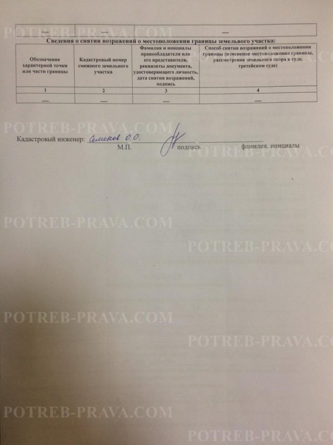
Among the copy pages of the boundary plan there must be an approval act

survey work (it is located on the back of the graphic part of the survey document).
If the neighboring owner was absent from the meeting of interested parties, it is necessary to present to the court the minutes of the meeting, where the absence of this person will be indicated, then the land survey is considered agreed upon, in accordance with paragraph 3 of Art. 40 Federal Law “On cadastral activities”.
The plaintiff needs to be prepared for the fact that the defendant may claim untimely notification of a meeting of interested parties, so it is necessary to provide evidence of timely notification (for example, an announcement in the print media).
Certificates of expenses incurred are necessary for compensation of losses and as additional evidence of pre-trial activities carried out.
The list of documents may be supplemented depending on the specific circumstances of the case.
Not only the state, but also an individual has the right to lease agricultural land. What is a state housing certificate, why is it needed and how to get it? You will find the answer to all these questions in our article.
Are you planning to buy an apartment in the Krasnodar region? All important details are described here.
The procedure for filing and considering a claim in court, correctly drawing up an application, collecting documents
Before going to court, you should collect the necessary package of documents confirming the plaintiff’s arguments. Copies should be made of the collected papers in advance. Mandatory documents attached to the application include:
- title documentation for land;
- official conclusion from the cadastral engineer;
- cadastral extract with indicated boundaries of plots;
- written refusal from the state cadastre;
- a copy of a letter to a neighbor - a land user with a proposal to resolve the situation peacefully (there is no special sample, the style is free);
- a copy of the passport of the person filing the claim.
If at least one of the listed documents is missing, the court will return the claim to its submitter without consideration.
The contents of the application must include:
- Information about the landowner with whom the boundary overlap was identified.
- Information about the impossibility of resolving the problematic issue with the specified owner (defendant) peacefully (papers are attached indicating the plaintiff’s intention to resolve the issue amicably, as well as the responses of the defendant refusing to satisfy this request).
- Information about the plaintiff’s land plot indicating its location on the map, dimensions and other characteristics.

Third parties, namely state cadastre and administration bodies, may be involved in judicial review. Information about them should also be reflected in the statement of claim, asking the court to involve them in the consideration of the case. Also, several owners of adjacent plots may take part in the process.
A signed and dated statement of claim, as well as documents attached to it, should be prepared in a quantity corresponding to the number of persons participating in the process.
During the court hearing, in addition to the documents provided, it is allowed to refer to witnesses and eyewitnesses who can confirm the essence of the violations of the plaintiff’s rights that arose as a result of the mistake.
A feature of the consideration of such claims is that the court has the right to involve other persons in the process if it is determined that their rights are also affected.
A court hearing is different in that there are no guilty parties present. The legislator does not connect the violation of boundary boundaries with the intentional actions of any individuals. In its proceedings, the court considers the issue of challenging the passive actions of officials who refuse to resolve the conflict that has arisen. The plaintiff is faced with the task of proving not the guilt of some individuals, but the need to urgently eliminate the existing error.
The duration of the trial, according to the established procedure, is two months (but this does not mean that the case cannot be considered on its merits before the specified time). After this period, the court makes one of two relevant decisions:
- satisfying the stated claims;
- refusing to satisfy the claim.
When many involved persons whose rights have been violated participate in the trial, the process may unintentionally be delayed for some period of time. This circumstance is caused by an objective necessity, since it is necessary to evaluate the arguments of a significant number of people.