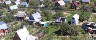
Redistribution of land plots in 2020
Redistribution of land plots may be required for various reasons. Most often these are problems that can only be eliminated in this way:
- broken border line;
- wedging of adjacent areas;
- communications supply;
- inconvenient approach or entrance, etc.
When several contiguous land plots are redistributed, several other contiguous land plots are formed, and the existence of the original contiguous land plots ceases.
This is enshrined in Article 11.7 of the Land Code of the Russian Federation.
In this case, an unlimited number of areas can participate in the procedure. And all of them eventually cease to exist as independent objects of civil rights, and new ones are formed in their place.
The redistribution of land plots is regulated by Article 11.2 of the Land Code. Special rules apply if the redistribution procedure involves artificially created land or if, as a result of redistribution, multi-circuit areas are created.
Plots formed as a result of redistribution must comply with the general requirements specified in Article 11.9 of the Land Code of the Russian Federation:
- The maximum dimensions of the created plots must comply with urban planning regulations, if these regulations are provided for by law.
- The boundaries of land plots should not cross the boundaries of municipalities and (or) the boundaries of settlements, territorial zones, forest areas, forest parks.
- The formation of new land plots should not infringe on the rights of property owners located on the original plots, as well as other rights holders.
- The formation of land plots should not lead to wedging, interspersing, broken boundaries, interstriations, the impossibility of placing real estate objects and other shortcomings that impede the rational use and protection of land.
In addition to the Land Code of the Russian Federation, the process of redistribution of land plots is regulated by relevant law No. 78 “On Land Management” and many government and departmental by-laws.
Redistribution of land between owners of adjacent plots
Features of redistribution:
- Only adjacent areas can be redistributed.
- During redistribution, new plots are formed, which will be assigned a new cadastral number. The redistribution procedure is regulated by the norms of the law on the formation of plots (Articles 11.2-11.10 of the Land Code of the Russian Federation, as well as Federal Law No. 218-FZ of July 13, 2020, regulating the accounting and registration of real estate). It is important to understand that this is not just about changing part of the boundaries of existing plots, but about the formation of new plots for which there will be updated packages of documents.
- The original plots cease to exist, and the right to them is extinguished.
- The owners register the right to the created plots.
- The areas resulting from redistribution must be reassigned addresses by contacting the authorized authority through the MFC.
- Redistribution of plots is possible if the original plots have land surveying. In the absence of clarification of the boundaries of the areas being converted, it is necessary to first carry out land surveying and then prepare for redistribution.
Link to document:
Link to document:
The procedure for redistribution of land plots
Land plots are redistributed in accordance with the procedure specified by law. In order to do this, you must complete the following steps:
- All owners of redistributed land plots must enter into an agreement on the redistribution of their lands (regardless of whether private plots or municipal plots)
- All owners of such plots must prepare the necessary documents for submission to the MFC or other body providing the service
- You must complete an application and submit it to the MFC
- The authorized body issues a resolution on the redistribution of areas (if plots with municipal lands are redistributed)
- The cadastral engineer carries out all the necessary boundary work, including geo-surveying and registration of the boundary file, in accordance with the general cadastral scheme
- Next, new lands are registered with Rosreestr. That is, the plots receive an individual number, a passport is issued, and information about the areas is entered into the State Property Committee, a protocol for the formation of new land zones
- At the final stage, ownership rights to the plots are registered for each owner
At different stages of the procedure, redistribution is carried out by land owners, surveyors and Rosreestr employees. Like all other methods of creating new plots, the redistribution procedure can take at least two months .
Redistribution of private land plots
To receive services to individuals or legal entities through the MFC, the following documents are required:
1. Application for redistribution of land and (or) land plot (approved form (generated electronically when receiving documents, original 1 pc.)
2. Layout of the land plot (In the event that the requested land plot is to be formed and there is no project for surveying the territory within the boundaries of which the redistribution of land plots is carried out, Original 2 copies, 1 copy is returned)
3. A copy of the territory surveying project and the decision on its approval (In case the requested land plot is to be redistributed in accordance with the territory surveying project, a notarized copy or a copy with presentation of the original 1 piece, provided without return)
4. A copy of the identity document of the applicant (applicants), who is an individual, or the identity of a representative of an individual or legal entity (Passport of a citizen of the Russian Federation or passport of a foreign citizen 1 piece, provided without return).
5. A copy of a document certifying the rights (powers) of a representative of an individual or legal entity (a notarized copy or a copy with the presentation of the original 1 pc., is provided without return if the application is submitted by a representative of the applicant (applicants).
6. Certified translation into Russian of documents on state registration of a legal entity in accordance with the legislation of a foreign state (1 notarized copy, provided without return if the applicant is a foreign legal entity).
7. Constituent documents (Notarized copy or copy with presentation of the original 1 copy, provided without return for legal entities).
8. Extract from the Unified State Register of Rights to buildings and structures located on the redistributed land plot (Provided without return, if there are buildings, structures on the land plot. Validity period - 1 month, original 1 piece).
8.1. Notification about the absence in the Unified State Register of the requested information on registered rights to the specified buildings, structures (Provided without return If there are buildings, structures on the land plot, if the right to such a building, structure is not registered in the Unified State Register, but in accordance with the law is recognized as having arisen regardless of its registration Validity period – 1 month, original 1 pc.,).
9. Extract from the Unified State Register of Rights to the redistributed land plot (Provided without return. Validity period - 1 month, original 1 piece).
9.1. Notification about the absence of the requested information on registered rights to the specified land plot in the Unified State Register (Provided without return. Validity period - 1 month, original 1 piece).
9.2. Copies of title or title documents for the land plot owned by the applicant (Notarized copy or copy with presentation of the original 1 pc., Provided without return If the right to such land plot is not registered in the Unified State Register).
10. Cadastral passport of the original land plot (Original 1 piece, provided without return).
10.1. Cadastral extract about the original land plot (Original 1 piece, provided without return).
11. Cadastral passport of the premises, building, structure located on the original land plot (Notarized copy or copy with presentation of the original 1 piece, provided without return).
12. Consent of land users, landowners, tenants, mortgagees of the original land plots (Original 1 piece, provided without return).
Documents specified in paragraphs 3, 7, 8, 8.1, 9, 9.1, 10, 10.1, 11
The list cannot be requested from the applicant; however,
at the request of the applicant, they can be submitted along with the application.
This service is provided free of charge. The period for provision is 30 days.
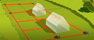
What does a sample land plot plan look like?
In the boundary plan in accordance with Part 2 of Art. 22 of Law No. 218 provides the following information:
- information about the site(s) formed as a result of the work;
- information about part or parts of the site;
- new data that must be entered into the Unified State Register.
The document form was approved by Order of the Ministry of Economic Development dated December 8, 2015 No. 921 and consists of graphic and text parts. The graphic displays the boundaries of the allotment, and the text displays its description, which is necessary for inclusion in the Register.
Sample boundary plan for redistribution of adjacent land plots - download.
Examples of a boundary plan in pdf format:
- sample boundary plan for the redistribution of land and municipally owned lands - download;
- sample boundary plan for combining land plots into one - download;
- sample boundary plan for dividing a land plot - download;
- sample boundary plan for dividing a land plot while preserving the original one - download.
Still have questions? Find out how to solve your particular problem - call the hotline right now or write to our consultant.
8 (Saint Petersburg)
Redistribution of land plots is a type of cadastral work in which several other adjacent land plots are formed from several adjacent land plots. When redistributing lands and a land plot, the existence of the original land plot ceases and a new land plot is formed. When redistributing privately owned land plots, their owners acquire ownership rights to the corresponding land plots being formed in accordance with agreements between such owners on the formation of land plots.
There are several cases of redistribution:
- The redistributed land plots are privately owned, and the boundaries of which are established in accordance with current legislation;
- The redistributed lands and (or) land plots are in state or municipal ownership;
- One redistributed land plot and (or) land is in state or municipal ownership and one land plot is in private ownership.
Requirements for the original redistributed land plots that are privately owned:
- the redistributed land plots must be adjacent;
- the boundaries of the original redistributed land plots must be established in accordance with the requirements of the current legislation, namely, land surveying was carried out in relation to them;
- redistributed land plots must have the same category of land and type of permitted use;
- the redistributed land plots must be located in the same municipality;
- Access to land plots obtained as a result of redistribution must be ensured. Access can be achieved either through public lands or through the establishment of an easement;
- When redistributing land plots, an agreement, a protocol on the redistribution of land plots from land users, landowners, tenants, and mortgagees is required.
Cadastral work on the redistribution of land plots includes:
- study by a cadastral engineer of title documents for the original redistributed land plots;
- ordering information from the GKN (State Real Estate Cadastre) - cadastral extracts for the original land plots, as well as the CPT (cadastral plan of the territory) and extracts from the Unified State Register of Rights;
- assessment of the situation in neighboring areas based on information received from the State Property Committee to eliminate cadastral errors that affect the conduct of cadastral work, for example, crossing borders with neighboring land plots; the accuracy of determining characteristic points is also clarified;
- agreement with the Customer on the need for field work - the departure of a geodetic team for geodetic measurements of the expected actual boundaries of land plots, which should result from the redistribution of the original land plots;
- geodetic measurements of the supposed actual boundaries of land plots, which should be obtained as a result of the redistribution of the original land plots, fixing turning points with boundary signs;
- drawing out options for redistribution of land plots based on the wishes of the Customer and (or) based on the results of field work;
- drawing up a protocol and signing it by land users, landowners, tenants, mortgagees;
- formation of a boundary plan and its coordination with the Customer of the work;
- submission of the boundary plan for verification to the cadastral registration authority;
- obtaining cadastral passports for established land plots.
Redistribution of land plots with municipal land
If the owner (citizen or legal entity) of a plot needs to conclude an agreement on the redistribution of land plots that are in state or municipal ownership and land plots, then he must apply for the redistribution of such land plots to the authorized body.
The authorized body, depending on the ownership of the land, may be:
- local administrations
- property relations committees
- Ministry of Property Relations and Land Resources
Conclusion of an agreement on the redistribution of land plots
In order to conclude an agreement on the redistribution of land plots it is necessary:
- correctly draw up an application for redistribution;
- attach the necessary documents;
- submit the application and necessary documents properly,
- wait for the result (no more than 30 days from the date the application was received by the authorities).
First things first. Let's start by drawing up an application.
The application for redistribution of land plots must indicate:
1) last name, first name and (if any) patronymic, place of residence of the applicant, details of the applicant’s identity document (for a citizen);
2) the name and location of the applicant (for a legal entity), as well as the state registration number of the entry on state registration of a legal entity in the unified state register of legal entities, taxpayer identification number, except for cases where the applicant is a foreign legal entity;
3) cadastral number of the land plot or cadastral numbers of land plots, the redistribution of which is planned to be carried out;
4) details of the approved land surveying project, if the redistribution of land plots is planned to be carried out in accordance with this project;
5) postal address and (or) email address for contacting the applicant.
Sample application for redistribution of land plots
Sample application for redistribution of land plots
The application for redistribution of land plots is accompanied by:
1) copies of title or title documents for the land plot owned by the applicant, if the ownership is not registered in the Unified State Register of Real Estate;
2) the layout of the land plot in the event that there is no land surveying project for the territory within the boundaries of which the redistribution of land plots is carried out;
3) a document confirming the authority of the applicant’s representative, if the application for the provision of a land plot is submitted by the applicant’s representative;
4) a certified translation into Russian of documents on state registration of a legal entity in accordance with the legislation of a foreign state if the applicant is a foreign legal entity.
How can an application be submitted when concluding an agreement on the redistribution of land plots?
- Personally
- Postal service
- MFC (not in all regions)
- Electronically, via the Internet (for example, the portal of the Moscow Mayor, but not in all regions)
The procedure and methods for filing applications for the redistribution of land plots, if they are submitted in the form of electronic documents using the Internet information and telecommunications network, the requirements for their format are approved by the federal executive body authorized by the Government of the Russian Federation.
What could be the result of submitting an application?
The authorized body, within 30-35 days after receiving your application for redistribution of land plots, can:
- Make a decision to approve the layout of the land plot and send you this decision with the specified diagram attached;
- Send you consent to conclude an agreement on the redistribution of land plots in accordance with the approved land surveying project;
- Refuse to conclude an agreement if there are grounds specified by the Land Code (clause 9 of Article 39.28 of the Land Code of the Russian Federation).
Within no more than thirty days from the date of submission to the authorized body of the cadastral passport of the land plot or land plots formed as a result of redistribution, the authorized body sends signed copies of the draft agreement on the redistribution of land plots to the applicant for signing. The applicant is required to sign this agreement no later than thirty days from the date of its receipt.
The authorized body refuses to conclude an agreement on the redistribution of land plots if the area of the land plot to which the right of private ownership arises exceeds the area of such land plot indicated in the land plot location plan or the territory survey project, in accordance with which such land plot was educated, more than ten percent.
Land redistribution
Land plots owned by citizens and legal entities require proper registration during redistribution.
Registration procedure. Agreement between owners (sample)
The redistribution of adjacent territories belonging to individuals and enterprises occurs in several stages (Article 39.29 of the Land Code of the Russian Federation):
- owners' appeal to the executive body whose competence includes agreement on redistribution with an application (indicating information about the owners and plots);
- consideration of the application by the authorized municipal body;
- making a decision (resolution) on consent or refusal to redistribute (consent is carried out simultaneously with the approval of the scheme for the location of the redistributed lands).
The redistribution agreement, drawn up in simple written form, must contain:
- information about the owners (indicating all the necessary details);
- information about land (category, purpose, plot size, cadastral number);
- way of forming a new territory.
Redistribution of municipally owned lands
If the disputed lands are in municipal ownership, their redistribution differs in some nuances.
List of documents for the municipal authority
To redistribute land, you must submit:
- agreement on the redistribution of plots (indicating information about the owners, details of the parties, registration data, with a detailed description of the territories);
- statement from one of the parties to the agreement;
- a copy of the applicant’s passport (representative by power of attorney);
- boundary plan;
- protocol for approving land redistribution;
- resolution on redistribution;
- cadastral information;
- title documents.
If the plots are owned by the same municipality, the redistribution will be carried out on the basis of its decision.
Review period
The application for redistribution is considered by the municipal body within 30 days in accordance with Part 8 of Art. 39.29 of the Land Code of the Russian Federation.
In this case, the established period for consideration of the application may be increased to 45 calendar days in the absence of agreement on the land layout with the executive authority.
In case of failure to comply with the requirements of Art. 39.29 of the Land Code of the Russian Federation, the absence of any documents, the list of which is provided for by this norm, the municipal body has the right to refuse to accept the application no later than 10 days from the date of receipt of the application.
Agreement
When changing the boundaries of municipal lands, the agreement is approved by a resolution of the head of the municipal district administration. The form of such an agreement is established for each district separately within the competence of the municipality.
The contract specifies the following information:
- about the owners (with a list of details);
- about lands (indicating the location and assigned cadastral number);
- on reaching an agreement between the owners on the method and type of redistribution;
- about the purpose of the redistribution;
- about new lands;
- about the method and procedure for paying for the work of a survey specialist.
Refusal to redistribute land plots in private and public ownership
Article 39.28 of the Land Code of the Russian Federation determines that the redistribution of land plots in private and public ownership is permitted in the following cases:
- Redistribution of plots within the boundaries of the built-up area. It is carried out in order to bring the boundaries of land plots in accordance with the approved land surveying project.
- Redistribution of land plots in order to bring the boundaries of land plots in accordance with the approved land surveying project. Such redistribution is necessary to avoid wedging, interspersing, broken borders, and interstriations.
- Redistribution of land plots in state or municipal ownership, and land plots owned by citizens and intended for personal farming, vegetable gardening, horticulture, and individual housing construction. Such redistribution is carried out on the condition that the area of land plots owned by citizens increases as a result of this redistribution no more than up to the established maximum size of land plots;
- Redistribution of land plots for the placement of capital construction projects, including for the purpose of withdrawing land plots for state or municipal needs.
Let us consider in what cases a refusal to redistribute plots of private and public property may be given. Such a refusal is possible in the absence of:
- grounds for redistribution, an exclusive list of which is contained in Article 39.28 of the Land Code of the Russian Federation;
- notarized consent of all copyright holders.
Also, a private person will face a refusal if, as a result of redistribution, lands and plots end up in private hands:
- exceeding the maximum permissible dimensions;
- limited in circulation;
- reserved for public needs;
- in respect of which a notice of the auction has been announced;
- regarding which a decision has been made on preliminary approval of the provision or a statement has been received in this regard.
Redistribution may also be refused in the following cases:
- if municipal lands, which are subject to transfer into private hands during redistribution, can become an independent full-fledged land plot;
- the boundaries of the original property, which is privately owned, are subject to clarification on the basis of Law No. 221 “On the State Real Estate Cadastre”;
- there are grounds for refusal to approve the site layout plan; the document was developed in violation of the requirements for specially protected natural areas;
- at least one of the created areas is located within the boundaries of the territory for which the territory surveying project has been approved.
Refusal to conclude an agreement on redistribution must be motivated.
Redistribution of land plots is a process as a result of which new land plots are formed and in which several parties can participate (individuals and legal entities, authorities at various levels). At first glance, this process seems complicated, but in fact it is easy to understand if you know its legal features. We hope that the materials in this article will help with this.
What the law says
All issues relating to land ownership are regulated in Russia by a special Land Code. This document establishes what the redistribution of land plots is, as well as under what conditions and in what order it can be carried out. As a rule, the average citizen is interested in in what cases it is possible to add part of the municipal land that borders him to his own allotment. In accordance with Art. 39.38 of the Land Code of the Russian Federation, in the new edition, such redistribution is allowed:
- in order to bring the boundaries of the plots in accordance with the approved land surveying project to eliminate wedging, broken boundaries and other shortcomings;
- in relation to plots intended for personal subsidiary farming, vegetable gardening, horticulture, and individual housing construction.
In this case, a citizen’s private land ownership cannot be increased more than up to the established maximum size of land plots, in accordance with their purpose.
Please note that the law on redistribution of land plots 2020 does not provide for this procedure in relation to dacha farms. But this is no reason to worry. It’s just that from January 1, 2019, such a concept as a dacha partnership will disappear, and all dacha farms will become horticultural farms.