What is SPOZU for individual housing construction?
Scheme of planning organization of a land plot - what is it? This is an official document containing information about capital construction projects, both those erected on the site at the time of preparation, and those planned for construction.
In general, it is a composition of buildings that is formed as a result of the combination of a real plan and a potential project , harmoniously combined in the preparation of the SOPSU. For newly organized plots that do not have buildings, the land plot organization plan plays the role of planning the location of buildings, according to which they will be erected on the territory of the land plot.
When preparing the document, a preliminary survey of the site and the availability of a topographical survey of the land plot are required..
If the boundaries of the memory have not been established, then our other materials will help you find out everything about this procedure, namely:
- What is land surveying?
- What documents will be needed?
- How much does it cost to set boundaries?
- What to do if during land surveying:
- disputes arose with neighbors;
- there was an overlap of the boundaries of the memory.
And of course, our land surveying instructions, which will help you correctly determine the boundaries of the site and prevent cadastral errors. And finally, if all stages of cadastral work have been completed, you will receive a boundary plan, which comes in different types.
SPOSU includes:
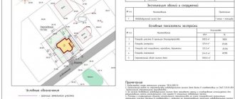
Consists of: Topographic survey on a scale of 1:500 or 1:2000 depending on the area and engineering structure; all underground and surface utilities located on the site with security zones, permanent structures, etc. should be displayed on the geobasis. This plan clearly confirms that the capital construction project (residential building or other building) does not violate security zones, is located in the zone of permissible placement of the building, and also complies with all the requirements of the urban planning plan and the Urban Planning Code of the Russian Federation.
- Topographic survey.
- Cadastral boundaries.
- Zones of permissible placement of buildings (Urban planning plan).
- Planned construction (House) with reference.
- The number of floors and materials of a residential building and its actual area and living area.
- Paths and entrances.
Where to order a territory planning project
You can order a land plot planning organization scheme (LPOSU) from us. The specialists of TopGeo LLC will prepare documents in accordance with all regulatory documents and will help in the delivery and solution of problems encountered in the development and delivery of the SPOZU.
List of required documents for SPRSU:
- Topographic survey on a scale of 1:500
- Certificate for land.
- Urban planning plan of the site.
- Extract from the Unified State Register of Real Estate.
- House project - if you have one!
The geodetic enterprise TopGeo will develop a plan for the planning organization of a land plot (SPOZU) in accordance with existing regulatory requirements and approve it in all interested control and supervisory authorities. We draw up SPOZU for individual housing construction and for legal entities that carry out large construction projects.
Form, structure and composition
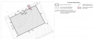
A ready-made diagram of the planning organization of a land plot for individual housing construction (a sample is available below) is represented by a schematic plan plotted on a topographic survey of the corresponding development zone . The standards and rules for its preparation regulate the use of symbols, in accordance with the Instructions adopted on the basis of the Federal Law on the Civil Code, No. 221-FZ, adopted on July 24, 2007, meaning:
- location of existing capital facilities;
- planned objects;
- established zoning regime for the territory.
These and other parameters of the land plot and information entered into the site planning organization scheme comply with the established requirements.
The form of the layout of the planning organization of a land plot with the designation of the object is as follows . On the right side, in a column at the top, the following data is entered:
- symbols;
- explication;
- building parameters;
- storage address.
In the center of the sheet is a diagram in the form of a drawing. Please enter information with notes below.
The structure is determined by the presence of sections that make up an example of an OPROM. These include :
- title page;
- schematic drawing of the memory;
- text explanations for the drawing;
- applications.
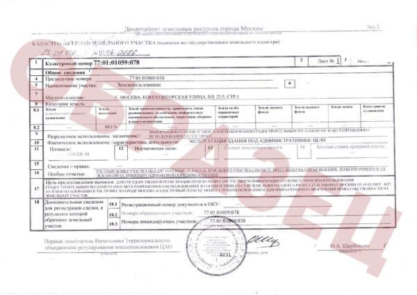
The composition of the OPROM is given in a list at the end of the document . Its elements are official information extracted from cadastral records or resulting from topographic calculations:
- Cadastral number of the land plot, number of the development plan - for erected buildings, structures or unfinished objects, in accordance with the information entered into Rosreestr.
- Coordinates of the boundaries of the turning points of the land plot and the boundaries of the site configuration.
- The total area of the allotment with the location of the actual capital buildings and the layout of the facilities that are planned for construction.
- Scheme of underground, above-ground and above-ground elements of engineering infrastructure.
- Adjacent roads and sidewalks.
- Other essential parameters and characteristics included in the development zone of the territory.
Regulatory regulations of legislation
In addition to the instructions based on the effect of document 221-FZ, the Town Planning Code of the Russian Federation plays a significant role in the regulatory procedure for drawing up a plan for the planning organization of a land plot for individual housing construction.
Resolution 87 dated February 16, 2008, which provides for the application and preparation of SPOZU for lands intended for individual housing construction, is of great importance for the scheme of planning organization of a land plot.
The sample SPOZU for individual housing construction provides for differences in the design of objects owned by legal entities and individuals on land of one category or another for the corresponding purpose.
The first part of the document contains a list of such objects and standards applied to each category of buildings.
The second part, in more detail, specifies the requirements for the lands of settlements intended for individual housing construction. Here are the rules for development and obtaining building permits for owners of residential buildings in the private sector.
According to PP No. 87, detailed information containing rules for the operation of individual and shared territory (sidewalks, roads, etc.) is required to be entered into the SPOZU for lands under individual housing construction.
Planning of an individual housing construction site: concept and legislation
The legislative conditions for the use of land plots for individual housing construction are contained in the Civil, Town Planning and Land Codes. In particular, the Civil Code grants land owners the right to freely use them, but on the condition that such exploitation does not harm the environment.
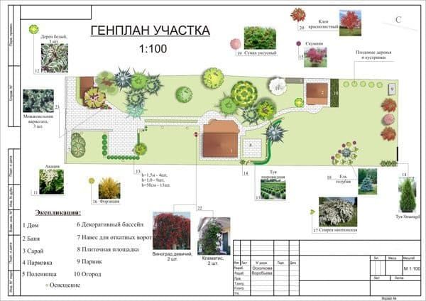
The layout of a land plot of individual housing construction is the proposed layout of residential and commercial buildings, recreational and planting areas, etc. This also includes the sequence of construction and landscaping work.
Planning of a land plot for individual housing construction must be carried out taking into account current building codes and regulations. The most important regulators of the construction of low-rise buildings are contained in the following regulations:
- SP 30-102-99 – planning and development of low-rise housing construction areas;
- SNiP 30-02-97 – planning and development of SNT and DNT territories, buildings and structures;
- SNiP 21-01-97 – fire safety of buildings and structures.
At the municipal level, individual rules and regulations may apply.
Typically, during the planning of a land plot, several zones are allocated: residential, utility (for a garage, shed, etc.), recreation area (for a gazebo, pond, etc.), an area for gardening and gardening, paths and passages.
Scheme of planning organization of a land plot for individual housing construction: features
According to the above standards, it is required to enter into the designated document not only information about the location of capital construction projects and others limited by the territory of the allotment. Since the plot is included in the development zone of the urban planning context, it can be succinctly included:
- to the historical zone of the settlement;
- to the environmental protection zone;
- into the sanitary zone, including by creating its gap;
- on the territory encumbered with a public easement.
These and similar nuances that make up the parameters of the memory, according to the requirements, must be included in the SRAM without fail..
Requirements for the preparation of the SOPSU
This document is subject to a number of requirements, without which it does not acquire legal capacity. These are divided into two categories:
- drafting requirements;
- certification requirements.
Requirements for certification are based on the place of preparation and certification of the document by the authorized administrative commission . They consist of the following:
- The interested person contacts the Committee or department for urban planning and architecture of the locality in which the site is located.
- Submits an application for the preparation of a document and receives a ready-made document certified by specialists.
- The executor certifies the SPOSU with the appropriate signatures and seal of the institution.
To acquire the legal capacity of the Scheme, it is required to include mandatory information and perform it in accordance with the Instructions:
- On an A4 sheet, large areas can be executed on an A3 sheet.
- It is made manually on paper, after which it is copied onto electronic media if necessary.
- Computer modeling with subsequent printing and identification is allowed.
- The drawing is executed in a single monolithic line without overlaps using a special drawing ink.
- Text material is presented legibly, without erasures or corrections in the text.
- Only printable characters of the letters and numbers used are used.
Where can I order?
The interested person contacts the local administration . If such services are not provided here, which is allowed by legal norms, you should order the SPOZU from a commercial company that prepares architectural projects and urban planning documentation.
If the planning object poses a danger to the life of individuals or citizens of a locality, the originator must have the appropriate license to authorize the execution of services (Article 48 of the Civil Code of the Russian Federation).
What do you need to provide?
After approval, the copyright holder of the land plot submits an application, to which is attached a package of documentation. It includes the following:
- applicant's passport;
- notarized power of attorney for representatives;
- certificate of ownership (other type of right);
- topographical survey of the memory;
- urban planning plan (extract).
Cost of services
Despite the varying prices for the indicated service, it is possible to identify the basic amounts presented for payment:
- Standard orders accepted in district, regional and regional centers are guided by 3,000-5,000 rubles.
- In St. Petersburg and the Leningrad region - from 5,000 rubles.
- In Moscow and the near Moscow region - from 5,000-6,000 rubles. In the far Moscow region, prices are equal to regional centers.
If the order is carried out by the administration of the locality, no payment is charged.
Deadlines
Depending on the presence or absence of a client queue, the SPOSU can be prepared from two weeks to one and a half months . It is customary to focus on one calendar month.
The terms must be established by agreement of the parties at the time of execution of the service agreement.
Decor
Before starting to develop a master plan for any land plot, you need to collect a set of documents:
- Cadastral plan showing actual boundaries and dimensions. The document provides a complete understanding of the actual picture of the territory being developed;
- A scheme for linking buildings to the system of general engineering networks and communications - water supply, sewerage, electrical networks, gas pipelines;
- A detailed map of the location of neighboring buildings, roadways and pedestrian sidewalks, and other objects located in the adjacent territory;
- A detailed description of the buildings planned for construction on the selected territory (house, agricultural buildings, etc.).
You might be interested in: What is a technical plan and why is it needed?
The general plan drawings are made to scale, indicating the prevailing wind rose in summer and winter and the location of the site relative to the cardinal points. The long side of the site boundary is located along the long side of the sheet. The axes of the construction coordinate grid are placed parallel to the worksheet frame lines. The upper part of the sheet corresponds to the northern side of the site (the orientation to the north can be changed within 90 degrees to the right or left).
The contours of the designed buildings are drawn according to the axial dimensions adopted in construction drawings, indicating doors and gates to scale. On the inside of the outline of the main housing construction indicate:
- house number according to the legend (in the lower left corner);
- a mark corresponding to the conventional zero mark of the horizontal location of the site.
Paving boundaries, entrance ramps, external steps and platforms adjacent to entrances and entrances are drawn around the contour. Coordination axes are tied to the boundaries of the site.
All symbols are drawn up in accordance with GOST 21.204-93.
The master plan is accompanied by:
- statements of houses and buildings for private and public purposes;
- a table with the technical and economic characteristics of the site - the building area; landscaping in square meters, the ratio of the area of construction projects to the total area of the site as a percentage;
- additional drawings of improvement objects.
Procedure
Designing a general plan begins with choosing a design organization. The first step is to contact the multifunctional center for the provision of state and municipal services (MFC) in the locality at the location of the land plot. From here, the documents are forwarded to local government bodies - the department of architecture and urban planning. The registration period according to the standard procedure is 30 days.
List of required documents
In addition to the above documents for drawing up a general plan for a summer cottage, clearly defined at the legislative level, there is no exhaustive list. This provision leaves territorial authorities the right to independently establish a list of mandatory documents.
Prepare:
- a written application for the issuance of a plan (a sample will be offered at the territorial MFC;
- a document confirming the identity of the applicant (power of attorney for a representative). For a representative of a legal entity, in the absence of a power of attorney, they will ask for an order to appoint a manager with the right of first signature;
- an extract from the state real estate cadastre - issued by the cadastral chamber of the territorial entity at the location of the property;
- technical passport of the capital construction project;
- topographic map of the plot of land of interest indicating above-ground, above-ground and underground communications.
You may be interested in: Everything about obtaining a town planning plan for a land plot
Structure (sample)
A sample master plan, including a drawing, is provided by the organization in which it is being developed. This allows you to avoid disputes when preparing the document locally.
Who to contact
In addition to the local department of architecture and urban planning, you can order a general plan from non-governmental commercial organizations and companies with a license for such activities. They are widely represented on the Internet. A list of companies involved in the development of master plans is available at local MFCs.
There are several options for applying for a master plan:
- personal appeal;
- through the transfer of documents by an official representative;
- by registered mail by Russian Post with notification of its delivery and a list of the contents);
- by email to the address of the official website of the city/district administration or territorial government agency);
- apply through the official portal of a government agency or a government services portal.
Approximate development cost
The approximate cost of services of companies in Russia is the same and ranges:
- for a plot of 500 sq. m – 1500 rub/sq. m;
- 1500 sq. m – 1000 rub/sq. m;
- 3000 sq. m – 700 rub/sq. m;
- 5000 sq. m – 400 rub/sq. m;
- 10000 sq. m – 300 rub/sq. m;
- 20,000 or more sq. m – 150 rub./sq. m.
The period for developing a GPZU (master plan for a land plot) is from 1 to 30 working days from the date of submission of documents.