All articles
12014
2020-03-13
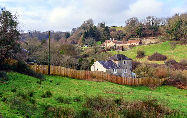
A specialist who has a license to carry out work knows what land surveying is. Land surveying is the establishment of land (plot) boundaries to determine the area and coordinates.
The concept appeared during the times of Kievan Rus, feudal lords established the boundaries of their possessions. The geodetic method of determining boundaries helped to mark the lands allocated for haymaking, forests, and arable land.
You will learn how to conduct land surveying, which is part of land cadastral relations, thanks to which you can rationally use land resources.
Definition of the concept
Land management takes place in accordance with land legislation; this document stores information on the use of land and the correctness of the land surveying process. Each site has its own characteristics and value. The position can only be determined by a surveyor based on the results of a thorough study of the proposed object.
Land legislation is being improved, new adjustments are being made, aspects that relate to the legal use of land. To become the full owner of your land, you need to carry out land surveying, but first you need to understand the very concept and purpose of this process.
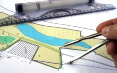
What is land surveying? The term means that this is a clarification, as well as a clear definition of the boundaries, the extreme points of the desired land plot. During the process, coordinates and the exact area are established, information is recorded in documents, a land certificate. The inspector carefully processes the information.
The concept of land surveying comes from the word “boundary”, which means the delimitation of territory. In legislation, division has a precise legal definition and a legal framework for carrying out the measurement process.
Every year, clarifications and changes are made to the Land Code; there are special organizations that deal with issues of dividing the territory, preparing documents, certificates and papers. All the nuances that relate to the correctness of the creation of the project and the regulations of the land plot are reflected in federal laws.
Before purchasing land or registering ownership of a house, you should contact such an office and verify the accuracy of the information in order to avoid unpleasant consequences. Inaccurate data may create difficulties during further re-registrations.
The process is carried out by a qualified surveyor, the preparation of documents takes time. It all depends on secondary factors, the location of the object, additional features. The specialist not only determines the clear boundaries of land ownership, but also conducts examinations and additional actions that determine the composition of the land, its quality, and location features.
An inspector is required to be involved when dividing the following territories:
- a protected area in which land for land surveying is located;
- the land for delimitation is located between the plots;
- the site is under court restrictions or prohibitions;
- rights to use land are disputed in court;
- unauthorized use of the land was carried out.
The work of the surveyor is paid by the applicant; a person can carry out land surveying on his own if his land plot does not fall within these areas.
It is worth considering that you need to contact a specialized office to obtain a certificate and legally certified papers. Payment is made in two stages, half of the amount is paid at the initial stage of work, after receiving the result, the owner pays the entire remaining amount. Receipts and other components of the transaction between the owner of the site and the cadastral organization must be preserved.
Where to go for help?
Land surveying is carried out by cadastral specialists, surveyors, and engineers. Their activity consists of geodetic work for land management. By contacting a specialist, you can get information and advice on how the procedure is carried out. Each case is considered on an individual basis.
The surveyor will tell you the intricacies of drawing up a plan for dividing the land, help you correctly draw up an application to the cadastral authorities, and help with registering property rights. The inspector will announce the entire list of documentation that needs to be collected to carry out the land surveying process.
The list consists of the following items:
- identity documents, copies and originals;
- a document that relates to the right to use land;
- extract, plan from cadastral registration;
- notification from the BTI, which confirms the absence of construction;
- cadastral document of the house, if there is one on the site;
- application to begin the land surveying process.
There are public and private surveying offices; the main indicator of quality is a certificate, a certificate of a qualified specialist.
The main thing is the reliability of the process of measuring all points; the engineer maintains high accuracy and reduces the error to a minimum. The Land Code provides a legal and regulatory framework for land surveying. There are public and private organizations that deal with the delimitation of land plots. You can contact any surveyor, the main thing is qualifications and work experience. The measurement process itself is labor-intensive and takes time.
The final result is influenced by the devices and their quality. The legislation specifies the permissible error that may be allowed during work. A good specialist will make all the calculations correctly if he has experience in such activities and accurate instruments.
In what cases is land surveying necessary?
Judging by recent changes in legislation, land surveying is a mandatory process of calculating the land that is owned. Rosreestr has the right to refuse the owner to register a land plot if its boundaries are not clearly marked or extend into another territory. Registration in the cadastre will be refused if there is no information about the extreme points of the borders.
Land legislation specifies that no manipulations with the site are possible if land surveying has not been carried out. Legally significant processes are impossible without a boundary plan, which is drawn up only after an application from the user.
After completing this document, the owner receives a cadastral document, on the basis of which he has every right to carry out the following processes:
We recommend that you read:
How long does it take to survey a plot of land?
- carry out the sale of land;
- exchange land for other property;
- draw up a deed of gift;
- privatize a plot of land, become its full owner;
- divide the site or combine several objects;
- legal proceedings regarding land can only be based on cadastral documentation, which is drawn up on the land survey plan;
- transfer of land to inheritance.
Only land that has a special meaning and is called undivided is not subject to division.
In the event of the sale of a plot from a given territory, the land must be divided into borders and boundary points. Defining boundaries is based on two main tasks:
- Dividing the total land territory into plots, fixing the extreme points of each plot.
- Assigning the boundaries of the site to the subject, determining the exact coordinates and extreme points of the site.
Many individuals who are faced with this procedure for the first time refuse such services, thereby driving themselves into a dead end. The whole process takes time, but it is necessary to carry out legal actions with your land. If a citizen has issued a written refusal to survey, then disagreements may arise with neighbors regarding the boundaries of each division.
Preparation
Preparation of the land surveying project is carried out in accordance with the requirements for the land surveying project. It contains a list of all criteria for compliance of documentation with standards regulated by federal law, which are contained in Order of the Ministry of Economic Development of Russia dated August 3, 2011 N388.
Preparation items include:
- On the rules for drawing up a map of a land surveying project;
- About the sheet format (A-4);
- On the use of stationery for writing (pencil is not allowed);
- On the use of exclusively Russian language;
- On the rules for numbering sheets and using exclusively Arabic numerals;
- Rules for transferring data to the next sheet;
- About the project points;
- About the total volume of the project text;
- About the rules for its compilation, in general.
The corresponding preparation requirements indicate the standards of the survey project according to the following parameters:
- Information about the customer;
- Information about the performer;
- Explanatory note;
- Initial land cadastral data;
- Cadastral data on the parts of the site created in planning;
- Information about access to the sites for relevant persons;
- Graphic plan;
- Availability of relevant applications.
Sequencing
The real estate object, which is the land plot, is registered, all boundaries have exact coordinates. This is possible only after a complete description of the object. The sequence of actions is coordinated by land legislation; the cadastral engineer has the right to work based on articles of federal legislation.
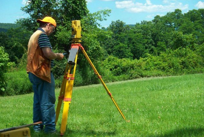
The work of an inspector is labor-intensive; it is necessary to measure a site of any given area, then analyze the work and create a documentation base. In his work, a technician uses boundary signs, tools with which he establishes boundaries and fixes them. Boundary marks are used both on paper and on a plan, which serves as a cadastral document for the owner. The engineer prepares not only a plan for one plot of land, but also creates topographic maps and plans. The end result should fully reflect the appearance of the territory.
Determining boundaries takes place in several stages:
- The engineer analyzes information, information about the facility, and conducts an analysis of neighboring areas. If the territory is located between several objects, then the specialist notifies all interested parties. If boundaries are violated, it is necessary to solve the problem together. The order of the process may be changed if the neighboring area is subject to land surveying.
- The process of geodetic surveying, during which the engineer determines the coordinates and exact location of the object.
- At the end of the measurement process, the technician submits the prepared documents to the cadastral institution; after the expiration of the period, the owner will receive a ready-made cadastral passport, which confirms the right to dispose of the land.
The stages are interconnected, only after a full analysis and inspection of the territory will the engineer be able to make a conclusion and prepare truthful documents for submission to the cadastre.
Preparation of the project itself is a key point in the entire land surveying process. The end of the cadastral engineer’s work is the submission of documents to Rosreestr to secure the boundaries. This moment is considered final; it gives the boundary plan legal force; without it, the procedure is not considered valid.
Documentation
The inspector’s activities should take about 14 days; during this period he undertakes to carry out measurement work and analyze all the information. To notify neighbors and receive a response from them, 30 days are allocated from the date of receipt of the application by the cadastral engineer. The final document is the user's territory passport, which bears the signature of the engineer and the seal of the cadastral organization.
The document can be in electronic format or on paper; it contains all survey points.
Paper is needed in the following cases:
- the document is the main reason for registration in Rosreestr;
- the main document in legal proceedings concerning land.
The listed cases are not the only ones when the obtained certificate can be used.
A land survey plan is an important document that consists of the following information and information:
- Analysis of cadastral works.
- Information that relates only to the site.
- Additional materials on the specified territory.
- Records of measurements, exact coordinates.
- General conclusions of the inspector that he was involved in a specific case.
- A document where the owners certified the land survey boundaries.
Having completed the process, the owner has the right to independently dispose of the final document, namely, take it to court to clarify the circumstances, sell the plot and many others.
Having completed the land surveying process, the owner can be considered the full owner of his land, perform any lawful legal procedures with it, and dispose of his property.
What is land surveying?
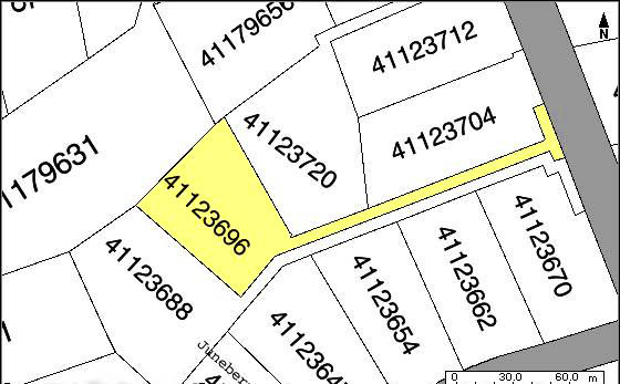
Land surveying is carried out by placing boundary signs , which are special signs and designate control points on the ground. Special signs can be both natural objects created by nature itself (river, lake) and artificial objects.
Most often, the boundary is a pillar with a sign on which a certain mark is made. The distance between them should not exceed 200 m. When installing special signs, the owners of the plots must be present.
Why is it needed on the ground?
There are a number of situations in which land surveying should be carried out:

redistribution of land plots. If you need to combine several different plots into a single one or, conversely, separate one plot into several.- Clarification of the boundaries and sizes of land plots.
- Before registering land ownership.
- To allocate partial shares during inheritance.
- Resolution of controversial issues when applying to judicial authorities.
After completing boundary work, the owner becomes more protected from the encroachments of neighbors on the location of his territory. He can also dispose of the land at his own discretion and make transactions with it.
From January 1, 2020, without the registration of the boundaries of the land plot, none of the transactions is possible according to Federal Law No. 447.
More information about why land surveying is needed can be found here.
Who delineates the boundaries of the land?
Land management work related to the establishment of land boundaries can be carried out by organizations that have received permission for this type of work, as well as government agencies related to design and survey work.
When choosing an organization, you should pay attention to the presence of such specialists as the cadastre on staff. engineer, surveyor, topographer, lawyer. In this case, it is possible to receive high-quality work and legally correctly executed documents. If the boundary is drawn up inaccurately and is of poor quality, Rosreestr will not accept such a boundary plan. We will have to look again for another organization and spend new funds.
You can find out who does the land surveying here, and in this article we talked about the rules for carrying out geodetic work when surveying land plots.
Turnaround time

Work on establishing boundaries directly on the site takes from 1 to 3 days. Everything is determined by the area and location of the site. Drawing up the boundary plan itself will take several days.
The most time-consuming will be the coordination of boundaries with the owners of adjacent plots. Each owner of adjacent plots must be agreed upon individually. If it is impossible to find all neighbors, then an announcement is published in the media about a meeting to agree on the boundaries of the plots. This notice must be filed 30 days before the meeting. With this procedure, the period for creating a boundary plan can take up to 3 months.
Documents for land surveying
To submit an application for land surveying, you must provide a package of documents. In order to avoid red tape, you should seek help from a cadastral engineer, who will provide a list of certificates and documents for the process. Private entrepreneurs and legal entities must prepare additional papers that regulate their activities.
An individual provides the following documents to the cadastral service authorities:
- cadastral planning;
- inventory plan;
- documents that relate to a specific land plot;
- document confirming the right of use;
- personal documents, additional benefits, nuances.
The cadastral engineer accepts the papers and issues a list to the applicant.
Upon completion of the work, the surveyor gives the applicant the final result, which contains information about the site with exact coordinates and boundaries. Neighbors in the area were notified about the land survey and gave written consent to the deal; this approach is convenient and allows you to avoid troubles. A cadastral plan is drawn up that complies with all legal regulations. The document is registered with Rosreestr and assigned a cadastral number.
The results may be disputed if a conflict arises due to disagreement over the boundaries of a certain area and disputes arise with the owners of neighboring territories. SNT involves maintaining a personal garden on your own plot of land; such a moment requires a clear delineation of the object.
The latest change in legislation has led to an increase in demand for land surveying. Applicants contact a public or private service for services to avoid queues. The main indicator is surveyors with experience who have a seal and the right to carry out land surveying.
We recommend that you read:
If there is a cadastral number of the land plot, is land surveying necessary?
Conditions and special requirements for carrying out a land surveying project
Coordination and implementation of a land surveying project is required for planning built-up structures or infrastructure or capital construction to be built. A mandatory requirement of the PMT is a clear image on the graph with appropriate marks, as well as text support for the document.
A land survey plan is created as part of a single land plan or as independent documentation. Based on this, the drawing should reflect the information:
- Red lines separate the territory from general purpose lands.
- Lines with a permissible indentation in the form of drawing from red marks indicate areas where structures and utility networks are located.
- The boundaries of built-up land plots are a mark about a previously constructed linear object.
- The boundaries of new land plots - when planning the issuance of physical properties for development. or legal persons.
- The boundaries of the separation of cultural objects with indentation from the bordering land.
- The boundaries of the location of future capital buildings indicate local, regional or federal facilities.
- Territories with specific rules of use.
- Boundaries of public lands with limited use rights based on legislative regulations.
- At the design stage, the specific location of a specific land plot, including adjacent land plots, is taken into account.
Composition of the survey project
PMT includes both an analytical component and a graphical one.
The first contains:
- characteristics of the boundaries of the land plot;
- terrain properties;
- calculations;
- justification for the need for land surveying.
The latter includes a drawing of the land plot indicating red lines and the location of structures, if any. Additionally, the technical documentation contains information about the numbering and name of adjacent memory units.
The customer pays the cost of the activities carried out, enters into a contractual relationship with the geodetic company and pays for the work of the engineer.
Land surveying of a site owned by several owners
When surveying, various nuances may arise that relate to a specific site and adjacent properties. Situations are possible when the land was without an owner, and neighbors occupied its borders. To prevent this from happening, land surveying should be carried out; documents at the end of the process will help restore rights if necessary.
The financial factor should be taken into account: all work costs money. In addition to the monetary side, you need documents that can be difficult to collect. If at least one certificate or document is not available, then the survey cannot be completed. Only if all the required documents are available, the surveyor can begin the land surveying process.
A plot of land may have several owners, the reasons for this are different, depending on the situation:
- If several people receive an inheritance at the same time, they claim to equally divide and receive their share.
- When combining several plots into one object, after this process it is necessary to carry out land surveying and create new documentation for the territory.
- Shared ownership of land, as well as real estate objects located on the specified site.
- Division of an object to another individual, according to the presented document.
Any of the above situations may arise, but it can only be resolved by correctly registering land ownership.
With the help of current legislation, it is necessary to delimit the territory; this is the only way to solve the problem that has arisen. In order to agree on the boundaries of the combined plots, their owners must receive official notification two days before the start of land surveying and study of the property. Owners receive notifications according to the state standard. The agreement to this transaction or refusal must be included in a regulatory act.
You can use the land only based on current legislation. Each request for land surveying has its own characteristics and nuances, all cases are considered carefully, the package of documents and information on a specific object is checked. If there are several owners, then both parties provide documents.
Coordination of land boundaries during land surveying
Coordination of land boundaries during land surveying
Yulia Morozova
02.04.2018
cadastral engineer, boundary plan, owners, clarification
Land plots, Cadastral engineers, Boundary plan, Cadastral registration procedure, Land owners
No Comments
Let us consider in this article what constitutes coordination of the boundaries of a land plot, and in what cases it should be carried out.
Let's say you ordered a survey of a land plot in order to enter information about its boundaries into the Unified State Register of Real Estate ( USRN ). The initial stage is a geodetic survey of the land plot, after which the cadastral engineer calculates the area of the plot and the lengths of its sides.
Afterwards, an Act of Coordination of the Location of the Boundaries of the Land Plot is drawn up, indicating the names of the neighbors with whom the coordination needs to be carried out (take signatures).
!!! Putting your personal signature on the boundary approval act means that you agree with the position of the fence that is installed on the ground (with the actual boundaries of the land plot).
Owners of adjacent plots have the right to approve only the adjacent part of the border of the land plot being specified, that is, that part of it that is also part of their plot.
Owners of adjacent plots do not have the right to submit objections to parts of the boundaries that are not adjacent to their plots, as well as to sign the Act for a fee.
Coordination of the location of boundaries is carried out with persons who own adjacent land plots by right :
1) property;
2) lifelong inheritable ownership;
3) permanent (unlimited) use;
4) lease (if such adjacent land plots are in state or municipal ownership and the corresponding lease agreement is concluded for a period of more than five years).
Persons who are not provided with adjacent plots with the rights specified above do not have the right to coordinate adjacent boundaries.
Information about the owners is collected by the cadastral engineer, ordering extracts for adjacent plots from Rosreestr.
There are two ways to coordinate the boundaries of land plots. The cadastral engineer independently chooses the approval method. Let's look at each of them.
1 way. Coordination of boundaries on an individual basis.
This method is the most convenient and fastest, and assumes that the signature of each interested party is collected separately. That is, there is no need to gather all neighbors in one place and notify them in advance.
Method 2. Conducting a meeting of stakeholders.
This method is less popular, but in some cases it cannot be avoided (for example, if one of the neighbors is in another city or his location is unknown).
In this case, the cadastral engineer looks at extracts from the Unified State Register for each adjacent land plot and checks for information about the email address or postal address of all neighbors.
If there is such information for all adjacent areas, then the cadastral engineer delivers Notices to interested parties about holding a meeting to agree on the location of boundaries against receipt, or sends Notices to the email address or postal address indicated in the extracts from the Unified State Register of Real Estate, with acknowledgment of delivery .
Publication of a notice of a meeting to agree on the location of boundaries is permitted if:
1) the Unified State Register does not contain information about the email address or postal address of any of the interested parties, or a notice of a meeting to agree on the location of borders has been received, sent to the interested person by mail, with a note indicating the impossibility of its delivery ;
2) the adjacent land plot is located within the territory of a horticultural, gardening or dacha non-profit association and belongs to common property , or is part of agricultural land and is owned by more than five persons , or is part of the common property of the owners of premises in an apartment building ;
3) land plots in respect of which cadastral work is carried out are forest plots .
Here it can be noted that if Rosreestr does not have information about his contacts (email and postal address) for at least one neighbor, then you can safely submit an advertisement in the newspaper.
However, there are two nuances here. The first is a paid ad (about 2000 rubles). Second, you need to wait exactly one month after posting the ad. If within a month the cadastral engineer has not received any objections regarding the boundaries of the land plot being specified, the boundary is considered agreed upon.
1) information about the customer of the relevant cadastral work, including postal address and contact telephone number;
2) information about the cadastral engineer performing the relevant cadastral work, including his postal address, email address and contact telephone number;
3) cadastral number and address of the land plot in respect of which the corresponding cadastral work is being carried out, cadastral numbers and addresses of land plots adjacent to it (in the absence of addresses, information about the location of the land plots is indicated) or the cadastral number of the cadastral quarter within the boundaries of which the specified land plots are located ;
4) the procedure for familiarizing yourself with the draft boundary plan , the place or address where this project can be familiarized with from the day of delivery, sending or publication of the notice;
5) place, date and time of the meeting to agree on the location of the boundaries;
6) deadlines and postal address for the delivery or sending by interested parties of requests for coordination of the location of boundaries with the establishment of such boundaries on the ground and (or) in writing justified objections to the location of the boundaries of land plots after familiarization with the draft boundary plan.
Notice of a meeting to agree on the location of boundaries must be served, sent or published at least thirty days before the date of this meeting .
!!! An interested person who refuses to accept notice of a meeting to agree on the location of boundaries is considered to have been duly notified of the meeting.
1) check the powers of interested persons or their representatives;
2) provide the opportunity for interested parties or their representatives to familiarize themselves with the relevant draft boundary plan and provide the necessary explanations regarding its content;
When coordinating the location of boundaries, interested parties present to the cadastral engineer identification documents , documents confirming the powers of representatives of interested parties, as well as documents confirming the rights of interested parties to the relevant land plots (if information about the owner is not in the Unified State Register of Real Estate).
The act of agreeing on the location of the boundaries is drawn up on the back of the Drawing of the land plot.
The location of the boundaries of the land plot is considered agreed if the act of agreeing on the location of the boundaries contains personal signatures of all interested persons or their representatives. Details of documents proving the identity of such interested persons or their representatives, indicating the details of documents confirming the powers of representatives of interested parties, are indicated in the approval act.
If a duly notified interested person or his representative within the prescribed period has not expressed his consent by certifying with a personal signature the act of approving the location of the boundaries or has not submitted his objections to the location of the boundaries in writing with their justification, the location of the corresponding boundaries of the land plots is considered agreed upon by such person . than the corresponding entry is made in the act of agreeing on the location of the borders. The cadastral engineer attaches to the boundary plan documents confirming compliance with the procedure for notifying the specified person.
If the location of the relevant boundaries of the land plots is not agreed upon by the interested party, and such person has submitted in writing objections to this approval with justification for the refusal, entries about the content of these objections are made in the act of agreeing on the location of the boundaries . Objections submitted in writing are attached by the cadastral engineer to the boundary plan.
All disputes regarding the boundaries of land plots are resolved in court!
Tweet
Read other interesting articles:
Preparation of technical plans based on technical requirements. passports issued after January 1, 2013
In this article we will find out whether it is possible to prepare technical plans on the basis of technical passports produced by technical inventory authorities after January 1, 2013.
How to register a zone with special conditions for the use of territories for cadastral registration in 2020?
In this article we will look at how to currently register zones with special territorial conditions for cadastral registration.
How to check a property when purchasing?
There are a huge number of ways scammers deceive customers. Therefore, in order not to be left with nothing when buying an apartment or land, it is worth checking everything yourself.
Features of the land surveying procedure
It is worth considering that the procedure for establishing boundaries itself is not forced, but surveyors recommend complying with all the rules of land legislation and using the land after delimitation. It is important to know that it is possible to register ownership of a land plot without clearly established boundaries.
The main indicator for this is authentic documents that can confirm the right to use the land. Such a document may be a will or a deed of purchase of ownership of an object.
An ordinary citizen cannot carry out all the necessary measuring work himself. With clear angles, there is still a possibility of making mistakes; without knowledge and special equipment, this procedure is impossible.
Each piece of land is special, it may border on a field or a nature reserve, in which case the surveyor will make all the necessary calculations and set the correct boundaries. To confirm your ownership, you need a document that will be certified by the cadastral organization. Surveyors have a license to carry out work, as well as a seal, which is a guarantee of the legality of the actions.
The presence of such a document allows its owner to conclude a deed of sale without any problems, and there is no need to pay additional amounts for measuring and establishing boundaries. The object already has clear boundaries, which are documented. The buyer can order a surveyor himself and pay for his services.
If the real area does not correspond, then the following solution to the situation is possible:
- The indicated territory is smaller than the one presented, in this case the seller is obliged to make a refund. The buyer has every right to terminate such a transaction due to an unscrupulous seller.
- The actual area is larger than that indicated in the document, the owner is losing his finances, and a land surveying process will be necessary.
Land marking has another advantage: when taking measurements, there is a legal way to make the area of your object larger. Such a clause is acceptable only if the land does not have an owner, the surveyor conducts a thorough analysis and can carry out the annexation of additional area. Land surveying and division of land allows land use to be guided only by legal and regulatory aspects.
How is land surveying carried out?
The basis for initiating the land surveying procedure is a written statement from the customer of the work. In this case, the customer must either be the legal owner or use the land under various conditions. It can be:
- unlimited use;
- lifelong inheritance;
- property transaction.
The filing party may be a legal entity or an individual and may also have an interest. In the latter case, each owner of his share must submit an application. As an option, the application is submitted by a representative of all parties. And one more thing: when contacting the relevant services, the applicant must be ready to document his rights.
You need to start the process by contacting the geodetic company closest to the location of the land, which must have a license to carry out this type of activity. The customer can be either the landowner himself or his representative. The submitted application must be accompanied by a package of documents (for this you need originals and copies of documents):
- applicant's passport;
- notarized power of attorney (for representatives);
- title document (this could be, for example, a purchase and sale agreement or an act of allotment);
- Rosreestr certificate on the form of title to the plot;
- cadastral number - if available.
Why are apartments in Moscow and the Moscow region more expensive than houses?
Investing in real estate. What do the professionals advise?
Lands of settlements (LNP): types of permitted use
Combined stone and wood houses. What's the trick?
Houses and cottages with Moscow registration. What villages are represented in the capital's private sector?
August in the garden. What to do on your site?
Do-it-yourself water-heated floors: installation diagram, installation technology
How to properly register land rights? The procedure for registering ownership of a land plot
Cottage sewage systems. Septic tanks and other methods of drainage in private homes
Which kitchen countertop should you choose for your home?
Main stages of the procedure
Current legislation very clearly outlines the order in which the described procedure is carried out. Land surveying takes place in several stages:
- the applicant collects all the necessary documents - clearly establishing ownership and others, as well as additional information and reference materials relating to this plot;
- clarification of boundaries and coordination with adjacent land users - a geodetic survey is carried out to determine the area and lengths of all sides;
- drawing up a boundary plan based on the information received, which is necessarily included in the plan in the appendices;
- transfer of the drawn up boundary plan to Rosreestr;
- registration of a cadastral passport.

Features of land surveying of your own land plot
Usually a citizen has in his hands a document certifying his ownership of the land. In addition to this, the owner of the plot has a paper that became the basis for issuing a certificate of ownership:
- donation and sale agreements;
- inheritance paper;
- administration resolution on the allocation of land, and so on.
Make good, legible copies of all these papers. Their notarization is not required by law. But officials in regions and cities (except Moscow) may require this to confirm authenticity. Additionally, it makes sense to order an information sheet from the local architecture office that contains a variety of important information, including location (diagram), zoning features, and other data.
Who to contact?
Find a land surveying company in your city. Keep in mind that only a cadastral engineer with the appropriate qualifications and a special certificate, who can either work for such a company or be an individual entrepreneur, has the right to make a boundary plan correctly.
Study current prices, find and read customer reviews. Now, after you are convinced of the affordability of the services and the high qualifications of the contractor, proceed to the process of concluding a contract.
Divide the payment for the work into two parts - prepayment and final payment after completion of all work. Agree with the engineer about the time at which he will arrive at the site to carry out all the necessary measurements and studies.
It is especially important to pay attention to the correctness and accuracy of the contract. This document will help you defend your rights if land surveying work is completed behind schedule or with insufficient quality.
Now comes the most difficult stage. On it, the boundaries determined by measurements are agreed upon with adjacent land users. The agreement is carried out by a specialist, talking with each of the neighbors. As an option, a meeting of interested parties is convened, and approval is carried out based on its results by a list. If disagreements arise, special acts are drawn up as appendices to the boundary plan. An act of agreement is drawn up, and disagreements, if any, are settled in court.
Finally, the finished paper is handed to you. Immediately, without delay, submit it to the Rosreestr authorities. There they will check it and register your land. In the age of information technology, it is most convenient to issue a boundary plan to the customer in electronic form. In the same way, on electronic media, the paper is submitted to government authorities. However, you will need to attach a paper version printed on a printer to the electronic version.
Soon after submission to Rosreestr (if there are no errors or inaccuracies in the boundary plan), you will be given a cadastral plan of the site. This paper indicates, in particular, that all available information about this land ownership, its owner and boundaries is entered into the State Real Estate Cadastre.
The land surveying process cannot be called particularly difficult. But it requires unconditional compliance with all rules, the most current requirements of current legislation and accurate execution of all work. Therefore, it is recommended to carry it out only with certified specialists of the highest qualifications.